Matrice 400 in High-Altitude Forest Recon
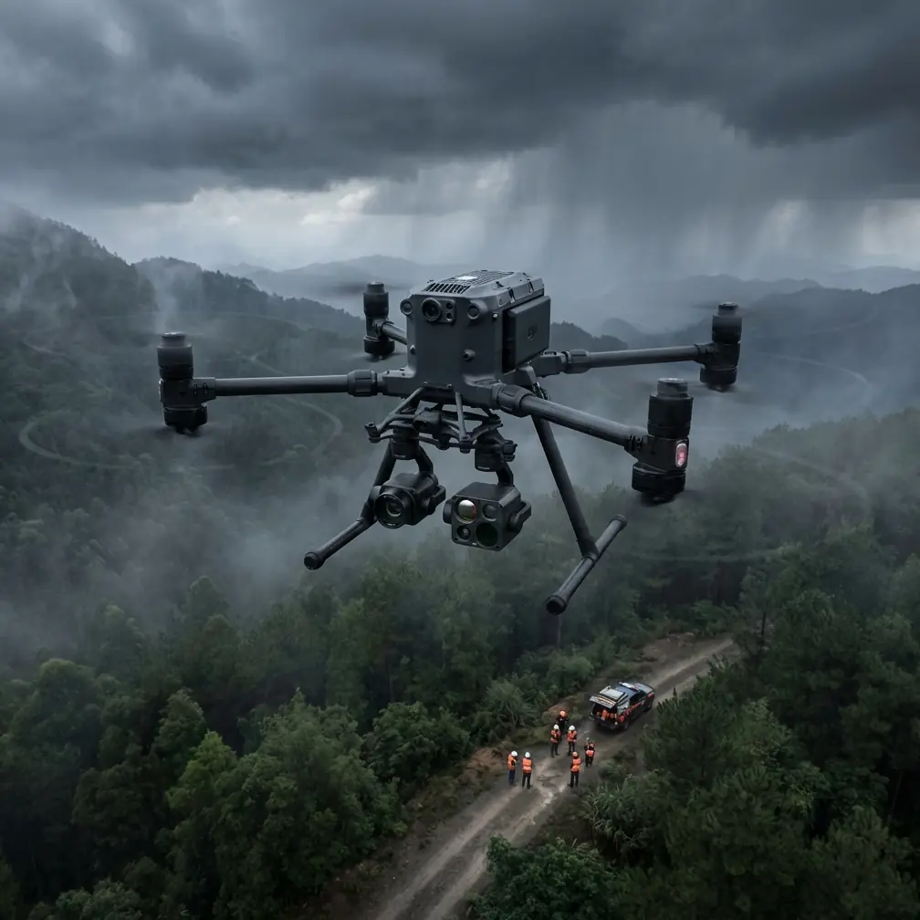
Matrice 400 in High-Altitude Forest Recon: A Field Report on What Actually Matters
META: Expert field report on using the Matrice 400 for high-altitude forest scouting, with practical insight on thermal signature work, photogrammetry, O3 transmission, AES-256 security, hot-swap battery workflow, and BVLOS planning.
High-altitude forest work exposes weak aircraft fast. Thin air cuts lift. Valleys interfere with links. Temperature swings punish batteries. Tree canopy hides what the naked eye should be able to see but often cannot. If you are scouting timber stands, checking post-storm damage, assessing wildfire recovery, or planning access routes in steep terrain, you do not need a pretty spec sheet. You need a platform that keeps its composure when the mountain stops being cooperative.
That is the lens I’m using here.
This field report is built around the Matrice 400 as a serious commercial tool for forest scouting at elevation. Not as a generic enterprise drone. Not as a checklist of features. The real question is simpler: how does it behave when the mission involves cold mornings, long transects, obstructed sightlines, and data that has to hold up later in GIS, planning, or environmental review?
Why high-altitude forest scouting is a different kind of job
A lot of drone advice is written from the perspective of open fields or lowland inspection sites. Forest reconnaissance in mountain terrain is another category entirely.
At elevation, the aircraft works harder to hold position and maintain consistent flight performance. Wind is often layered rather than uniform. You can lift off in calm air and meet lateral gusts just above the canopy. Add conifers, ravines, and uneven solar heating on slopes, and flight planning becomes less about clean geometry and more about preserving margins.
Then there is the sensor problem. Standard visual imagery still matters for stand density, route tracing, slope hazard review, and photogrammetry. But in forest work, thermal signature analysis can reveal what visible imaging misses: stressed vegetation pockets, retained moisture zones, animal-related disturbance patterns relevant to ecological surveys, and residual heat anomalies after a fire event. That makes payload strategy central, not secondary.
This is where the Matrice 400 starts to make sense as more than a lift platform.
Transmission reliability is not just convenience
One of the most practical advantages in mountain forest operations is stable long-range command and video performance. O3 transmission is often discussed as a marketing bullet, but in steep woodland terrain it has operational weight.
When you are flying across ridgelines or along a drainage corridor, signal continuity determines whether you can maintain an orderly mission profile or end up breaking runs into overly conservative fragments. In forest scouting, that means the difference between one complete data collection window and multiple partial attempts with inconsistent light conditions.
For teams working under formal operating procedures, especially where BVLOS frameworks are part of the planning discussion, robust transmission is tied directly to risk management. Even if every mission is not conducted beyond visual line of sight, the planning discipline behind BVLOS-ready operations improves the whole workflow: route segmentation, communication checks, lost-link actions, alternate landing zones, and battery reserve triggers. A drone that supports dependable link performance gives crews more room to operate methodically rather than reactively.
O3 matters here because forests and mountains are harsh on radio behavior. Reliable transmission preserves continuity in live framing, terrain awareness, and sensor tasking. It also reduces the temptation to reposition field teams unnecessarily, which can be a major issue in remote stands where access by vehicle is limited.
AES-256 is not an abstract IT feature in forestry
Most flight crews do not think about encryption until they have to. They should think about it earlier.
AES-256 security is especially relevant when the mission data includes infrastructure adjacency, protected habitat mapping, land boundary context, or pre-development environmental records. High-altitude forest scouting often overlaps with sensitive datasets, even in entirely civilian projects. Utility corridor planning through woodland, watershed monitoring, conservation inventories, and replanting assessments all produce imagery and map layers that need controlled handling.
If your operation includes contractors, consultants, landowners, environmental specialists, and GIS teams, secure transmission and data governance become part of professionalism, not bureaucracy. AES-256 is significant because it supports a cleaner chain of custody for the information collected in the field. That matters when the output is used for planning decisions, permit support, or technical reporting.
In other words, this is not just a drone feature. It is a project integrity feature.
Hot-swap batteries change how mountain crews work
In forest terrain, launching is usually easy. Staying efficient all day is the challenge.
Hot-swap batteries are one of those capabilities that sound minor until you are rotating sorties from a cold, uneven staging area with a limited weather window. In high-altitude scouting, battery management is one of the first places experienced crews separate themselves from casual operators.
The value of hot-swapping is not simply speed. It is continuity. You preserve mission rhythm, keep payload setup intact, reduce repeated system restarts, and maintain more consistent sortie turnover between mapping legs and targeted inspection passes. If you are trying to capture matching photogrammetry blocks before cloud cover shifts, shaving downtime between flights can preserve dataset quality.
In practical terms, hot-swap workflow also helps when you are combining broad-area visual mapping with follow-up thermal work. Thermal results are highly sensitive to timing. A slope face that reads clearly early in the day may flatten thermally once solar loading changes. Faster turnaround keeps the aircraft in the useful thermal window.
For mountain teams, I would go further: battery handling procedures should be treated as a formal part of mission design. Keep packs warm before launch in cold conditions, log voltage trends carefully, and plan each sortie with descent margins that respect terrain rather than simple percentage rules. Hot-swap capability supports that discipline because it removes some of the friction from doing things properly.
Photogrammetry in forests: what the Matrice 400 helps with, and what it does not solve
There is a common mistake in forest mapping: assuming the aircraft alone determines model quality. It does not. Dense canopy, elevation change, shadows, and repetitive texture can still degrade outputs no matter how capable the platform is.
That said, the Matrice 400 is well suited to photogrammetry workflows in mountain forestry because it supports the kind of stable, repeatable acquisition pattern these jobs require. Repeatability matters more than many teams realize. If your overlap is inconsistent, your speed fluctuates in wind, or your line spacing drifts with terrain, the resulting orthomosaic and surface model become less trustworthy for operational decisions.
For scouting purposes, photogrammetry is most useful when the goal is route planning, terrain interpretation, canopy boundary review, erosion tracking, or documenting change over time. It is less effective for seeing through canopy than some clients initially assume. That expectation needs to be managed early.
This is where GCPs come in. Ground control points are still one of the cleanest ways to improve spatial confidence, especially in complex relief. In steep forest environments, relying solely on onboard positioning can leave you with enough drift to complicate alignment with existing GIS layers, trail plans, culvert records, or historical survey data. Even a limited GCP network, placed in accessible openings or along approach corridors, can materially improve the usefulness of the final map.
The operational significance is simple: better geospatial alignment means fewer downstream arguments. If a forest manager, ecologist, or civil contractor is going to use the data for real decisions, GCP-backed products reduce uncertainty where it counts.
Thermal signature work above the tree line and below it
Thermal imaging in forest scouting is often misunderstood as a search-only tool. That is too narrow.
In high-altitude operations, thermal signature analysis can support vegetation stress review, drainage interpretation, post-disturbance assessment, and infrastructure interaction studies where the forest overlaps with assets such as access roads or utility spans. The reason it matters in mountain terrain is contrast. Cold air pools, exposed ridges, wet pockets, and solar asymmetry between slope aspects all create conditions where thermal differences can tell a richer story than RGB imagery alone.
The Matrice 400 becomes especially useful when carrying a thermal-capable payload alongside a visual sensor strategy that is planned around the same objective, not tacked on afterward. Thermal data without contextual visual reference often leads to overconfident interpretation. Combined datasets are far stronger.
One pattern I have seen work well is this: begin with a visual reconnaissance run to establish terrain logic, identify canopy openings, and verify route safety; follow with thermal passes targeted to drainage lines, stress zones, or post-event anomalies; then, if mapping is required, fly a structured photogrammetry block while light remains consistent. The aircraft’s ability to support demanding field tempo is what makes that sequencing practical.
A third-party accessory that genuinely improved the mission
Most accessories are optional. One category is not: landing support.
In alpine or near-alpine forest staging areas, I’ve seen a heavy-duty third-party foldable landing pad make a real difference. Not because it looks professional, but because it cuts down rotor wash contamination during takeoff and landing on dusty clearings, pine needle beds, and loose gravel pull-offs. With enterprise aircraft and expensive sensors, that matters.
The accessory sounds mundane, yet its impact is measurable in daily operations. Cleaner launches mean less debris around gimbals and connectors, fewer interruptions for lens checks, and less time spent trying to improvise a flat surface on rough ground. In a high-altitude forest workflow where crews may relocate several times in a day, that kind of friction reduction adds up. It is one of the rare add-ons I would recommend without hesitation.
If your team is refining a mountain scouting kit and wants a practical setup discussion rather than theory, this is a good place to message a field specialist directly.
What operators should pay attention to before deployment
The Matrice 400 is capable, but mountain forestry still punishes loose planning. A few points deserve emphasis.
First, define the mission by decision outcome, not by sensor novelty. Are you scouting access routes, quantifying storm damage, checking replanting progress, or producing terrain context for a consultant? The answer determines whether your priority is thermal contrast, map consistency, close visual inspection, or repeat surveys.
Second, build terrain into the flight plan from the beginning. Relative altitude choices, return routes, and battery reserves must account for relief. A route that looks conservative on a flat map can become inefficient or risky once slope and canopy are considered.
Third, use GCPs where the output needs to fit other data layers cleanly. The extra field time is often minor compared with the time lost later explaining mismatches.
Fourth, treat transmission and encryption as operational systems, not passive features. O3 and AES-256 only deliver value when your team has disciplined procedures for mission setup, device handling, and file management.
Finally, respect the environment. Cold-soaked batteries, narrow weather windows, and shifting visibility are ordinary in high-altitude forests. The best aircraft in the class still depends on good judgement.
The larger takeaway
What stands out about the Matrice 400 in this kind of work is not one headline feature. It is the way several practical capabilities combine under pressure.
O3 transmission supports more stable mission execution in obstructed terrain. AES-256 helps protect sensitive project data as it moves through field workflows. Hot-swap batteries preserve momentum when weather and thermal windows are tight. And when paired with disciplined use of photogrammetry, GCPs, and thermal interpretation, the platform becomes useful in the way professionals actually need useful tools to be: consistent, predictable, and adaptable.
For high-altitude forest scouting, that is the standard. Not novelty. Not raw power alone. Dependable output from difficult ground.
Ready for your own Matrice 400? Contact our team for expert consultation.