Matrice 400 in Mountain Forest Recon: A Field Report
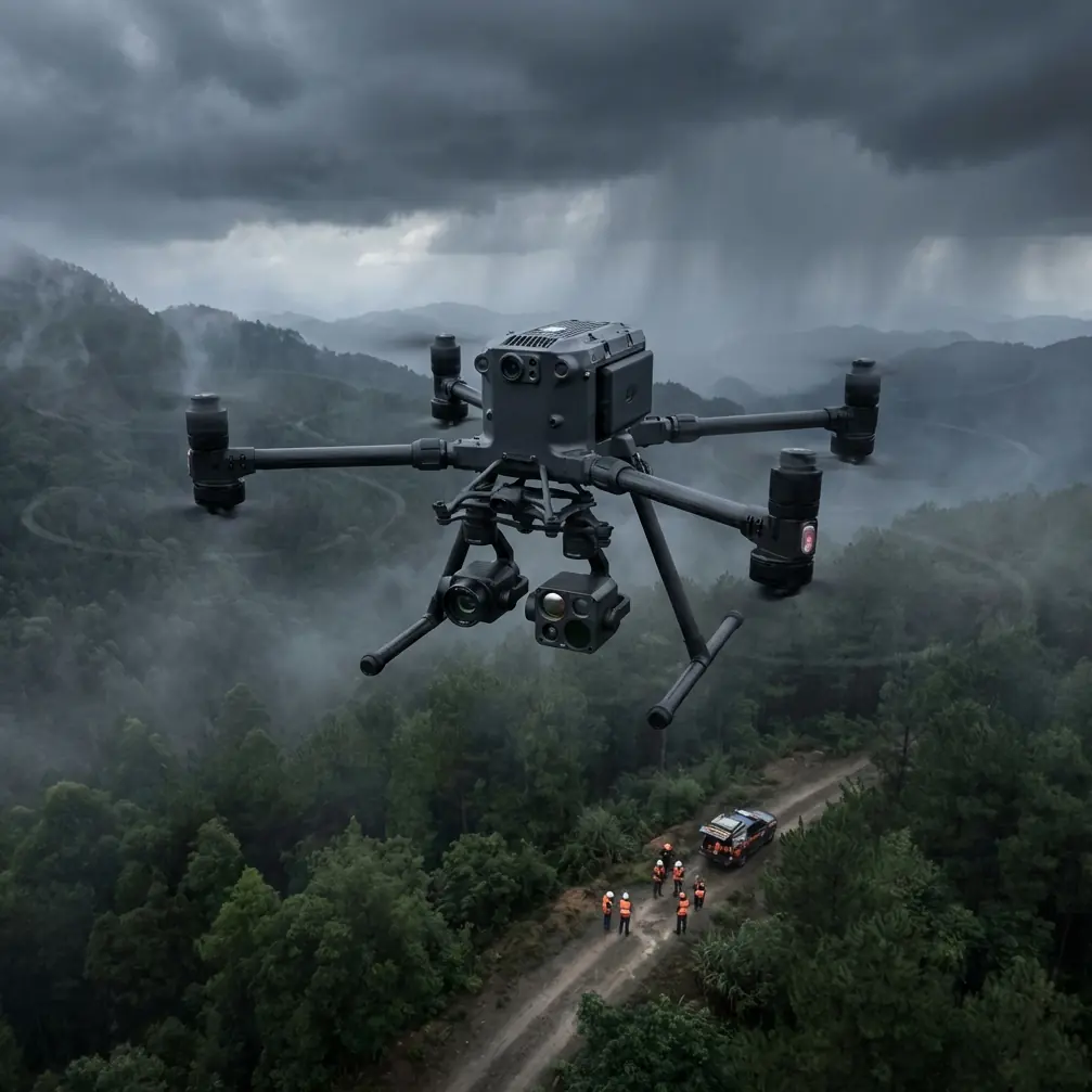
Matrice 400 in Mountain Forest Recon: A Field Report on Vibration, Ground Handling, and Getting Real Range
META: Specialist field report on using Matrice 400 for mountain forest scouting, covering antenna positioning, thermal signature workflows, structural vibration lessons, launch stability, O3 transmission, AES-256, hot-swap batteries, photogrammetry, GCP strategy, and BVLOS planning.
Mountain forest scouting looks simple from a distance. Put a capable aircraft in the air, run a grid, collect thermal and visual data, head home. In the field, it behaves nothing like that.
Dense canopy breaks line of sight. Ridge lines punish weak link budgets. Cold mornings change battery behavior. Uneven launch points expose every weakness in landing gear geometry and attitude estimation. If you are preparing a Matrice 400 deployment for forestry reconnaissance, habitat observation, infrastructure checks inside wooded terrain, or pre-survey route intelligence, the aircraft itself is only half the story. The other half is understanding the physics that quietly determines whether your data is clean, stable, and repeatable.
I want to frame this through two engineering ideas pulled from classical aircraft design references that still matter in multirotor field work. One comes from laminated structure vibration. The other comes from takeoff and landing ground-reaction modeling. Neither source mentions the Matrice 400 directly. Both are highly relevant when you are flying one in mountain forests.
Why structural vibration matters more in the woods than on open ground
One reference examines vibration behavior in laminated plates and states a clear trend: as laminate thickness increases, natural frequency rises roughly linearly, while modal damping is governed by layer angle and stacking-related parameters rather than thickness alone. It also notes that when the number of laminate plies increases under the same boundary conditions, stiffness grows faster than mass, so natural frequency trends upward.
That may sound abstract. It is not.
For a Matrice 400 mission over forests, especially when carrying a mixed payload set for thermal signature review and photogrammetry, you care deeply about how vibration moves through the airframe, payload bracket, and gimbal isolation system. In mountain air, the drone spends more time dealing with uneven rotor loading. One side of the aircraft may be in rising air while the other is being hit by a cross-slope gust curling over the canopy. If the structure and mounted payload system are excited near a problematic frequency band, you see it in three places immediately:
- thermal image shimmer at long focal lengths
- small but expensive photogrammetry alignment errors
- operator fatigue caused by over-correcting for what looks like unstable positioning
The old laminated-plate lesson is operationally significant because it reminds us that stiffness and damping are not interchangeable. A stiffer system can push natural frequencies upward, which is often beneficial, but damping behavior depends on configuration details, not just adding material. In drone terms, a “more solid” mounting approach is not always a “more stable” sensing approach.
If you are building out a Matrice 400 for mountain forest scouting, this affects payload rail choices, third-party mounting brackets, and even how you secure cable runs. A sloppy cable loop that taps a gimbal housing in gusts can create repeatable high-frequency contamination. The aircraft is powerful enough to keep flying well. Your dataset may not be.
A useful way to think about sensor configuration
The source plate example uses a 254 mm square laminate and compares layup patterns such as [±45], [±30], [0/90], and [±60]. One practical takeaway from that work is that directional stiffness changes vibration response. Translating that into Matrice 400 field practice: the orientation and support path of a mounted payload assembly matter.
In forest scouting, teams often prioritize the camera and forget the structure between the camera and the aircraft. That is backwards. If your thermal payload is mounted through a bracket with asymmetric compliance, the system may behave differently in lateral versus longitudinal gust loading. On a calm training field, you might never notice it. Over a tree line with rotor wash reflecting off a steep slope, you will.
This is why I advise crews to run two short validation flights before the first real mission of the day:
- a hover and yaw sweep at a fixed altitude over open ground
- a short transect parallel to the ridge you plan to inspect
Review thermal edges and still frames at full zoom. If the image defect only appears when tracking along one axis, suspect directional vibration or mounting asymmetry before blaming autofocus or the atmosphere.
Ground handling in uneven mountain launch zones
The second reference deals with aircraft ground reactions during takeoff and landing. The exact equations were written for conventional aircraft, but the engineering logic transfers neatly to heavy commercial drones operating from rough terrain.
The source describes an iterative method for solving ground normal reactions and pitch-moment balance. One detail stands out: when determining support reactions, aircraft attitude angle and vertical geometry are interdependent, so they must be solved through iteration until the difference between two successive estimates falls within the required precision. It also notes that in some calculations, small angular differences can be neglected, but only after understanding what those approximations do to the load path.
That is a direct warning for Matrice 400 crews launching from mountain clearings.
A lot of preventable mission issues begin before liftoff. The aircraft is placed on sloped soil, one leg settles slightly, the crew sees “good enough,” and proceeds. The flight controller may compensate. The camera may even stabilize. Yet the initial conditions already include an attitude bias and uneven support loading. For a mapping or thermal mission that depends on precise overlap, consistent nadir alignment, or clean baseline thermal comparisons, that bias can carry into the first minutes of the sortie.
The operational significance is simple: do not treat launch geometry as a cosmetic issue. Treat it as part of your measurement chain.
My field rule for mountain forest takeoff zones
Before the first launch, I check three things:
- whether the landing surface is compressible under one side of the aircraft
- whether a leg sits over roots, gravel voids, or wet organic soil
- whether the aircraft settles after motors arm but before takeoff
That last one is overlooked. In the reference, support reaction and attitude are linked. In drone practice, arming the motors can slightly alter how the aircraft seats itself on a marginal surface. If it settles, reset your visual check. If necessary, relocate the pad.
For crews doing photogrammetry with GCP-supported outputs, this matters more than many realize. A poor launch surface does not just affect takeoff elegance. It can introduce a subtle inconsistency in the initial climb and camera alignment sequence that complicates quality control later, especially when you are building a dense canopy-edge model where tie points are already limited.
Antenna positioning advice for maximum range in forested mountains
This is the question I get most often with Matrice-class aircraft: how do you preserve transmission range when terrain and trees are actively trying to ruin your link?
Start with the obvious but often ignored fact: your strongest transmission plan is a geometry plan, not a power plan.
If you are relying on O3 transmission in mountain forests, the control station should not be placed at the lowest convenient parking spot. It should be placed where the first third of the planned route has the cleanest possible line-of-sight corridor. I would rather walk an extra 200 meters uphill than spend the mission fighting partial masking through trunks and slope clutter.
Here is the antenna advice that consistently helps:
1. Present the antenna face, not the tip, toward the aircraft
Many crews still point antenna tips directly at the drone. That is usually wrong for panel-style or directional behavior assumptions. The strongest region is typically off the face or broadside geometry, not the end. Keep the aircraft in the intended radiation pattern, especially on outbound legs along a valley wall.
2. Avoid standing immediately beside vehicles, railings, or metal cases
In mountain staging areas, people cluster near the truck tailgate. Bad habit. Reflective clutter can distort near-field behavior and worsen multipath. Step away from metal surfaces before launch.
3. Raise the control position when the route drops behind partial canopy
Even an extra meter or two of operator elevation can help. A folding platform, stable berm, or naturally elevated knoll often improves signal continuity more than changing any software setting.
4. Rotate your body less than you rotate your station
Human bodies attenuate RF surprisingly well. If you are hand-holding the controller, constant body turns can create unnecessary blocking. Use a setup that keeps the antenna plane oriented deliberately.
5. Build the route so the aircraft never enters the first shadowed pocket at maximum distance
The first masked notch in a forested mountain route is where people discover whether their link margin was real or imagined. Cross it early at moderate distance, not at the farthest point.
For teams planning extended corridor work or BVLOS-authorized operations, transmission discipline matters as much as pilot skill. O3 helps, and AES-256 gives you confidence in protected data links, but neither one changes terrain physics. Range is won before takeoff through position, route design, and antenna orientation.
If you want a practical pre-mission checklist for this specific kind of setup, I usually share it directly with crews here: message me on WhatsApp.
Thermal scouting under canopy: what Matrice 400 crews should actually watch
Thermal signature work in forests is unforgiving. Canopy density, sun angle, moisture, and slope aspect all fight interpretation. The Matrice 400’s value is not merely staying airborne longer or carrying a serious sensor package. Its value is making repeatable collection possible when the target is intermittent and partially obscured.
For dawn wildlife-safe surveys, tree-stress detection, or search of hidden heat anomalies in vegetation corridors, vibration control and route consistency become tightly linked. Small oscillatory blur can soften thermal boundaries enough to make a cool branch cluster look like a diffuse heat source. That wastes interpretation time and increases false positives.
My recommendation is to separate thermal collection from photogrammetry unless your objective absolutely requires simultaneous capture. Thermal wants timing discipline and contrast awareness. Photogrammetry wants geometry discipline and overlap integrity. The Matrice 400 can support both workflows, but your mission design should respect their different tolerances.
For thermal-first sorties
- Fly earlier than you think, before sun loading flattens contrast.
- Use shorter reconnaissance legs at first to validate image steadiness over the exact canopy type.
- Re-fly suspect anomalies from a different heading to rule out branch occlusion or directional shimmer.
For mapping-first sorties
- Use GCPs where canopy openings permit, but do not overestimate what they can fix if your raw image set is unstable.
- Focus on clean overlap at the forest edge, access roads, ridgelines, and clearings where tie-point quality carries the model.
- Validate one section on site before committing the full area.
Hot-swap batteries are a workflow advantage, not just a convenience
In mountain forest operations, hot-swap batteries are less about saving seconds and more about preserving mission continuity. When conditions are changing quickly—fog lifting, thermal windows shrinking, wind shifting across a saddle—you do not want to power down, reboot, reinitialize, and re-stage unless necessary.
That continuity helps in two ways.
First, it keeps the crew mentally inside the same data-collection context. Second, it reduces the drift between successive flights when you are trying to compare thermal signatures or maintain consistent photogrammetry lighting. A platform that can turn around quickly is not just faster. It is scientifically cleaner when timing matters.
The deeper lesson from the references
The aircraft design sources point to something experienced drone teams eventually learn the hard way: performance does not come from a single spec sheet line.
From the laminated plate discussion, we get a reminder that vibration behavior depends on more than mass and thickness. Stiffness, damping, directional configuration, and boundary conditions all shape the result. For Matrice 400 operators, that means treating payload integration as an engineering problem, not a mounting accessory problem.
From the ground-reaction and pitch-balance discussion, we get a second reminder: support forces, geometry, and attitude influence one another. In the field, that means launch surface quality, aircraft seating, and pre-takeoff posture deserve the same seriousness as route planning.
Those details decide whether your mountain forest scouting mission produces confident answers or just attractive-looking files.
The Matrice 400 is at its best when the crew respects the entire chain: launch stability, transmission geometry, structural cleanliness, sensor discipline, and post-flight validation. In forests, every weak assumption gets exposed. That is exactly why a properly prepared team can outperform a more casually equipped one, even with the same aircraft.
Ready for your own Matrice 400? Contact our team for expert consultation.