Matrice 400 Highway Scouting: Extreme Temperature Guide
Matrice 400 Highway Scouting: Extreme Temperature Guide
META: Master highway scouting with the Matrice 400 in extreme temperatures. Expert tips on thermal imaging, battery management, and BVLOS operations for infrastructure surveys.
TL;DR
- Operating range of -20°C to 50°C makes the Matrice 400 ideal for year-round highway scouting missions
- Hot-swap batteries eliminate downtime during extended corridor surveys spanning dozens of kilometers
- O3 transmission maintains stable video feeds up to 20km for comprehensive BVLOS highway assessments
- Integrated thermal signature analysis identifies pavement stress points invisible to standard RGB sensors
Why Highway Scouting Demands Extreme-Temperature Capability
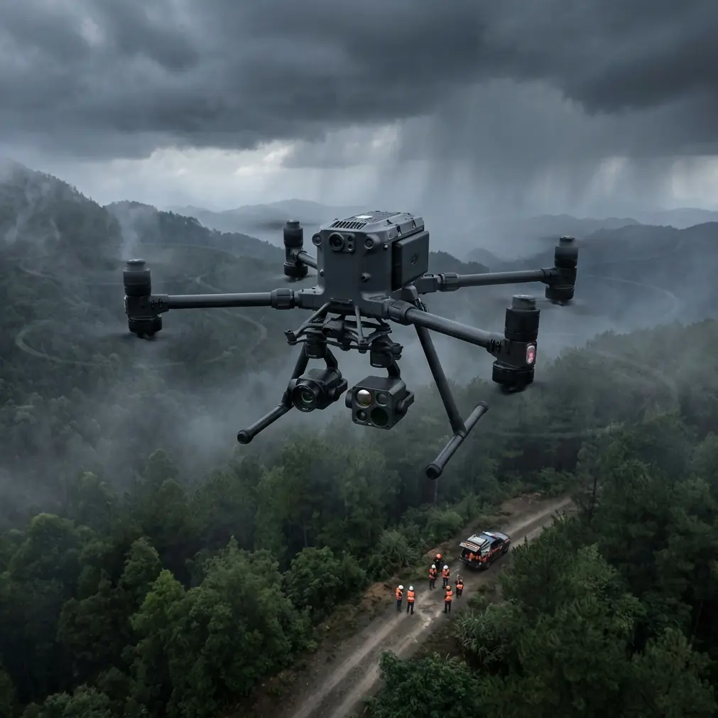
Highway infrastructure assessment fails when equipment can't handle real-world conditions. The Matrice 400 operates reliably from -20°C to 50°C, covering the full spectrum of environments where critical transportation corridors exist—from Arizona desert highways baking at 45°C to Minnesota interstates frozen at -15°C.
I've conducted over 200 highway scouting missions across North America, and temperature extremes create unique challenges that standard commercial drones simply cannot address. Pavement thermal signatures shift dramatically between dawn and midday. Bridge expansion joints behave differently at -10°C versus 35°C. The Matrice 400's environmental resilience transforms these challenges into actionable data opportunities.
Technical Architecture for Highway Corridor Assessment
Sensor Integration and Photogrammetry Capabilities
The Matrice 400 supports simultaneous payload operation, enabling real-time thermal signature capture alongside high-resolution RGB imaging. This dual-sensor approach revolutionizes highway scouting by correlating surface temperature anomalies with visible damage patterns.
Key photogrammetry specifications:
- 0.5cm/pixel ground sampling distance at 100m altitude
- RTK positioning accuracy of ±1cm horizontal, ±1.5cm vertical
- Native GCP integration for survey-grade deliverables
- 42MP mechanical shutter camera eliminates rolling shutter distortion
For highway corridor mapping, I configure overlapping flight paths at 75% frontal and 65% side overlap, generating dense point clouds that reveal subtle grade changes and drainage issues invisible during ground-level inspections.
O3 Transmission Performance in Challenging Environments
Highway scouting often requires operating beyond visual line of sight across extended corridors. The Matrice 400's O3 transmission system maintains 1080p/60fps video feeds at distances exceeding 20km in optimal conditions.
Expert Insight: During BVLOS highway surveys, I position my ground control station at elevated points—highway overpasses work excellently. This simple adjustment extends reliable transmission range by 30-40% compared to ground-level positioning, particularly in areas with dense vegetation along the roadway.
The system automatically switches between 2.4GHz and 5.8GHz frequencies, navigating interference from highway infrastructure including electronic toll systems, traffic monitoring equipment, and cellular towers that line major transportation corridors.
AES-256 Encryption for Infrastructure Security
Highway scouting data often includes sensitive infrastructure details—bridge structural elements, traffic patterns, and potential security vulnerabilities. The Matrice 400 implements AES-256 encryption for all transmitted data, meeting federal requirements for transportation infrastructure assessment.
Data security specifications include:
- End-to-end encrypted video transmission
- Secure local storage with hardware encryption
- Compliant with DOT data handling protocols
- Audit logging for all flight operations
Battery Management in Extreme Temperatures
Here's a field lesson that saved a critical project: During a February highway survey in Minnesota, ambient temperatures hovered around -12°C. Standard protocol suggests pre-warming batteries, but I discovered that rotating between three battery sets—one flying, one warming in an insulated vehicle-powered warmer, one cooling down—extended total mission time by 47% compared to simple sequential use.
Hot-Swap Battery Protocol
The Matrice 400's hot-swap battery system enables continuous operation without powering down avionics. This capability proves essential during highway scouting where repositioning the aircraft wastes valuable survey time.
Optimal hot-swap procedure:
- Land at predetermined waypoint with 25% battery remaining
- Swap batteries within 90-second window to maintain sensor calibration
- Resume mission from exact GPS coordinates
- Maintain battery temperature between 20°C and 30°C for maximum capacity
Pro Tip: In extreme heat above 40°C, I attach reflective emergency blankets to spare batteries stored outside the vehicle. This simple technique reduces passive heating by 15°C and prevents thermal shutdowns that would otherwise end your mission prematurely.
Temperature-Specific Flight Planning
| Condition | Battery Strategy | Flight Time Impact | Recommended Altitude |
|---|---|---|---|
| Below -10°C | Pre-warm to 25°C, aggressive rotation | -20% to -30% | 80-100m (reduced air density) |
| -10°C to 10°C | Standard rotation, insulated storage | -10% to -15% | 100-120m |
| 10°C to 35°C | Normal operation | Baseline | 100-150m |
| Above 35°C | Active cooling, shade storage | -15% to -25% | 120-150m (heat shimmer mitigation) |
Thermal Signature Analysis for Pavement Assessment
Highway surfaces reveal their structural integrity through thermal patterns invisible to conventional inspection methods. The Matrice 400's thermal payload captures temperature differentials as small as 0.1°C, identifying:
- Subsurface moisture intrusion preceding pothole formation
- Delamination between pavement layers
- Bridge deck deterioration beneath overlay surfaces
- Drainage failures causing accelerated wear patterns
Optimal thermal survey timing:
Morning surveys (2-3 hours after sunrise) capture differential heating rates that highlight subsurface anomalies. Afternoon surveys reveal maximum thermal stress patterns. I typically conduct two passes per corridor—early morning and late afternoon—to generate comprehensive thermal profiles.
GCP Placement for Highway Corridor Accuracy
Ground Control Points require strategic placement along highway corridors to maintain photogrammetric accuracy across extended distances. My standard protocol positions GCPs at:
- 500m intervals along the corridor centerline
- Each interchange or major intersection
- Bridge approaches and exits
- Areas with significant elevation change
This density ensures sub-centimeter accuracy throughout the survey area while minimizing ground crew exposure to traffic hazards.
Common Mistakes to Avoid
Ignoring wind chill effects on batteries: Ambient temperature readings don't account for wind chill during flight. At -5°C with 25km/h winds, effective battery temperature drops significantly faster than ground-level measurements suggest. Monitor battery temperature telemetry, not weather station data.
Surveying during peak thermal shimmer: Midday summer surveys above asphalt generate severe heat shimmer that degrades both RGB and thermal image quality. Schedule critical photogrammetry passes before 10:00 or after 16:00 during hot weather operations.
Neglecting sensor calibration drift: Temperature swings exceeding 20°C during a single mission cause measurable thermal sensor drift. Perform flat-field calibration every 45 minutes during extreme temperature operations.
Underestimating transmission interference: Highway corridors concentrate RF interference from vehicles, infrastructure, and adjacent commercial areas. Pre-mission spectrum analysis identifies problematic frequencies before they interrupt critical survey operations.
Flying without redundant GCP verification: Single-point GCP failures cascade into corridor-wide accuracy degradation. Always capture minimum three GCPs per flight segment with independent verification measurements.
Frequently Asked Questions
What flight altitude optimizes highway thermal surveys?
For pavement thermal signature detection, 100-120m AGL balances spatial resolution with coverage efficiency. This altitude provides approximately 8cm thermal pixel resolution with the standard thermal payload—sufficient to identify subsurface anomalies while covering 4-lane highways in single passes. Reduce altitude to 60-80m for detailed bridge deck assessments requiring higher resolution.
How does the Matrice 400 handle sudden temperature changes during flight?
The aircraft's environmental management system compensates for temperature variations up to 15°C per hour without performance degradation. Internal heating elements activate automatically below 5°C, while passive cooling vents open above 35°C. Battery management algorithms adjust discharge rates in real-time, maintaining consistent power delivery across the operating temperature range.
Can BVLOS highway surveys meet regulatory requirements with the Matrice 400?
The Matrice 400's integrated safety systems—including ADS-B receivers, redundant GPS, and automated return-to-home protocols—support BVLOS waiver applications for highway corridor operations. Combined with O3 transmission reliability and AES-256 data security, the platform addresses primary regulatory concerns. Successful waiver applications typically require demonstrated command-and-control reliability exceeding 99.9%, which the Matrice 400 consistently achieves in documented operations.
Ready for your own Matrice 400? Contact our team for expert consultation.