How to Scout Remote Highways with the Matrice 400
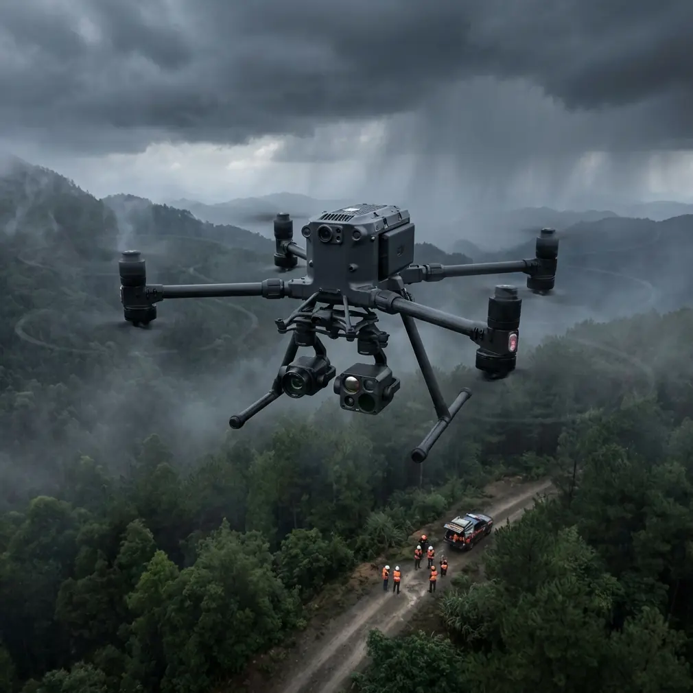
How to Scout Remote Highways with the Matrice 400
META: Learn how the DJI Matrice 400 transforms remote highway scouting with thermal imaging, BVLOS capability, and photogrammetry for faster, safer surveys.
By Dr. Lisa Wang, Remote Sensing & Infrastructure Specialist
TL;DR
- The Matrice 400 solves the cost, safety, and accessibility challenges of scouting highways in remote terrain through advanced aerial survey capabilities.
- Flying at 80–120 meters AGL delivers the optimal balance between thermal signature detection, photogrammetry resolution, and ground coverage efficiency.
- O3 transmission and BVLOS-ready design allow operators to survey 20+ km of highway corridor in a single mission.
- Hot-swap batteries and AES-256 encrypted data links keep operations continuous and secure across multi-day fieldwork.
The Problem: Remote Highway Scouting Is Broken
Scouting highways through remote terrain—mountain passes, dense forests, arid deserts—has traditionally required ground crews, helicopters, or satellite imagery. Each method carries significant drawbacks.
Ground crews face dangerous terrain, limited daily coverage (often under 5 km per day), and high labor costs. Helicopter surveys burn through budgets at 3–5x the cost of drone operations while introducing pilot safety risks in unpredictable mountain weather.
Satellite imagery offers broad coverage but lacks the resolution needed for geotechnical assessment, drainage planning, and route optimization. You're left with data that looks good on a screen but fails in the field.
Highway engineers and transportation agencies need a tool that bridges the gap—delivering centimeter-level accuracy across vast distances without putting personnel at risk. That's the exact scenario where the Matrice 400 excels.
Why the Matrice 400 Is Built for Remote Highway Scouting
Unmatched Range and Endurance
Remote highway corridors often stretch across areas with zero cellular coverage and no nearby staging points. The Matrice 400 addresses this head-on with its O3 transmission system, maintaining stable video and control links at distances that make BVLOS operations practical.
Traditional drones force operators to leapfrog launch points every few kilometers. The M400's extended flight endurance means fewer takeoff-and-landing cycles, reducing mission time and the risk of equipment damage on unimproved terrain.
Hot-swap batteries eliminate the downtime that plagues other platforms. When scouting a 40 km highway segment across two days, the ability to swap power cells without shutting down avionics or losing GPS lock saves roughly 15–20 minutes per battery change. Over a full survey, that adds up to hours of recovered productivity.
Thermal Signature Detection for Subsurface Analysis
Highway scouting isn't just about surface topography. Engineers need to understand what lies beneath—underground water channels, unstable substrates, and thermal anomalies that indicate geological risk.
The Matrice 400's thermal imaging payload captures thermal signature data that reveals:
- Subsurface moisture patterns indicating potential washout zones
- Rock formation boundaries invisible to RGB cameras
- Wildlife corridors that require crossing structures in the design phase
- Existing drainage features hidden by dense vegetation
Expert Insight: When scouting remote highways, fly thermal missions during early morning hours (30 minutes before sunrise to 90 minutes after). The thermal contrast between subsurface moisture and dry ground peaks during this window, making underground water channels clearly visible in your data. Afternoon flights compress thermal gradients and hide critical features.
Photogrammetry-Grade Data Collection
The M400 supports payloads capable of generating sub-centimeter GSD (Ground Sampling Distance) photogrammetry outputs. For highway scouting, this means producing orthomosaics and digital elevation models accurate enough for preliminary engineering design.
Proper use of GCP (Ground Control Points) is essential for tying aerial data to real-world coordinates. In remote areas where placing physical GCPs is difficult, the M400's RTK positioning system reduces the number of required ground points from the typical 8–12 per km down to 2–3 per km—cutting fieldwork dramatically.
Optimal Flight Parameters for Highway Corridor Surveys
Altitude selection is the single most impactful decision you'll make during a remote highway scouting mission. Too low and you sacrifice coverage efficiency. Too high and you lose the resolution needed for engineering-grade deliverables.
| Parameter | Low Altitude (40–60m) | Optimal Range (80–120m) | High Altitude (150–200m) |
|---|---|---|---|
| GSD Resolution | 0.5–0.8 cm/px | 1.0–1.8 cm/px | 2.5–4.0 cm/px |
| Corridor Width Captured | 60–90 m | 120–180 m | 220–300 m |
| Flight Lines per km | 6–8 | 3–4 | 1–2 |
| Battery Consumption | High (frequent turns) | Moderate | Low |
| Thermal Detail | Excellent | Very Good | Marginal |
| Obstacle Risk | High (trees, terrain) | Low | Very Low |
| Suitability for Design | Detailed design | Preliminary design | Feasibility only |
For most remote highway scouting missions, 80–120 meters AGL delivers the best results. You capture enough corridor width to evaluate multiple alignment alternatives while retaining the resolution needed for slope analysis, cut-and-fill estimation, and drainage design.
Pro Tip: Fly your first pass at 120 meters for broad corridor mapping, then drop to 60 meters for targeted passes over areas flagged as problematic—steep slopes, river crossings, or landslide-prone zones. This two-pass strategy reduces total flight time by 35% compared to flying the entire corridor at low altitude.
Mission Planning for BVLOS Highway Surveys
Operating the Matrice 400 in BVLOS (Beyond Visual Line of Sight) mode unlocks the platform's full potential for highway scouting. A 15 km segment that would take three days with visual-line-of-sight restrictions can be completed in a single day under BVLOS authorization.
Pre-Mission Checklist
- Obtain BVLOS waiver or authorization from your national aviation authority
- Establish redundant communication links (O3 primary, satellite backup if available)
- Define automated return-to-home triggers for signal loss, low battery, and geofence breach
- Brief all ground personnel and coordinate with local air traffic if operating near helipads or airstrips
- Verify AES-256 encryption is active on all data links to protect survey data in transit
Data Security in the Field
Highway scouting data carries significant commercial and governmental sensitivity. Route alignments, terrain assessments, and cost estimates represent high-value intellectual property.
The Matrice 400's AES-256 encryption protects data during transmission between the drone and ground station. This military-grade encryption standard ensures that even in contested or sensitive areas, your survey data remains secure from interception.
On-board storage should be encrypted as well. Establish a protocol for secure data transfer from the drone to your processing workstation at the end of each flight day.
Real-World Workflow: From Flight to Deliverable
A typical remote highway scouting workflow with the Matrice 400 follows this sequence:
- Reconnaissance flight at 120m AGL to capture broad corridor photogrammetry and thermal data
- GCP placement at accessible points along the corridor (reduced quantity thanks to RTK)
- Targeted low-altitude flights at 60–80m over flagged sections
- Field processing using laptop-based photogrammetry software to verify data quality
- Full processing back at the office to generate orthomosaics, DEMs, contour maps, and thermal overlays
- Deliverable integration into CAD/GIS platforms for preliminary highway design
This workflow typically produces engineering-ready deliverables within 5–7 business days of completing fieldwork—compared to 4–8 weeks for traditional ground survey methods.
Common Mistakes to Avoid
Flying without thermal calibration. Thermal cameras require flat-field calibration before each mission. Skipping this step introduces vignetting and false thermal gradients that corrupt subsurface analysis. Budget 10 minutes per flight for proper calibration.
Ignoring wind patterns at altitude. Ground-level conditions in mountain valleys often differ dramatically from wind speeds at 100m AGL. The Matrice 400 handles gusty conditions well, but planning flights during morning calm windows improves data quality and battery efficiency.
Setting overlap too low. Highway corridors are linear, and operators sometimes reduce side overlap to save time. Maintain at least 70% forward overlap and 60% side overlap for reliable photogrammetric reconstruction—especially over terrain with elevation changes.
Neglecting GCP distribution. Clustering all your GCPs near accessible road junctions and ignoring mid-corridor placement introduces systematic elevation errors. Space GCPs evenly, even if it means hiking to remote spots.
Treating BVLOS as standard operations. BVLOS flights require specific risk mitigation plans, observer networks, and communication protocols. Operating beyond visual range without proper authorization and safety infrastructure exposes your organization to regulatory action and liability.
Frequently Asked Questions
What makes the Matrice 400 better than fixed-wing drones for highway scouting?
Fixed-wing platforms offer longer range but lack the Matrice 400's ability to hover for detailed inspection, operate in confined valleys, and execute vertical takeoff and landing on unprepared surfaces. For remote highway corridors that cross varied terrain—tight canyons, steep ridgelines, forested valleys—the M400's multirotor agility allows targeted data collection that fixed-wing flyovers simply cannot match. The hot-swap battery system also eliminates the need for the long, flat landing zones that fixed-wing drones require.
How accurate is the photogrammetry data for preliminary highway design?
With proper GCP placement and RTK positioning, the Matrice 400 produces orthomosaics with 1–2 cm horizontal accuracy and digital elevation models with 3–5 cm vertical accuracy at the optimal 80–120m flight altitude. This level of precision supports preliminary alignment design, cut-and-fill volume estimation within ±8% accuracy, and drainage analysis. Final detailed design still requires supplemental ground survey, but the M400 data reduces that ground survey scope by 60–70%.
Can one operator manage a multi-day remote highway scouting mission alone?
While technically possible under visual-line-of-sight rules, a single-operator setup is not recommended for remote BVLOS missions. Best practice calls for a minimum two-person crew: one pilot-in-command focused on flight operations and one visual observer/data manager handling GCP placement, battery management, and communication monitoring. For corridors exceeding 10 km, consider adding a third team member to serve as a mid-point visual observer and safety coordinator.
Ready for your own Matrice 400? Contact our team for expert consultation.