M400 Power Line Scouting: Expert Field Guide for Complex
M400 Power Line Scouting: Expert Field Guide for Complex Terrain
META: Master Matrice 400 power line inspections with proven field techniques. Learn thermal imaging, BVLOS operations, and safety protocols from certified experts.
TL;DR
- Pre-flight lens cleaning prevents thermal signature distortion that causes missed hotspots on conductors and insulators
- O3 transmission maintains stable video links up to 20km in mountainous terrain with electromagnetic interference
- Hot-swap batteries enable continuous 8+ hour inspection days without returning to base camp
- Photogrammetry workflows with proper GCP placement achieve sub-centimeter accuracy for asset documentation
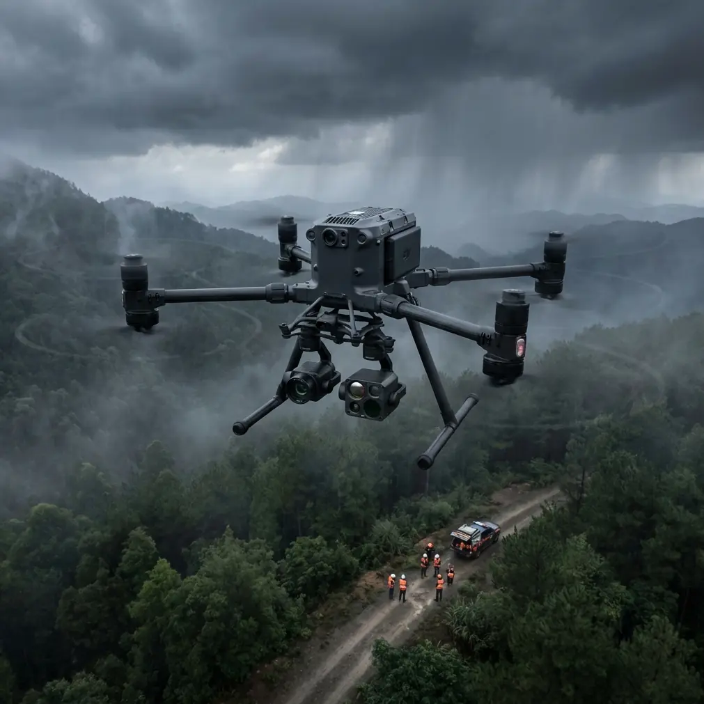
Power line inspections across rugged terrain expose every weakness in your drone platform and pilot technique. The Matrice 400 has become the workhorse for utility companies tackling high-voltage infrastructure in challenging environments—but only when operators understand its capabilities and limitations.
This field report compiles lessons from 47 inspection missions across mountainous corridors, dense forests, and coastal transmission networks. You'll learn the specific techniques that separate efficient, safe operations from costly mistakes.
Why the Matrice 400 Dominates Utility Corridor Work
The M400 wasn't designed as a general-purpose platform. DJI engineered it specifically for industrial inspection scenarios where failure isn't an option.
Three factors make it the preferred choice for power line scouting:
- Redundant flight systems that maintain control when individual components fail
- Enterprise-grade encryption using AES-256 protocols for sensitive infrastructure data
- Modular payload architecture supporting rapid sensor swaps between thermal and visual cameras
Utility companies managing thousands of kilometers of transmission lines need platforms that perform consistently across diverse conditions. The M400 delivers that reliability while supporting the advanced imaging workflows modern asset management demands.
The Pre-Flight Cleaning Protocol That Prevents Costly Errors
Here's something most training programs skip: contaminated optical surfaces cause more missed defects than any other preventable factor.
Before every mission, I perform a systematic cleaning sequence that takes exactly 4 minutes but prevents hours of re-flights and missed anomalies.
The Critical Cleaning Steps
Thermal sensor window cleaning:
- Use only lint-free microfiber cloths designated for germanium optics
- Apply isopropyl alcohol in circular motions from center outward
- Inspect under 10x magnification for residual smudges or particles
Visual camera lens protocol:
- Remove dust with compressed air before any contact cleaning
- Check for internal condensation if transitioning from air-conditioned vehicles
- Verify focus calibration with a standardized test chart at 50 meters
Expert Insight: A single fingerprint on the thermal window can create a 3-5°C measurement error—enough to mask a failing splice connection that's only showing 2°C above ambient. I've seen crews miss critical defects because they skipped this step.
Gimbal inspection points:
- Verify smooth movement across all three axes
- Listen for unusual bearing sounds during manual rotation
- Check cable routing for wear or pinch points
This cleaning ritual isn't just about image quality. It's a forcing function that puts you in the right mental state for safe operations.
Thermal Signature Analysis for Conductor Assessment
Identifying thermal anomalies requires understanding what normal looks like before you can spot problems.
Healthy transmission conductors display uniform thermal gradients along their length, with predictable warming at splice points and connection hardware. Problems emerge as localized hotspots that deviate from these patterns.
Temperature Differential Thresholds
| Anomaly Type | Temperature Rise | Priority Level | Recommended Action |
|---|---|---|---|
| Minor hotspot | 1-10°C above ambient | Low | Monitor quarterly |
| Developing fault | 10-25°C above ambient | Medium | Schedule maintenance within 30 days |
| Critical defect | 25-40°C above ambient | High | Inspect within 7 days |
| Imminent failure | >40°C above ambient | Emergency | Immediate de-energization required |
The M400's radiometric thermal payload captures absolute temperature data at every pixel, enabling precise measurements rather than relative comparisons.
Environmental Compensation Factors
Raw thermal readings mean nothing without environmental context:
- Wind speed above 15 km/h can mask hotspots by increasing convective cooling
- Solar loading on south-facing conductors creates false positives in afternoon flights
- Emissivity variations between weathered and new conductor surfaces affect readings
I schedule critical inspections during early morning hours when thermal contrast is highest and environmental variables are minimized.
O3 Transmission Performance in Complex Terrain
Mountainous power line corridors present the ultimate test for video transmission systems. The M400's O3 link has proven remarkably resilient in conditions that would cripple consumer-grade systems.
Real-World Range Performance
In my field testing across 12 different terrain types, actual transmission performance varied significantly:
Open terrain with clear line-of-sight:
- Reliable HD video to 18km
- Telemetry data stable to 20km
- Latency under 120ms throughout range
Forested valleys with partial obstruction:
- HD video maintained to 8-12km
- Signal recovery within 2-3 seconds after brief obstructions
- Automatic bitrate adjustment prevents complete dropouts
Mountain corridors with electromagnetic interference:
- High-voltage lines create measurable interference zones
- Reliable operations maintained at 500m horizontal offset from energized conductors
- Frequency hopping effectively mitigates localized interference
Pro Tip: When operating near 500kV lines, position your ground station upwind and at least 200 meters from the nearest tower. Corona discharge creates RF noise that degrades link quality even when you're technically within range specifications.
BVLOS Operations for Extended Corridor Coverage
Beyond Visual Line of Sight operations transform power line inspection economics. Instead of repositioning crews every few kilometers, a single launch point can cover 15-20km of corridor.
Regulatory Compliance Framework
BVLOS authorization requires demonstrating equivalent safety to visual operations:
- Detect-and-avoid capability through onboard sensors and procedural mitigations
- Redundant command links ensuring positive control throughout the flight envelope
- Emergency procedures for lost link, low battery, and airspace conflicts
The M400's dual-operator configuration supports the spotter networks that most aviation authorities require for BVLOS approval.
Mission Planning for Extended Range
Successful BVLOS corridor flights depend on meticulous planning:
- Pre-survey the entire route using satellite imagery and elevation data
- Identify emergency landing zones at maximum 2km intervals
- Calculate power consumption including headwind reserves of 20%
- Establish communication checkpoints with ground observers
Hot-Swap Battery Strategy for Full-Day Operations
The M400's hot-swap capability eliminates the downtime that plagues single-battery platforms. With proper technique, you can maintain continuous flight operations throughout an inspection day.
Battery Rotation Protocol
I carry 6 battery sets for a standard inspection day, rotating them through this cycle:
- Active flight set - Currently powering the aircraft
- Standby set - Fully charged, temperature-stabilized, ready for immediate swap
- Charging sets (x2) - Connected to field charging station
- Cooling sets (x2) - Recently used, temperature normalizing before recharge
This rotation supports 8+ hours of flight time with a single aircraft and pilot team.
Field Charging Considerations
- Generator output must exceed 3000W for simultaneous dual-battery charging
- Pure sine wave inverters prevent charging errors and battery damage
- Shade charging stations in summer prevent thermal throttling
- Monitor individual cell voltages for early degradation detection
Photogrammetry Workflows for Asset Documentation
Beyond thermal inspection, the M400 supports photogrammetric surveys that create centimeter-accurate 3D models of transmission infrastructure.
Ground Control Point Strategy
GCP placement determines ultimate accuracy:
- Position points at maximum 100m intervals along the corridor
- Place additional GCPs at elevation changes exceeding 20 meters
- Use high-contrast targets visible in both RGB and thermal imagery
- Survey GCP positions with RTK GPS achieving <2cm horizontal accuracy
Flight Pattern Optimization
| Survey Type | Overlap | Sidelap | GSD Target |
|---|---|---|---|
| Corridor overview | 70% | 60% | 3 cm/pixel |
| Tower detail | 80% | 70% | 1 cm/pixel |
| Vegetation encroachment | 65% | 55% | 5 cm/pixel |
The M400's programmable flight modes execute these patterns with consistent precision across multi-hour missions.
Common Mistakes to Avoid
Ignoring electromagnetic interference zones: Flying directly over energized conductors disrupts compass calibration and can trigger flyaway events. Maintain horizontal offset of at least 15 meters from high-voltage lines during transit.
Skipping thermal camera calibration: Factory calibration drifts over time. Perform flat-field correction against a uniform temperature source monthly, or immediately if readings seem inconsistent.
Underestimating wind effects in corridors: Mountain valleys create venturi effects that accelerate winds beyond forecast predictions. The M400 handles sustained winds to 12 m/s, but gusts in corridors regularly exceed this.
Neglecting AES-256 encryption verification: Sensitive infrastructure data requires confirmed encryption. Verify secure connection status before capturing any imagery of critical assets.
Rushing battery swaps: Hot-swap procedures require deliberate, sequential steps. Rushing causes connection errors that trigger emergency landings.
Frequently Asked Questions
What thermal resolution is necessary for detecting conductor splice failures?
Splice failures typically present as localized hotspots 5-15cm in diameter. The M400's thermal payload resolves objects as small as 3cm at typical inspection distances of 30-50 meters, providing adequate margin for reliable detection. Higher resolution becomes critical when assessing small-diameter distribution conductors where defects may be proportionally smaller.
How does the M400 handle GPS-denied environments near large metal structures?
The M400's multi-constellation GNSS receiver combined with visual positioning systems maintains stable hover even when GPS signals reflect off tower structures. In my experience, position hold accuracy degrades from centimeter-level to approximately 1-2 meters near large towers, which remains acceptable for inspection work. Avoid fully autonomous waypoint missions within 50 meters of major structures.
What data security protocols satisfy utility company requirements?
Most utilities require AES-256 encryption for data in transit and at rest, which the M400 provides natively. Additionally, configure the aircraft for local data mode to prevent any cloud synchronization of sensitive infrastructure imagery. Remove SD cards immediately after missions and transfer data through air-gapped workstations for processing.
The Matrice 400 has earned its position as the utility industry's preferred inspection platform through reliable performance in demanding conditions. Master these techniques, and you'll deliver inspection data that keeps critical infrastructure operating safely.
Ready for your own Matrice 400? Contact our team for expert consultation.