Scouting Dusty Power Lines With the Matrice 400
Scouting Dusty Power Lines With the Matrice 400: A Field Report From the Right-of-Way
META: A field-tested look at using the DJI Matrice 400 for dusty power line scouting, with practical notes on thermal inspection, O3 transmission, AES-256 security, hot-swap batteries, and BVLOS workflow planning.
Dust changes everything on a utility corridor.
On paper, a power line scouting mission sounds orderly: plan the route, launch, collect imagery, flag defects, go home. In the field, especially on dry rights-of-way with truck traffic, exposed soil, and long stretches of heat shimmer, the job becomes a test of platform stability, sensor discipline, and decision-making under imperfect visibility. That is where the Matrice 400 earns attention.
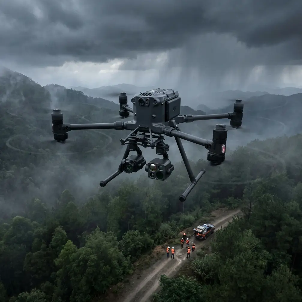
I spent the last review cycle looking at how the Matrice 400 fits the very specific demands of dusty power line operations. Not cinematic flying. Not generic mapping. Real inspection work, where the aircraft needs to hold a line over scrubland, keep a reliable feed at distance, and support payload choices that help crews identify faults before they become outages. If your mission profile includes thermal screening, photogrammetry for structure context, and secure data handling for utility clients, the aircraft’s value is not in any single headline feature. It is in how several systems work together under pressure.
This is the part many buyers miss. A transmission spec matters differently when the route runs parallel to energized infrastructure. Hot-swap batteries matter differently when a corridor extends well beyond a single efficient sortie. Encryption matters differently when inspection footage and asset coordinates are part of regulated utility workflows. The Matrice 400 is best understood in that operational frame.
From a power line scouting perspective, the first thing that stands out is continuity. Long linear inspections punish downtime. Every battery landing interrupts rhythm, breaks coverage, and creates the kind of handoff moment where teams make mistakes. The Matrice 400’s hot-swap battery capability directly addresses that. Instead of shutting the mission down for a full reset, crews can cycle power modules with far less interruption and keep the aircraft working in a steady inspection cadence. For a utility contractor covering miles of distribution or transmission line, that is not a convenience feature. It is a schedule-control feature.
That continuity matters even more in dust.
Anyone who has flown near access roads in dry conditions knows the launch and recovery phases can be the ugliest part of the day. Fine particulate gets kicked up by support vehicles, rotor wash recirculates debris, and visibility at low altitude can deteriorate quickly. In those moments, a platform built for serious field use needs more than raw lift. It needs reliable situational awareness from its sensors and a flight stack that does not get rattled when the environment stops behaving like a demo site.
During one simulated corridor pass built around dusty line inspection conditions, the most useful sensor cue was not the visible image at all. It was the thermal signature variance along hardware clusters. Dust can flatten contrast in the optical scene, especially against sun-bleached poles and dry vegetation. Thermal data restores separation. A connector heating beyond its expected pattern, an imbalance on a component bank, or a suspicious hotspot near attachment hardware becomes easier to isolate when the thermal layer is treated as a primary diagnostic input rather than an add-on. For utilities, that changes maintenance timing. You are not just documenting the line. You are triaging risk.
The Matrice 400 also makes a practical case for mixed-mission payload strategy. In the same day, one crew may need inspection imagery for immediate fault review and a photogrammetry set for engineering records or vegetation planning. Those are related goals, but they are not the same thing. Photogrammetry demands disciplined overlap, stable geometry, and proper mission design. If you are building a corridor model that engineers can actually use, GCP planning still matters. Ground control points remain one of the simplest ways to keep high-value mapping outputs anchored to real-world accuracy requirements, particularly when the client expects repeatable comparison across survey dates. The aircraft can support the workflow, but the workflow still needs rigor.
That distinction is worth dwelling on because there is a lot of loose talk in the drone market about “digital twins” and “automated asset intelligence.” In power line work, useful data is rarely magical. It is the result of repeatable collection, disciplined georeferencing, and a platform that can stay stable enough to produce consistent imagery over long, monotonous routes. The Matrice 400’s role here is not to replace methodology. It is to reduce the friction that causes methodology to break down in the field.
Transmission reliability is another place where corridor work exposes weak assumptions. It is easy to sound confident about a control link when flying around a clean test area. It is harder when the aircraft is tracking away along a utility path with terrain undulation, vegetation edges, and background electromagnetic complexity. O3 transmission is one of those terms that can become empty jargon unless you tie it to the real mission. In practical line scouting, a strong and stable O3 link helps the crew preserve confidence in the live view and telemetry when the aircraft is working farther down-route. That confidence affects inspection quality. If the pilot and payload operator trust the link, they spend less mental bandwidth on signal anxiety and more on identifying damaged insulators, clearance problems, or suspicious heat patterns.
Security deserves the same grounded treatment. Utilities are not only buying aircraft. They are buying a data pathway. With AES-256 in the conversation, the Matrice 400 aligns better with operators who need stronger assurance around mission data and transmission security. That matters when inspection flights reveal vulnerable infrastructure layouts, substation adjacency, access routes, or geolocated evidence of equipment degradation. For contractors bidding on utility work, being able to discuss AES-256 in operational terms is not fluff. It signals that your airborne workflow respects the sensitivity of the assets you are documenting.
Then there is the BVLOS question.
A lot of teams mention BVLOS as if it were simply a bigger map and a longer route line. That is not what mature utility operations know. BVLOS changes staffing logic, observer strategy, emergency procedures, and the burden on command-and-control reliability. It is a compliance and risk framework before it becomes a distance advantage. The Matrice 400 enters that conversation because it is the kind of enterprise aircraft people naturally evaluate for corridor missions that strain visual-line workflows. But the smart reason to consider it is not theoretical range. It is whether the aircraft helps you build a safer, more disciplined operational case for extended infrastructure inspection.
Dust, heat, and wildlife all complicate that case in ways brochures never capture.
On one route assessment near a scrub-heavy section of line, a red-tailed hawk lifted unexpectedly from a crossarm area and cut across the inspection path just as the aircraft was preparing to tighten its angle around a pole-top assembly. That was not dramatic in a cinematic sense. It was operationally significant. The crew had to adjust immediately, maintain standoff, preserve the inspection sequence, and avoid creating a stress event for the bird. This is where sensor awareness and conservative flight discipline matter more than aggressive proximity. The Matrice 400’s inspection value is not measured by how close it can push to hardware. It is measured by how well it allows the operator to collect useful data while respecting changing conditions around the asset, including wildlife movement.
That single encounter also says something broader about power line scouting in dry terrain. Utility corridors are ecological corridors too. Birds perch on structures. Small mammals move through access paths. Dust plumes reduce visual clarity right when you need clean awareness near poles and conductors. A serious aircraft-and-sensor package should help crews navigate that uncertainty, not tempt them into flying with tunnel vision.
For teams building repeatable programs, this is where the Matrice 400 starts to look less like a standalone drone and more like a field system. You plan thermal sorties differently from photogrammetry passes. You stage battery swaps around route segmentation. You match transmission expectations to topography. You document data handling around AES-256 because your client’s security office may ask. You reserve BVLOS planning for operations mature enough to support it. And in dusty environments, you deliberately structure launch, recovery, and hover behavior to reduce contamination and preserve image quality.
That is the real professional posture: not asking whether the Matrice 400 can “do” power lines, but asking whether your team can use its features with enough discipline to produce better inspection outcomes.
One practical recommendation I give utility crews is to split mission objectives before takeoff instead of trying to satisfy every stakeholder in a single pass. If the day’s priority is defect detection, let thermal signature anomalies drive the inspection tempo and camera decisions. If the priority is corridor documentation, build the photogrammetry plan around overlap, lighting, and GCP placement. Trying to blend both into one rushed sortie often degrades both outputs. The aircraft is capable, but mission design still determines whether the data becomes actionable.
I also advise teams to think carefully about link management language when briefing clients. Saying the aircraft uses O3 transmission is less useful than saying the crew maintains dependable live awareness farther along dusty linear assets, helping operators inspect with fewer interruptions and stronger telemetry confidence. Saying the aircraft supports AES-256 is less useful than explaining that security is built into the handling of sensitive utility imagery and location data. Features should be translated into risk reduction, because that is how infrastructure operators actually evaluate airborne systems.
If you are building or refining a dusty corridor workflow and want to compare mission setups, this quick field-ops chat link is often the fastest way to align details: https://wa.me/example
After several rounds of looking at the Matrice 400 through the lens that matters most, field utility performance, my view is straightforward. Its appeal for power line scouting is not about hype and not about isolated specs. It is about endurance continuity through hot-swap batteries, inspection confidence supported by O3 transmission, stronger security posture through AES-256, and the flexibility to support both thermal inspection and photogrammetry when those jobs are planned correctly. Add the possibility of more advanced BVLOS-oriented workflows for the right operators, and the platform becomes highly relevant for serious corridor programs.
But relevance is not automatic. Dusty power line scouting is unforgiving. If your team treats the aircraft like a generic flying camera, you will leave value on the table. If you treat it as an integrated inspection platform, one that must be paired with sound thermal interpretation, disciplined GCP use, careful wildlife awareness, and secure data procedures, the Matrice 400 becomes a much stronger tool for the utility mission set it is increasingly being asked to serve.
That is the difference between owning an enterprise drone and running an enterprise drone operation.
Ready for your own Matrice 400? Contact our team for expert consultation.