Matrice 400 for High-Altitude Power Line Scouting: Range
Matrice 400 for High-Altitude Power Line Scouting: Range, Antennas, Thermal Workflows, and Practical Field Setup
META: Specialist tutorial on using Matrice 400 for high-altitude power line scouting, with antenna positioning advice, thermal inspection workflow, photogrammetry planning, O3 transmission strategy, AES-256 security, and hot-swap battery field tips.
By Dr. Lisa Wang
High-altitude power line scouting is not a normal drone job with a mountain view. Air density shifts, ridgeline interference, cold-soaked batteries, and long linear inspection corridors all conspire to expose weak planning. If your platform, payload strategy, and link management are not thought through before takeoff, the aircraft may still fly well enough, but the data quality suffers first. That is usually where the real cost appears.
The Matrice 400 sits in an interesting position for this kind of work. Readers looking at this aircraft are usually not asking whether it can get airborne. They are asking whether it can maintain dependable transmission over terrain, whether it can support thermal signature analysis without compromising visual context, and whether it can keep a corridor mission moving without wasting half the day on battery handling. That is the right set of questions.
This tutorial is built around that exact scenario: scouting power lines in high-altitude terrain, with a special focus on antenna positioning for maximum range, plus the workflow decisions that matter when your objective is actionable inspection data rather than a scenic flight.
What changes at altitude
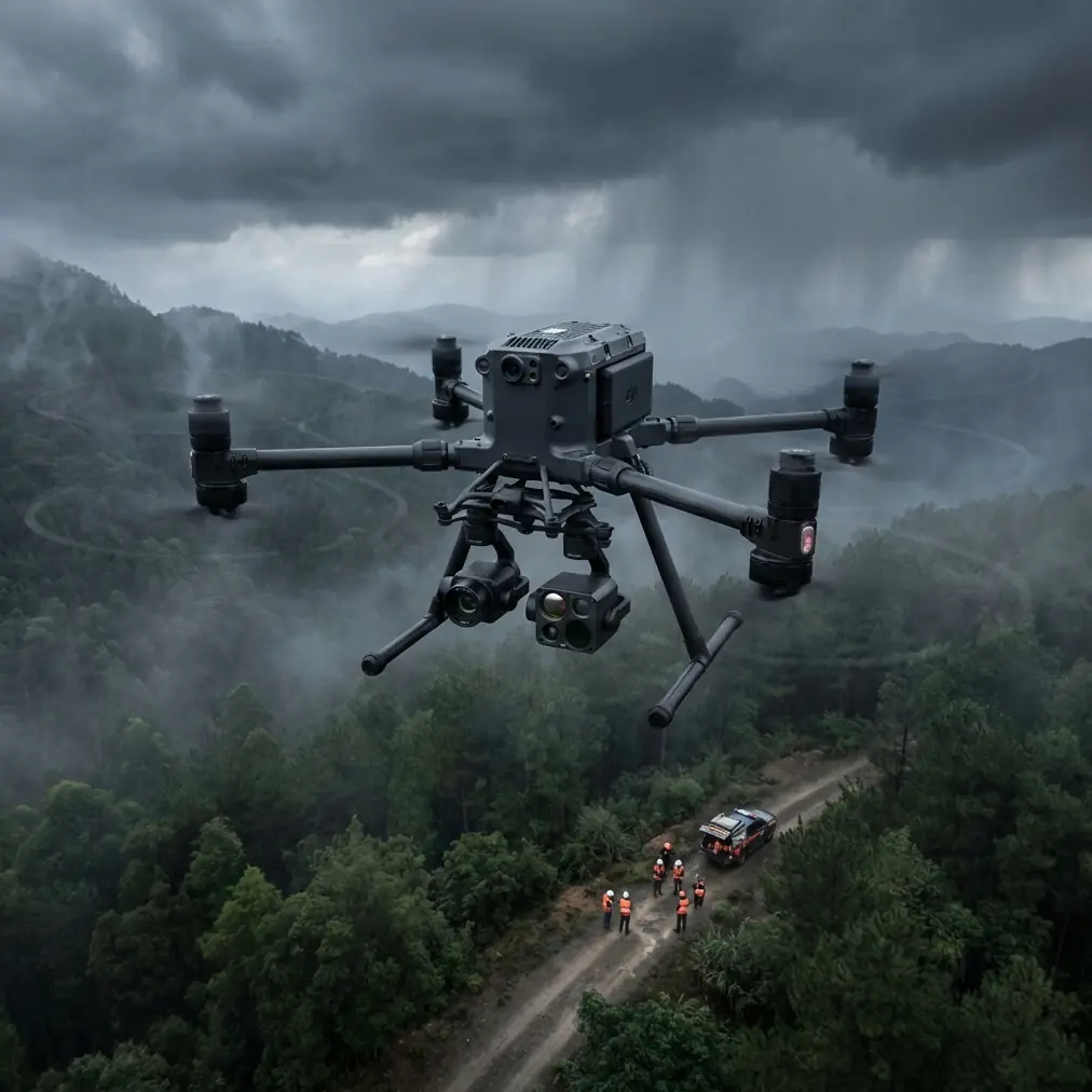
Power infrastructure in mountain environments creates a layered problem. Transmission towers are often positioned along ridges, in narrow valleys, or across slopes that interfere with both line of sight and radio propagation. The inspection target is long and thin, not compact. That means your flight path is rarely optimized for ideal signal geometry. You are following assets, not flying wherever RF conditions are easiest.
At altitude, wind gradients can also be deceptive. Conditions near launch may look calm while the route over a saddle or exposed span is substantially rougher. Even when the aircraft remains stable, your camera dwell time over insulators, clamps, jumpers, and connection points may be shortened by more frequent course corrections. Thermal interpretation becomes harder when image consistency varies from one section of the route to the next.
This is why the Matrice 400 conversation should not begin with raw endurance claims. It should begin with mission continuity. Two features matter especially in that context: long-range transmission architecture and hot-swap batteries. The first helps preserve control and video confidence over uneven terrain. The second reduces the operational friction of running multiple sequential sorties in thin air and low temperatures.
Why O3 transmission matters more in mountains than on flatland jobs
For high-altitude line scouting, a stable transmission system is not just about convenience for the pilot. It shapes inspection quality. DJI’s O3 transmission ecosystem is relevant here because mountain utility work often introduces partial obstructions, inconsistent line of sight, and variable multipath reflections from rock faces or metal structures. When the image feed degrades, the pilot becomes conservative, the camera operator loses confidence in defect confirmation, and the team may skip details they would normally collect.
That is also where the human factor comes in. A lot of teams assume “maximum range” is mostly a spec-sheet issue. In real operations, antenna orientation is often the deciding factor between a clean link and a frustrating one.
Antenna positioning advice for maximum practical range
This is the field habit I teach first: stop pointing the tips of the antennas at the aircraft.
Many pilots do this unintentionally, especially when the aircraft is climbing away along a steep power corridor. They visually “aim” the controller at the drone. That feels intuitive. It is also usually wrong. The strongest portion of the antenna radiation pattern is generally broadside, not off the tip. In practice, you want the flat face or side of the active antenna pattern presented toward the aircraft’s expected position, not the narrow end.
For high-altitude scouting, that translates into a few practical rules:
Keep the controller high and unobstructed. Your own body, a vehicle roof, a metal handrail, or a rock outcrop can degrade signal more than crews expect. Stand where the controller has the clearest possible path into the valley or along the ridgeline.
Match antenna tilt to aircraft elevation. If the Matrice 400 is significantly above you on a slope, a purely vertical antenna posture may not be optimal. Adjust so the broadside of the antenna pattern faces the aircraft’s actual position in three-dimensional space.
Avoid over-rotating while panning with the aircraft. Constantly chasing the drone with exaggerated wrist movement can create needless pattern misalignment. Smooth, moderate corrections are better.
Reposition the ground crew before the link becomes marginal. On linear utility routes, it is often smarter to leapfrog launch points than to squeeze every last meter from one location.
Use terrain logic, not just distance logic. A drone 2 km away with a clean line over an open ridge can be easier to maintain than one much closer but tucked behind a terrain shoulder.
These points sound simple because they are. Yet on difficult mountain jobs they often separate a professional operation from a stressed one. O3 transmission can give you the technical foundation, but field discipline is what turns that capability into usable range.
Security matters when inspection data is sensitive
Power line scouting is a civilian infrastructure task, but that does not mean the data is casual. Imagery of transmission assets, route conditions, access points, and maintenance issues can be operationally sensitive for utility owners and contractors. That makes AES-256 relevant in a very practical way.
Teams sometimes treat link encryption as a background feature. It is more than that. When you are transmitting inspection video and metadata from critical energy infrastructure, strong encryption supports client trust and internal compliance expectations. It also matters in multi-stakeholder projects where network security standards are scrutinized before a drone program is approved for regular deployment.
In other words, AES-256 is not just a checkbox. It helps the Matrice 400 fit into serious enterprise inspection environments where procurement and operations need to align.
Thermal signature collection: where scouting becomes diagnosis
Visual scouting can tell you a lot. Thermal work tells you what is changing under load.
On high-altitude power routes, thermal signature analysis is especially useful for finding abnormal heat patterns in connectors, splices, insulators, or other components that may not present obvious visual damage from a standoff distance. The challenge is that thermal data is easy to collect badly. Cold ambient conditions, shifting wind, changing sun angle, and inconsistent standoff distance can all distort interpretation.
With the Matrice 400, the value is not merely that it can support a thermal-capable inspection workflow. The value is that the aircraft’s mission continuity and transmission reliability help you hold a repeatable observation position long enough to compare components meaningfully.
A good thermal pass in mountains usually follows a disciplined sequence:
- Start with a broader visual corridor review to identify spans and structures that deserve closer attention.
- Move into thermal confirmation while maintaining consistent angle and distance where possible.
- Capture paired visual and thermal frames so anomalies can be defended later in a maintenance report.
- Revisit suspect points from a second angle when terrain reflections or wind buffeting may have influenced the first reading.
That paired-capture discipline matters more than many operators realize. A thermal hot spot without visual context can trigger unnecessary field checks. A visual image without thermal corroboration can miss an early failure. The best inspection deliverables connect both.
Photogrammetry for power corridors: not just for map teams
Most crews think of photogrammetry as a mapping function rather than a scouting function. In mountain utility work, that is too narrow. Corridor photogrammetry can support vegetation management planning, access route evaluation, tower surroundings assessment, and change tracking after storms or slope movement.
This is where GCP strategy becomes relevant. On steep terrain, photogrammetry quality can degrade quickly when elevation variation is large and ground control is sparse or poorly distributed. Even if your primary mission is inspection, adding a structured photogrammetry segment can produce a usable corridor model that supports engineering teams later.
A few field principles help:
- Put GCPs where they actually strengthen the terrain model, not just where they are easiest to reach.
- Avoid clustering control near roads while leaving elevation transitions unsupported.
- If the corridor includes sharp ridges or deep cuts, plan overlap generously enough to preserve reconstruction quality across relief changes.
The operational significance is straightforward: better spatial context improves follow-up decisions. Maintenance teams can assess whether a thermal anomaly sits near encroaching vegetation, unstable ground, difficult access, or hardware alignment issues. That can change the urgency and method of intervention.
Hot-swap batteries: the underrated productivity feature
Battery logistics become a bigger deal in the cold and at altitude. Crews burn time warming packs, cycling aircraft power, reinitializing systems, and rebuilding mission rhythm after every landing. That stop-start pattern drags on output, especially when daylight windows are short.
Hot-swap batteries matter because they reduce dead time between sorties. For a high-altitude power line scouting team, that means two things. First, you keep the mission tempo up when the weather is giving you a narrow inspection window. Second, you reduce the number of rushed setup errors that tend to appear when crews repeatedly power down, relocate, and relaunch under pressure.
It also helps preserve consistency. When the aircraft returns, batteries are exchanged, and the next sortie begins with minimal interruption, the crew maintains situational awareness of the corridor and remembers exactly where earlier anomalies were spotted. That continuity improves defect verification.
BVLOS planning starts long before the route file
Some readers approaching the Matrice 400 for utility work are thinking ahead to BVLOS programs. That is sensible, but high-altitude line scouting demands maturity here. BVLOS is not a button. It is a planning framework involving route design, risk controls, transmission confidence, airspace awareness, emergency procedures, and client approvals.
Even in projects that are not yet fully BVLOS, the same design logic pays off:
- Plan launch and relay positions around terrain masking.
- Build route segments that preserve communication confidence rather than one over-ambitious continuous leg.
- Use visual and thermal objectives to determine where slower inspection speed is needed.
- Decide in advance where corridor mapping passes should be separated from close inspection passes.
This is where Matrice 400 capability, O3 transmission, and disciplined antenna handling start to reinforce each other. Strong hardware expands options, but route segmentation and RF awareness make those options usable in the field.
A practical mountain workflow with Matrice 400
If I were deploying a Matrice 400 team for a high-altitude power line scouting day, the workflow would look like this:
1. Site assessment before assembly
Stand at the proposed launch point and study terrain shape, not just the first visible span. Identify ridges, saddles, cut slopes, and any likely signal-shadow zones. Check whether the aircraft will spend significant time above, below, or lateral to your position.
2. Controller and antenna setup
Before takeoff, orient yourself so the controller’s antennas can present their broadside toward the expected flight corridor. If the route climbs rapidly, preset the tilt for that geometry instead of correcting after the aircraft is already far away.
3. Initial visual pass
Use the first leg to validate link quality, wind behavior, and camera readability on key assets. Do not rush into close thermal interpretation if the route geometry still needs adjustment.
4. Thermal confirmation
Once the corridor behavior is understood, perform targeted thermal signature work on suspect structures or spans. Keep relative angle and distance as consistent as conditions allow.
5. Mapping segment if needed
If the client needs terrain or corridor modeling, separate that pass from anomaly inspection. Photogrammetry wants repeatability and overlap; inspection wants flexible dwell and angle changes. They are related tasks, not the same task.
6. Battery rotation discipline
Use hot-swap capability to minimize idle time. Keep batteries warm, labeled, and sequenced. At altitude, battery management is not support work. It is mission work.
7. Data security and handoff
Maintain secure handling from collection through transfer. AES-256 matters at the link level, but your operational process should reflect the same seriousness after landing.
If your team wants to compare route-planning setups or controller positioning for mountain corridors, you can reach us directly on WhatsApp for field workflow questions.
The real advantage is confidence under imperfect conditions
That is what utility crews actually buy into with a platform like the Matrice 400. Not perfection. Confidence.
Confidence that transmission will remain usable as the route bends around terrain. Confidence that encrypted links satisfy enterprise expectations. Confidence that hot-swap batteries keep the day moving when conditions are cold and time is tight. Confidence that a thermal workflow can be executed with enough consistency to support maintenance decisions. Confidence that photogrammetry and GCP planning can add spatial intelligence instead of creating a messy side dataset.
For high-altitude power line scouting, those details are not secondary. They are the job.
Ready for your own Matrice 400? Contact our team for expert consultation.