Field Report: Scouting Coastal Venues with the Matrice 400
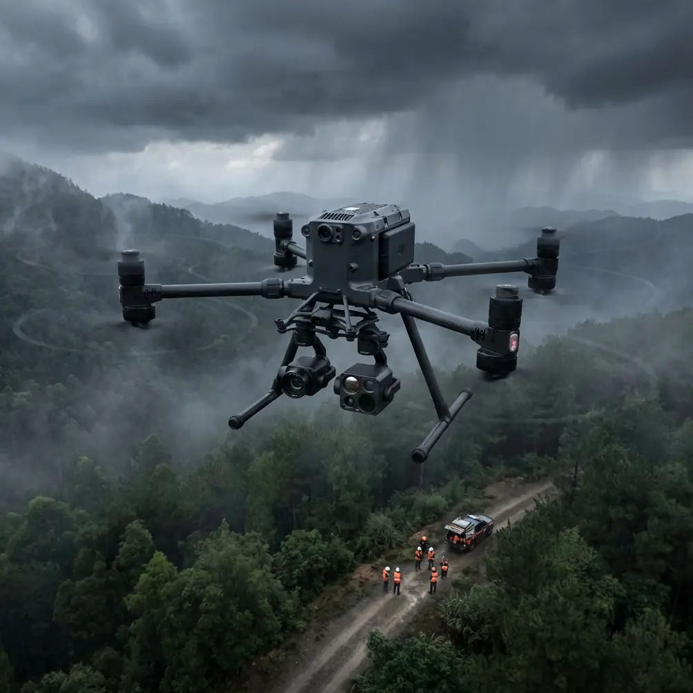
Field Report: Scouting Coastal Venues with the Matrice 400 in Shared Airspace
META: Expert field report on using the Matrice 400 for coastal venue scouting, with operational lessons on wind, shared airspace, stability, endurance planning, and safe pre-flight practice.
Coastal venue scouting looks straightforward until the site visit starts answering back.
The wind shifts across open water. Salt residue builds up where most crews forget to look. Radio conditions change as marinas, hotels, service roads, and temporary event infrastructure all compete for the same slice of airspace and spectrum. If you are evaluating a venue for staging, mapping, inspection, logistics planning, or live-event support, the aircraft matters. Just as much, the operating framework around it matters.
That is why the Matrice 400 conversation should not be limited to payloads, camera choices, or headline specs. The more useful lens is this: how does a platform like the Matrice 400 fit into the next phase of normalized drone operations in places where the sky is already busy?
At AUVSI XPONENTIAL 2026 in Detroit, officials from the FAA, test sites, industry, and government described Project ULTRA as a joint effort aimed at normalizing drone operations in shared airspace. One of the key proving grounds is the Grand Forks test environment, where scalable systems are being developed for UAS operations and logistics coordination. For anyone scouting coastal venues with a Matrice 400, that is not background noise. It is the operating future arriving early.
Why shared airspace matters more at coastal venues
Coastal venues compress complexity.
You may be working above a resort shoreline in the morning, then a marina access corridor in the afternoon, and a temporary event footprint by sunset. Helicopter activity, banner tow aircraft, sightseeing traffic, maintenance crews, and utility operations can all overlap. Even where the mission itself is simple—capture orthomosaic data for photogrammetry, verify access routes, assess drainage, inspect roofs, or establish temporary communications coverage—the airspace is rarely simple.
Project ULTRA matters because it points toward scalable systems rather than one-off approvals and isolated missions. That shift is especially relevant for Matrice 400 operators who want repeatable workflows across multiple venues. If the goal is to normalize drone activity in shared airspace, then the best operators will be the ones who already think beyond the aircraft and plan around coordination, procedural discipline, and interoperability.
In practical terms, that affects how you scout.
A venue survey is no longer just “Can I get the shots?” It becomes: Can this mission be integrated cleanly into a shared operating environment? Can the team maintain stable links, predictable flight behavior, and consistent data quality while other airspace users continue normal activity? A larger enterprise platform like the Matrice 400 belongs in that conversation because it is typically deployed for jobs where consistency, not improvisation, pays the bills.
The pre-flight step that coastal crews skip too often
Before discussing endurance, transmission, or BVLOS readiness, there is one unglamorous habit that deserves more attention: cleaning.
Specifically, a pre-flight cleaning step around the airframe’s exposed surfaces, sensor windows, landing gear interfaces, vents, payload mounts, and battery contact areas. In coastal work, salt mist and fine grit do not always look dramatic, but they quietly degrade trust in the aircraft. They can affect obstacle sensing clarity, thermal imaging surfaces, connection reliability, and mechanical fit where you least want a surprise.
I insist on a short wipe-down and visual check before first launch and again before battery changes if the site is windy. Not because it looks professional, but because safety systems only help when they can see, seat, and communicate properly.
This matters even more on a platform expected to support higher-value operations such as thermal signature analysis, wide-area mapping, or repeat flights for change detection. If your Matrice 400 is collecting photogrammetry data for a coastal venue, the mission depends on stable, repeatable capture geometry. Tiny preventable issues at takeoff often become expensive processing problems later, especially when you are tying outputs to GCP-backed survey control.
A clean aircraft is not a cosmetic preference. It is the first layer of data integrity.
Wind, range, and the coastal planning trap
Most venue scouts underestimate wind not because they ignore it, but because they simplify it.
Aerodynamic performance references make a useful point here: wind changes ground distance even when it does not change the selected airspeed or throttle setting. In other words, the aircraft may be flying the same way through the air, while the mission result on the ground shifts significantly. For coastal work, that distinction is critical.
A shoreline venue can give you smooth outbound progress with a tailwind component and then stretch your return leg into a slower, more energy-hungry recovery. That affects more than flight time. It affects whether a mapping block closes cleanly, whether a thermal pass is still within the ideal inspection window, and whether your reserve planning was based on ground assumptions instead of air assumptions.
The old performance logic still applies beautifully to modern UAV operations: air distance and ground distance are not the same thing, and the correction applies to all aircraft. Translate that into Matrice 400 field use and the lesson is blunt—do not judge mission viability only by route length on the map.
For coastal venue scouting, I plan every longer leg around the worst reasonable return condition, not the best outbound condition. That becomes even more relevant if the mission profile leans toward BVLOS-style corridor thinking, even where the operation itself remains within your approved framework. Shared-airspace normalization, the kind Project ULTRA is targeting, will reward operators who already build flights around predictable margins instead of optimistic ones.
Stability is not just an aircraft design topic
One of the more interesting design references in the source material has nothing to do with drones at first glance. It discusses static stability margins in aircraft design, including a minimum value of 0.05 and the reality that some larger aircraft designs may target values around 0.09 to 0.12 depending on broader aerodynamic factors. It also notes that if designers move toward relaxed stability, the reliability burden on the augmentation system becomes severe—failure probability must be extraordinarily low, on the order of 10^-x per flight in the cited context, which is why such approaches demand robust fly-by-wire foundations.
Why should a Matrice 400 operator care?
Because the operational meaning is bigger than the math. Stable flight is never just about raw control authority. It is about how much trust you place in the aircraft-control stack to maintain consistent behavior when conditions turn messy. Coastal operations do that to aircraft. Gusts roll off structures. Heat plumes rise from parking areas. The edge between land and water can create very different low-altitude conditions within a short distance.
For a venue scout, that means two things.
First, platform stability directly influences data quality. If you are flying photogrammetry runs, inconsistent attitude behavior can show up downstream as weaker overlap quality, harder reconstructions, and more manual cleanup. If you are conducting thermal signature work on roofs, façades, or electrical equipment, small stability issues can blur the interpretation window.
Second, system reliability should shape how ambitious you get with mission design. The more your operation depends on automated consistency—repeat lines, precise hovering, reliable transmission, smart battery rotation, coordinated multi-stop site review—the less room there is for casual maintenance and sloppy pre-flight discipline. Enterprise crews often talk about capability. The better ones talk about controllability under pressure.
That is a more useful way to think about the Matrice 400 than by treating it as a flying camera with extra endurance.
Coastal venue scouting is a logistics mission disguised as aerial work
Project ULTRA’s emphasis on scalable systems for UAS operations and logistics is a clue. The drone may be the visible tool, but the mission is often logistical at its core.
A Matrice 400 used at a coastal venue might be tasked to map ingress and egress routes, identify staging areas, inspect rooftops and seawall edges, verify line-of-sight obstructions, locate temporary generator zones, or support infrastructure checks before crews mobilize. That is not one mission. It is a stack of linked decisions, each improved by accurate aerial data gathered under repeatable conditions.
This is where operational features such as O3 transmission resilience, AES-256-secured data links, and hot-swap battery workflows become more than brochure terminology.
If you are scouting a venue with multiple structures and reflective surfaces, robust transmission matters because signal behavior can become inconsistent around concrete, steel, vessels, and shoreline clutter. If you are collecting commercially sensitive site data—utilities, access control layouts, roof conditions, back-of-house logistics—secure transmission matters because not every venue assessment is public-facing. And if the site window is narrow due to tides, wind changes, contractor access, or event setup schedules, hot-swap batteries matter because downtime between sorties can turn a clean capture session into a fragmented one.
Those details are operational, not ornamental.
If you want to compare site constraints or discuss a practical deployment plan for a waterfront job, you can message our field team here.
How I would structure a Matrice 400 coastal scouting day
A strong Matrice 400 field day at a coastal venue usually starts with restraint.
Not the big overview flight first. The small diagnostic one.
I begin with a low-risk pass to read the site: wind drift at different edges, salt exposure, bird activity, glare conditions, and actual link behavior where the map suggested no issue. This first launch is where that pre-flight cleaning step proves its worth. If sensing surfaces, payload glass, and battery interfaces are clean, you start from a known baseline.
Then I separate the mission into outputs rather than flight styles:
- one block for photogrammetry with GCP awareness and overlap discipline
- one block for thermal signature review where time-of-day and surface conditions matter
- one block for operational scouting: access roads, rooftop plant, temporary structures, shoreline protection, and crowd-flow constraints
That split prevents the common mistake of trying to get every deliverable from one compromised sortie.
If wind is building, the mapping block goes earlier. If reflective heating is affecting thermal utility, the inspection block moves. If airspace activity increases, the shorter tactical flights stay while the broader area work pauses. Shared-airspace normalization is not only a regulatory conversation. It is also a mindset: fly in a way that adapts cleanly to the environment instead of trying to overpower it.
The larger takeaway from Project ULTRA for Matrice 400 operators
The most interesting thing about Project ULTRA is not that multiple stakeholders are involved, though they are. It is that the project is being built in a real test environment—Grand Forks—to develop scalable systems for actual UAS and logistics operations. That gives the effort practical weight.
For Matrice 400 operators, especially those supporting commercial site scouting in coastal areas, the message is clear. The market is moving toward normal operations in mixed-use airspace, not isolated exceptions. The crews who thrive will be the ones who can combine aircraft capability with disciplined procedures, clean data capture, secure communications, and realistic endurance planning.
That is exactly why a coastal venue scout is a useful test case. It forces the aircraft, the pilot, and the workflow to answer real questions all at once:
Can the platform maintain stable behavior in difficult microclimates? Can the operator account for wind’s effect on ground progress rather than just airspeed? Can the crew protect sensor performance with simple maintenance steps before those steps become critical? Can the mission fit into a future where drones are expected to operate routinely, not experimentally, alongside other airspace users?
The Matrice 400 earns its place when the answer to all four is yes.
And that answer is rarely created by a spec sheet. It is created in the field—on windy edges, tight schedules, mixed airspace, and jobs where a clean second flight matters more than a flashy first one.
Ready for your own Matrice 400? Contact our team for expert consultation.