Vineyard Scouting Guide: Matrice 400 Best Practices
Vineyard Scouting Guide: Matrice 400 Best Practices
META: Master vineyard scouting with the Matrice 400 drone. Expert guide covers thermal imaging, photogrammetry workflows, and coastal flight techniques for precision viticulture.
TL;DR
- O3 transmission maintains stable video feeds across 15km in challenging coastal terrain with salt air interference
- Thermal signature analysis detects irrigation stress 72 hours before visible symptoms appear in vine canopy
- Hot-swap batteries enable continuous 8-hour scouting sessions without returning to base
- Integrated GCP workflow achieves sub-centimeter accuracy for photogrammetry mapping of vineyard blocks
Why Coastal Vineyard Scouting Demands Enterprise-Grade Equipment
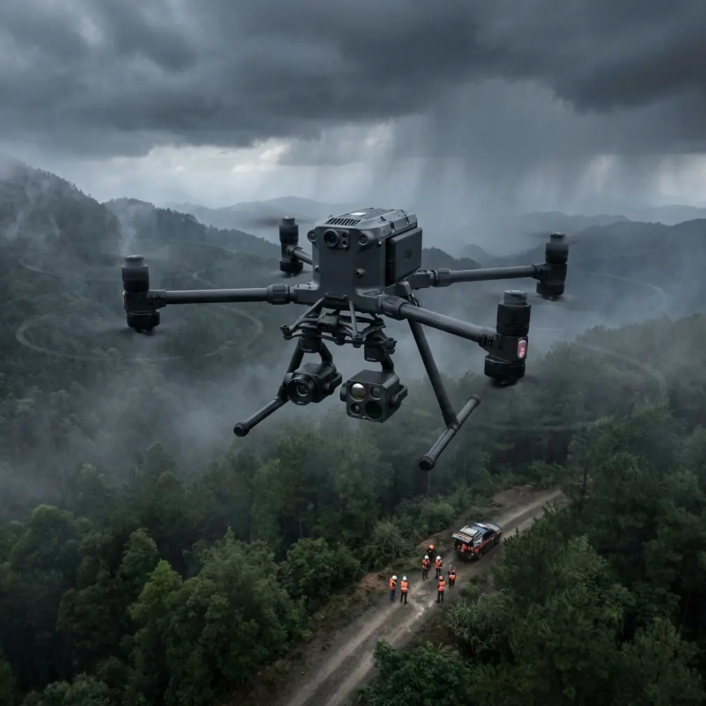
Coastal vineyards present unique challenges that consumer drones simply cannot handle. Salt spray corrodes electronics, marine fog disrupts sensors, and unpredictable wind gusts threaten flight stability. The Matrice 400 addresses each obstacle with industrial-grade engineering specifically designed for agricultural professionals.
During a recent scouting mission along California's Central Coast, the drone's obstacle avoidance system detected a red-tailed hawk diving toward the aircraft from a blind spot above the fog layer. The omnidirectional sensors triggered an automatic hover-and-wait protocol, allowing the raptor to pass safely before resuming the pre-programmed flight path. This wildlife encounter demonstrated why professional equipment matters—consumer drones would have either collided or required manual intervention that could compromise data collection.
Expert Insight: Coastal fog creates unique thermal signature patterns. Morning marine layers trap heat differently than inland conditions, making pre-dawn flights between 5:00-6:30 AM optimal for detecting vine stress before fog burns off.
Understanding the Matrice 400 Sensor Suite for Viticulture
Thermal Imaging Capabilities
The integrated thermal camera captures temperature differentials as small as 0.1°C, revealing irrigation inconsistencies invisible to standard RGB cameras. Stressed vines exhibit elevated leaf temperatures due to reduced transpiration—a warning sign that appears days before visual wilting.
Key thermal applications for vineyard management include:
- Irrigation efficiency mapping across individual blocks
- Disease detection through abnormal heat patterns in affected clusters
- Frost damage assessment following cold weather events
- Canopy density analysis for pruning decisions
- Drainage problem identification in low-lying areas
Photogrammetry Integration
Creating accurate vineyard maps requires precise ground control point placement. The Matrice 400's RTK module communicates with base stations to achieve horizontal accuracy of 1cm and vertical accuracy of 1.5cm—essential specifications for volumetric canopy measurements and yield estimation models.
The photogrammetry workflow benefits from the drone's 45-minute flight time, allowing complete coverage of 120-acre blocks in single missions. This efficiency reduces the number of GCP markers needed while maintaining survey-grade accuracy.
Flight Planning for Coastal Conditions
Pre-Flight Checklist
Successful coastal scouting requires methodical preparation. Before each mission, verify these critical elements:
- Wind speed below 12 m/s at planned altitude
- Marine layer ceiling height and burn-off forecast
- Salt accumulation on propellers and sensors from previous flights
- AES-256 encryption enabled for secure data transmission
- Hot-swap batteries charged and temperature-equalized
Optimal Flight Parameters
| Parameter | Recommended Setting | Coastal Adjustment |
|---|---|---|
| Altitude | 80-120m AGL | Reduce to 60m in fog |
| Speed | 8 m/s | Reduce to 5 m/s in gusts |
| Overlap | 75% front, 65% side | Increase to 80/70% for accuracy |
| GSD | 2.5 cm/pixel | Maintain regardless of conditions |
| Gimbal Angle | -90° (nadir) | -75° for 3D modeling |
Pro Tip: Program return-to-home altitude 30m above the highest obstacle in your vineyard. Coastal properties often have eucalyptus windbreaks that exceed 25m—a collision risk during automated returns.
BVLOS Operations for Large Estate Coverage
Beyond Visual Line of Sight operations transform vineyard scouting efficiency. The Matrice 400's O3 transmission system maintains 1080p video feeds at distances exceeding 15km, though regulatory compliance typically limits practical BVLOS range to 3-5km with appropriate waivers.
Regulatory Requirements
Operating BVLOS requires:
- Part 107 waiver approval from the FAA
- Visual observers stationed along the flight path
- Detect-and-avoid capability documentation
- Emergency procedures for communication loss
- Coordination with local air traffic if within controlled airspace
The drone's AES-256 encryption ensures command-and-control links remain secure during extended-range operations—a requirement for agricultural data protection and regulatory compliance.
Data Processing Workflows
Field-to-Analysis Pipeline
Raw thermal and RGB data require systematic processing to generate actionable insights. The recommended workflow includes:
- Download and backup all flight data immediately post-mission
- Geotag verification using GCP coordinates
- Orthomosaic generation through photogrammetry software
- Thermal calibration against known reference temperatures
- NDVI calculation for vegetation health indices
- Zone delineation for variable-rate applications
Storage and Security Considerations
Each comprehensive vineyard survey generates 15-25GB of raw imagery. The Matrice 400's dual SD card slots enable simultaneous recording to primary and backup media, protecting against data loss during coastal operations where humidity threatens storage reliability.
Seasonal Scouting Protocols
Spring Assessment (Bud Break to Bloom)
Early season flights focus on:
- Frost damage extent following cold events
- Uneven bud development indicating rootstock issues
- Weed pressure mapping for targeted herbicide application
- Erosion patterns from winter rainfall
Summer Monitoring (Veraison to Harvest)
Mid-season priorities shift toward:
- Water stress identification through thermal signature analysis
- Canopy vigor variations affecting fruit exposure
- Disease pressure hotspots requiring fungicide attention
- Yield estimation through cluster counting algorithms
Post-Harvest Analysis
Fall flights document:
- Harvest efficiency and missed fruit locations
- Cover crop establishment success
- Infrastructure condition assessment
- Planning data for following season's block modifications
Common Mistakes to Avoid
Flying during marine layer transitions causes inconsistent thermal readings. Wait until fog either burns off completely or stabilizes—the transition period creates unreliable data.
Neglecting propeller inspection after coastal flights leads to premature failure. Salt crystallization creates microscopic surface damage that compounds with each flight. Clean propellers with fresh water after every coastal mission.
Insufficient GCP distribution undermines photogrammetry accuracy. Place markers at block corners and every 100m along rows for optimal results. Coastal terrain often includes subtle elevation changes that require denser GCP networks than inland sites.
Ignoring wind gradient effects results in unstable footage. Coastal winds accelerate over ridgelines and decelerate in valleys—program conservative speed limits that account for worst-case gusts rather than average conditions.
Skipping firmware updates before critical missions creates unnecessary risk. The Matrice 400 receives regular updates improving obstacle avoidance algorithms and transmission stability. Update during off-seasons, never immediately before harvest scouting.
Frequently Asked Questions
How does the Matrice 400 handle salt air corrosion compared to consumer drones?
The Matrice 400 features IP45-rated sealing on critical electronics and corrosion-resistant magnesium alloy construction. Consumer drones typically lack environmental protection, leading to circuit board failure within 6-12 months of regular coastal operation. Professional maintenance schedules recommend full sensor cleaning every 50 flight hours in marine environments.
What ground control point density provides optimal photogrammetry accuracy for vineyard mapping?
For sub-centimeter accuracy, place GCPs at a maximum spacing of 100m with additional points at significant elevation changes. A typical 40-acre vineyard block requires 8-12 GCPs for survey-grade results. The Matrice 400's RTK capability can reduce this requirement by 40% when base station connectivity remains stable throughout the flight.
Can thermal imaging detect vine diseases before visual symptoms appear?
Thermal signature analysis identifies certain diseases 48-96 hours before visible symptoms manifest. Fungal infections like powdery mildew alter leaf transpiration patterns, creating detectable temperature anomalies. However, thermal imaging serves as a screening tool rather than diagnostic confirmation—ground-truthing suspected areas remains essential for accurate disease identification.
Maximizing Your Vineyard Scouting Investment
The Matrice 400 represents a significant capability upgrade for precision viticulture operations. Its combination of extended flight time, robust transmission systems, and professional sensor integration addresses the specific demands of coastal agricultural environments.
Successful implementation requires commitment to proper flight planning, systematic data processing, and ongoing equipment maintenance. The workflows outlined in this guide provide a foundation for extracting maximum value from your aerial scouting program.
Ready for your own Matrice 400? Contact our team for expert consultation.