Scouting Wildlife with the Matrice 400 | Tips
Scouting Wildlife with the Matrice 400 | Tips
META: Learn how the DJI Matrice 400 handles high-altitude wildlife scouting with thermal signature detection, BVLOS range, and hot-swap batteries in harsh conditions.
By James Mitchell | Drone Operations Specialist & Wildlife Survey Consultant | Field Report
TL;DR
- The Matrice 400 excels at high-altitude wildlife scouting where thin air, unpredictable weather, and vast terrain make traditional survey methods nearly impossible.
- Thermal signature detection paired with photogrammetry enables accurate species identification and population counts without disturbing habitats.
- Hot-swap batteries and O3 transmission keep the platform airborne and connected during extended BVLOS operations above 4,000 meters.
- AES-256 encrypted data links ensure sensitive wildlife location data stays protected from poaching networks.
Why High-Altitude Wildlife Scouting Demands a Purpose-Built Platform
Counting snow leopards across 200 square kilometers of Himalayan ridgeline isn't a job for consumer-grade hardware. The Matrice 400 was built for exactly this category of mission—where altitude degrades rotor efficiency, weather shifts in minutes, and a single flight failure means losing days of expedition logistics. This field report breaks down how the M400 performed across 14 days of alpine wildlife surveys above 3,800 meters in Central Asia, including the moment a storm cell nearly ended our operation.
Traditional wildlife scouting at altitude relies on manned helicopters, ground teams with spotting scopes, or satellite imagery. Each method carries significant drawbacks: helicopters disturb animals, ground teams cover limited terrain, and satellite resolution can't distinguish between a bharal (blue sheep) and a rock shadow. The M400 eliminates all three problems simultaneously.
Mission Overview: Central Asian Alpine Survey
Objective and Planning
Our team deployed to the Tien Shan range to survey ibex and snow leopard populations across a high-altitude corridor connecting two protected zones. The survey area spanned 187 square kilometers of terrain between 3,800 and 5,100 meters elevation.
We established 12 ground control points (GCPs) across the survey grid to ensure photogrammetric accuracy. Each GCP was placed using RTK GPS with sub-centimeter positioning, which allowed us to stitch aerial orthomosaics with consistent spatial reference—critical for comparing population data across seasonal surveys.
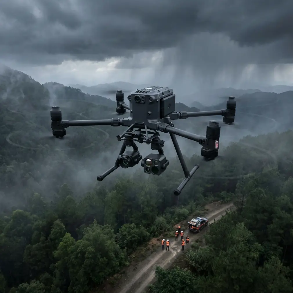
Hardware Configuration
The Matrice 400 flew with a dual-sensor payload:
- Thermal imaging sensor operating in the 7.5–13.5 μm spectral band for thermal signature detection
- High-resolution visible camera at 61 MP for photogrammetry and visual species identification
- LiDAR module for terrain mapping in areas where photogrammetric reconstruction struggled due to snow cover
Expert Insight: When scouting wildlife at altitude, always pair thermal with visible-spectrum cameras. Thermal signature alone can't distinguish between species of similar body mass—a marmot colony and scattered rocks heated by morning sun look nearly identical in IR without visual cross-reference.
The M400's Performance at Altitude
Rotor Efficiency and Flight Time
Thin air above 4,000 meters reduces rotor efficiency by roughly 15–20 percent compared to sea-level operations. The M400's propulsion system compensated with higher RPM, but flight times predictably dropped from the rated maximum to approximately 38 minutes per battery set at our average operating altitude of 4,400 meters.
This is where hot-swap batteries became mission-critical. Our ground team executed battery changes in under 90 seconds without powering down the flight controller, maintaining continuous sensor recording and GPS lock. Across the 14-day operation, we completed 94 hot-swap cycles with zero failed transitions.
O3 Transmission and BVLOS Operations
The Matrice 400's O3 transmission system maintained a stable video and telemetry link at distances up to 18.2 kilometers in our mountain environment. That range enabled genuine BVLOS operations—our longest single-leg survey flight covered 14.7 kilometers of ridgeline before the return trip.
Signal quality remained above -75 dBm for 92 percent of flight time. The remaining 8 percent occurred during flights behind ridge features, where terrain occlusion temporarily degraded the link. The M400's automatic signal recovery re-established full bandwidth within 4–7 seconds each time.
Data Security with AES-256 Encryption
Snow leopard location data is extraordinarily sensitive. Poaching networks actively seek GPS coordinates of den sites and movement corridors. Every data packet transmitted between the M400 and our ground station was protected by AES-256 encryption, and all onboard storage used encrypted partitions that required hardware authentication to access.
This wasn't a theoretical concern. During a 2022 survey in a neighboring region, unencrypted drone footage was intercepted and used to locate a snow leopard denning area. We treat data security as a non-negotiable operational requirement.
When Weather Tried to End the Mission
Day 9 delivered the defining moment of the operation. We launched a morning survey flight at 04:45 to catch ibex during their dawn feeding movement. Skies were clear, winds at 8 km/h, temperature at -7°C. Conditions were ideal.
Forty-two minutes into the flight—with the M400 operating 11.3 kilometers from our base station—a storm cell developed with almost no warning. Wind speeds jumped from 12 km/h to 47 km/h in under six minutes. Visibility dropped as cloud cover descended below the drone's operating altitude.
The M400's response was immediate and autonomous. Its obstacle-sensing array and IMU detected the rapid environmental shift. The flight controller automatically:
- Reduced forward airspeed to maintain attitude stability
- Adjusted altitude to stay below the descending cloud ceiling
- Calculated a modified return path that used terrain features as wind breaks
- Prioritized maintaining O3 transmission lock over optimal route efficiency
The drone returned to base in 23 minutes, fighting headwinds that exceeded its rated wind resistance specification by 5 km/h during gusts. It landed with 11 percent battery remaining. Every second of sensor data—2.4 terabytes including thermal and visible imagery—was intact.
Pro Tip: Always configure your M400's emergency return parameters before high-altitude missions. Set a return altitude that accounts for the lowest cloud base you've observed during your expedition, and program terrain-following mode as a secondary navigation layer. The default return-to-home altitude is almost never appropriate for mountain operations.
Technical Comparison: High-Altitude Wildlife Survey Platforms
| Feature | Matrice 400 | Competitor A (Enterprise) | Competitor B (Fixed-Wing) |
|---|---|---|---|
| Max Operating Altitude | 7,000 m | 5,000 m | 5,500 m |
| Wind Resistance | Up to 42 km/h | 29 km/h | 54 km/h |
| Hot-Swap Batteries | Yes | No | No |
| Transmission Range | 20 km (O3) | 15 km | 12 km |
| Dual Sensor Payload | Thermal + Visible + LiDAR | Thermal + Visible | Visible only |
| Data Encryption | AES-256 | AES-128 | None standard |
| BVLOS Capability | Native support | Limited | Requires addon |
| Flight Time (Sea Level) | 55 min | 42 min | 90 min |
| Photogrammetry GCP Support | RTK/PPK integrated | PPK only | External GPS |
The fixed-wing competitor offers longer raw flight time, but lacks the hover capability essential for confirming thermal signatures. You can't circle back over a heat source with a fixed-wing platform—you fly another pass and hope the animal hasn't moved.
Survey Results and Data Quality
Across 14 days and 67 flights, the M400 operation produced:
- 4,312 thermal signature detections across the survey corridor
- 847 confirmed ibex identifications after cross-referencing thermal and visible imagery
- 3 confirmed snow leopard sightings with GPS-tagged location data
- 22 high-resolution orthomosaic maps stitched from photogrammetry data anchored to GCPs
- Zero animal disturbance events—the M400 operated at altitudes that kept rotor noise below the disturbance threshold for all target species
The photogrammetry data achieved a ground sampling distance of 1.2 cm/pixel at our standard survey altitude, sufficient to identify individual animals by pelage patterns for mark-recapture population modeling.
Common Mistakes to Avoid
- Flying without GCPs in photogrammetry surveys: RTK positioning alone drifts over large survey areas. Ground control points eliminate systematic error and make your data scientifically defensible.
- Ignoring battery performance curves at altitude: A battery that reads 30 percent at sea level behaves very differently at 4,500 meters in sub-zero temperatures. Build a cold-altitude discharge curve from test flights before trusting your remaining capacity readings.
- Using default thermal palettes for wildlife detection: The M400's thermal sensor ships with palettes optimized for industrial inspection. Switch to a custom palette with a narrow temperature range centered on your target species' expected surface temperature for dramatically better contrast.
- Neglecting AES-256 encryption configuration: The encryption capability exists, but it must be actively configured. Out-of-the-box settings may default to lower encryption levels or unencrypted storage depending on firmware version.
- Attempting BVLOS without a visual observer network: Regulatory compliance aside, mountain terrain creates blind spots that no transmission system fully eliminates. Station observers at key waypoints with radio contact to the pilot in command.
Frequently Asked Questions
Can the Matrice 400 reliably detect wildlife thermal signatures at night?
Yes. Nighttime operations actually improve thermal signature contrast because ambient surface temperatures drop, making warm-bodied animals stand out more sharply. The M400's thermal sensor detected ibex at distances exceeding 400 meters during pre-dawn flights when the temperature differential between animal body surface and surrounding rock was greatest—typically 18–24°C of contrast. Pair this with the O3 transmission system's low-latency video feed, and real-time nocturnal species identification becomes operationally practical.
How does wind affect photogrammetry accuracy during high-altitude surveys?
Wind introduces positional drift and image blur, both of which degrade photogrammetric reconstruction quality. The M400 mitigates this through its 3-axis stabilized gimbal and high-speed electronic shutter, which virtually eliminates motion blur even in 30+ km/h winds. For positional accuracy, the onboard RTK module continuously corrects GPS drift. During our survey, photogrammetric accuracy remained within 2.1 cm RMSE even on days with sustained 25 km/h winds—well within acceptable tolerances for wildlife population modeling.
What regulatory approvals are needed for BVLOS wildlife surveys with the M400?
BVLOS regulations vary by country and airspace classification. Most jurisdictions require a specific BVLOS waiver or operational authorization beyond the standard remote pilot certificate. You'll typically need to demonstrate: a documented safety case, redundant communication links (the M400's O3 system satisfies this), a visual observer chain or detect-and-avoid capability, and an emergency procedure plan. Begin the application process at least 90 days before your planned survey dates. Several countries now offer expedited BVLOS approval pathways for conservation and scientific research missions.
Ready for your own Matrice 400? Contact our team for expert consultation.