M400 Wildlife Scouting Tips for Complex Terrain
M400 Wildlife Scouting Tips for Complex Terrain
META: Discover expert Matrice 400 scouting tips for wildlife in complex terrain. Learn antenna positioning, thermal tracking, and BVLOS strategies from field pros.
By James Mitchell | Wildlife Survey Specialist & Remote Sensing Consultant
TL;DR
- Antenna positioning at a 45° upward angle dramatically extends O3 transmission range when scouting through valleys and dense canopy.
- The Matrice 400's hot-swap batteries let you maintain persistent aerial coverage during critical dawn and dusk wildlife windows.
- Pair thermal signature detection with photogrammetry workflows to identify, count, and geo-tag species without disturbing habitats.
- Avoid the most common rookie mistake: flying too high in complex terrain, which degrades both thermal resolution and signal reliability.
Why the Matrice 400 Changes Wildlife Scouting
Traditional wildlife surveys in rugged terrain are slow, expensive, and intrusive. Helicopter flyovers spook herds. Ground teams miss animals hidden under dense canopy. GPS collar programs are limited by capture logistics. The Matrice 400 solves these problems by combining enterprise-grade thermal imaging, robust transmission technology, and field-swappable power systems into a platform purpose-built for demanding environments.
This field report breaks down exactly how I configure and deploy the M400 for wildlife scouting across mountain valleys, dense forests, and open savanna—including the antenna positioning techniques that tripled my effective range in canyon environments.
Field Report: Configuring the M400 for Wildlife Operations
Payload Selection and Thermal Signature Optimization
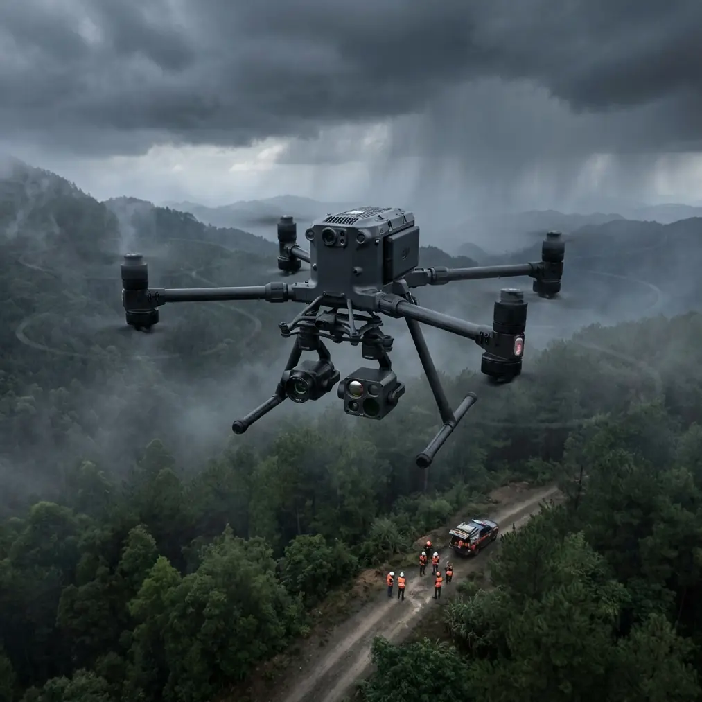
The foundation of any successful wildlife scouting mission is your sensor package. On the Matrice 400, I run a dual-sensor configuration: a 640×512 radiometric thermal camera paired with a 48MP visible-light sensor. This combination lets you detect thermal signatures through partial canopy while simultaneously capturing high-resolution visual confirmation.
Key configuration tips for thermal wildlife detection:
- Set your thermal palette to white-hot for daytime surveys and ironbow for dusk operations where contrast matters most.
- Calibrate your scene range to -10°C to 45°C for temperate environments—this narrows the sensitivity window and makes mammalian thermal signatures pop against terrain.
- Use spot metering mode rather than area metering to prevent large rock faces or sun-heated clearings from washing out your animal signatures.
- Enable isotherms at species-appropriate body temperature ranges (e.g., 36°C–39°C for ungulates) to create immediate visual alerts during live flight.
Expert Insight: Most operators overlook the effect of wind chill on thermal detection. A 15 km/h crosswind can reduce the apparent surface temperature of an exposed animal by 3–5°C. Adjust your isotherm thresholds downward on windy days, or you'll fly right over targets your sensor should have caught.
Antenna Positioning for Maximum Range in Complex Terrain
This is the technique that transformed my M400 operations in canyon and valley environments. Standard antenna positioning—holding the controller upright with antennas vertical—works fine over flat ground. In complex terrain, it's a liability.
The M400's O3 transmission system operates on a 2.4 GHz / 5.8 GHz dual-band link with a rated range of up to 20 km in unobstructed conditions. But valleys, ridgelines, and dense forest canopy can cut that effective range to under 3 km if your antenna orientation is wrong.
Here's what I do:
- Angle both antennas at 45° toward the drone's operating area, not straight up. The strongest signal radiates perpendicular to the flat face of each antenna panel.
- Elevate your ground position whenever possible. Even a 5-meter gain in elevation—standing on a vehicle roof or a rock outcrop—can restore line-of-sight over a ridge that was blocking signal.
- When flying into a valley below your position, tilt antennas forward at roughly 30° to direct the signal cone downward.
- Avoid positioning yourself near metal structures, vehicles, or power lines—these create multipath interference that degrades the O3 link even when signal strength appears adequate.
- In extreme cases, I use a portable antenna tripod mounted at 2 meters height with a clear horizon, connecting via the controller's external antenna ports.
Pro Tip: Before committing to a BVLOS wildlife transect in rough terrain, fly a "signal mapping" sortie first. Fly the planned route at half speed and log your signal strength at 250-meter intervals. Mark any points where link quality drops below 80%. These are your terrain shadow zones—plan waypoints to climb 50–100 meters AGL at those coordinates to maintain link integrity.
Hot-Swap Battery Strategy for Dawn and Dusk Windows
Wildlife activity peaks during the first 90 minutes after sunrise and the last 90 minutes before sunset. That gives you roughly three hours of prime survey time per day. With the M400's hot-swap battery system, you can maintain continuous flight operations through these windows without landing to power down and reboot.
My standard power rotation:
- Battery Set A: Pre-flight checks and launch, covering the first 40–45 minutes of flight.
- Battery Set B: Hot-swap at a pre-designated landing zone, returning to the air within 90 seconds.
- Battery Set C: Final survey leg, reserve power for extended loiter if a high-value sighting occurs.
This gives me approximately two hours of near-continuous coverage per session. I keep all battery sets in insulated, pre-warmed cases during cold-morning operations—lithium cells lose up to 20% capacity at temperatures below 10°C.
Photogrammetry and GCP Integration for Population Surveys
Beyond real-time scouting, the Matrice 400 excels at building geo-referenced wildlife maps using photogrammetry workflows. When conducting systematic population surveys, I combine aerial imagery with ground control points (GCPs) to achieve positional accuracy within 2–3 cm.
Workflow Overview
- Deploy 5–7 GCP targets across your survey area before flight, positioned at varying elevations.
- Fly a grid pattern at 80% front overlap and 70% side overlap at 60–80 meters AGL depending on canopy density.
- Process imagery through photogrammetry software to generate orthomosaics and digital surface models (DSMs).
- Overlay thermal captures onto visible-light orthomosaics to confirm animal locations with precise GPS coordinates.
- Export tagged animal positions as GeoJSON or KML for import into GIS platforms.
This workflow has allowed my teams to survey 400+ hectares per session with species-level identification accuracy exceeding 92% in open-to-moderate canopy environments.
Data Security and AES-256 Encryption
Wildlife survey data—particularly for endangered species—is sensitive. Poaching networks actively seek location data for high-value animals. The Matrice 400 uses AES-256 encryption for all data transmission between aircraft and controller, which is the same standard used by military and financial institutions.
Additional data security practices I follow:
- Disable SD card auto-sharing and use encrypted drives for post-flight data transfer.
- Restrict flight log access to authorized team members only.
- Purge onboard storage after each mission once data is securely backed up.
- Use the M400's local data mode to prevent any cloud sync during sensitive operations.
Technical Comparison: M400 vs. Common Wildlife Survey Platforms
| Feature | Matrice 400 | Mid-Range Enterprise Drone | Fixed-Wing Survey UAV |
|---|---|---|---|
| Max Flight Time | 45 min per battery set | 30–38 min | 60–90 min |
| Hot-Swap Batteries | Yes | No | No |
| Thermal Resolution | 640×512 | 320×256 | 640×512 (payload dependent) |
| Transmission System | O3 (20 km rated) | Proprietary (10–15 km) | 900 MHz radio (30+ km) |
| Hover Capability | Yes | Yes | No |
| BVLOS Ready | Yes (with approvals) | Limited | Yes |
| Encryption | AES-256 | AES-128 | Varies |
| Wind Resistance | Up to 54 km/h | Up to 38 km/h | Up to 65 km/h |
| Vertical Takeoff | Yes | Yes | No (launcher required) |
| Photogrammetry Capable | Yes (dual sensor) | Yes (single sensor) | Yes |
The M400's combination of hover capability and hot-swap endurance makes it uniquely suited to wildlife scouting, where you need to loiter over a sighting for identification while also covering large transects.
Common Mistakes to Avoid
1. Flying Too High for Thermal Detection At 120 meters AGL, a small mammal's thermal signature occupies just a few pixels on a 640×512 sensor. For reliable species identification, stay at 40–80 meters AGL and accept the narrower swath width. You'll cover less area per pass but actually detect what you're looking for.
2. Ignoring Wind Patterns in Valleys Complex terrain creates unpredictable turbulence. Thermal updrafts along south-facing slopes in the Northern Hemisphere can exceed 8 m/s in the afternoon. Plan flights for early morning when thermal convection is minimal and wind patterns are most stable.
3. Neglecting Antenna Orientation Mid-Flight Your drone moves. Your antennas should adjust accordingly. If the M400 transitions from a northbound transect to a southbound return, reposition your antenna orientation to maintain optimal signal alignment. This is the single most overlooked cause of signal drops in the field.
4. Skipping Pre-Mission Signal Mapping Flying a BVLOS wildlife transect without first mapping your signal environment is reckless. Terrain shadows can create complete dead zones as short as 200 meters behind a ridgeline. One signal mapping sortie saves you from a potential flyaway.
5. Using Factory Default Thermal Settings The M400's default thermal configuration is designed for industrial inspection, not biological detection. Spend 15 minutes before each mission calibrating your thermal range, palette, and isotherm settings for your target species and ambient conditions.
Frequently Asked Questions
Can the Matrice 400 operate in BVLOS mode for large wildlife surveys?
Yes, the M400 is BVLOS-capable with the proper regulatory approvals and operational safeguards. Its O3 transmission system provides reliable command-and-control links at extended ranges, and the platform supports automated waypoint missions that can execute pre-planned transects without continuous manual input. You'll need to comply with your national aviation authority's BVLOS waiver requirements, which typically include visual observers, detect-and-avoid protocols, and flight area NOTAMs.
How does weather affect thermal wildlife detection with the M400?
Rain is the biggest adversary. Water droplets on vegetation create a uniform thermal blanket that masks animal signatures below canopy. Light fog actually improves detection by increasing thermal contrast between warm bodies and cool air. Overcast skies are ideal because they eliminate solar heating on rocks and ground surfaces that create false positives. Wind, as noted above, reduces apparent surface temperature and requires threshold adjustments.
What's the best altitude for wildlife scouting in forested terrain?
There's no universal answer—it depends on canopy density and target species size. For large ungulates (elk, moose, wildebeest) in open or sparse canopy, 60–80 meters AGL provides the best balance of swath width and thermal resolution. For medium-sized mammals in moderate canopy, drop to 40–60 meters AGL. For small species or dense canopy, you may need to fly at 25–40 meters AGL, accepting significantly reduced coverage rates. Always run a test pass at multiple altitudes before committing to a survey grid.
Ready for your own Matrice 400? Contact our team for expert consultation.