Matrice 400 in Mountain Field Spraying: What Actually
Matrice 400 in Mountain Field Spraying: What Actually Matters When Terrain, Battery Cycles, and Signal Stability Start Working Against You
META: A field-focused Matrice 400 article for mountain spraying operations, covering battery management, transmission reliability, thermal awareness, mapping workflow, and why manual control still matters in complex terrain.
Mountain spraying looks straightforward on a planning screen. Draw the boundary. Set the height. Launch. Let the aircraft work.
Then the hillside reminds you that software does not flatten terrain, wind does not behave politely in terraces, and battery estimates that seemed comfortable at takeoff can become very uncomfortable halfway through a climb.
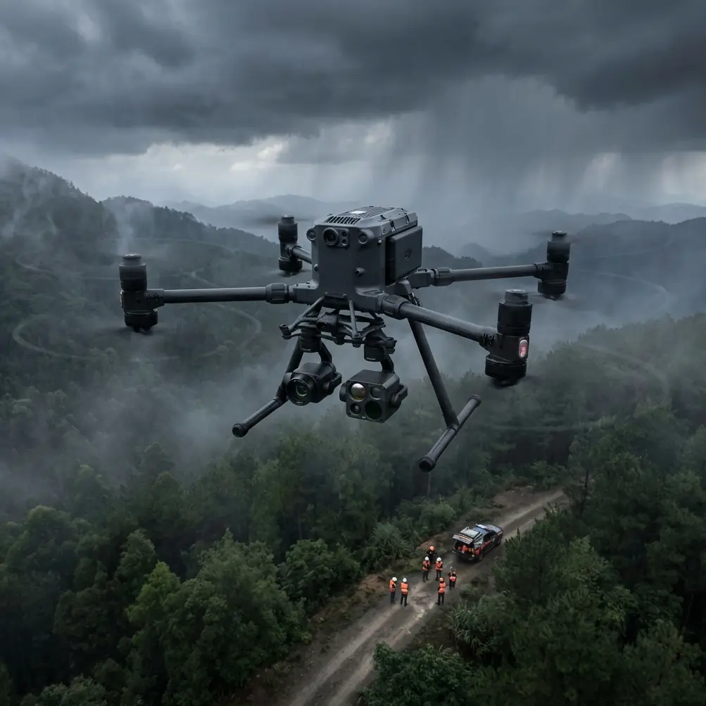
That is the right context for thinking about Matrice 400.
Not as a brochure object. Not as a vague “advanced drone platform.” But as a working aircraft that has to earn trust in broken topography where orchards, tea slopes, stepped vegetable plots, and narrow access roads turn every sortie into a small operational decision tree.
I’m writing this from the perspective of someone who prefers practical control over mythology. One recent reference outside the drone world made that point unexpectedly well: a May 1, 2026 article about Huawei’s phone “pro mode” argued that serious image results come from adjustment, not just pressing the shutter. The author described how intimidating parameters like ISO, shutter speed, EV, and white balance felt at first, even with more than a decade of photography experience, and only after a year of use did those controls become seven usable takeaways rather than a wall of complexity.
That logic applies directly to Matrice 400 operations in mountain spraying.
The operators who get consistently clean, safe, efficient field performance are rarely the ones chasing “one-tap automation.” They are the ones who understand the controls well enough to override assumptions. In mountain agriculture, that difference is not academic. It affects droplet placement, turnaround time, battery reserve, and whether the aircraft comes home with margin or with excuses.
The real problem in mountain spraying is not spraying
It is energy management under elevation change.
On flat land, battery planning is often reduced to acreage and payload. In mountain environments, that shortcut breaks down. Climbing to a terrace line, correcting lateral drift across contour winds, making repeated turns near tree rows, and negotiating irregular parcel shapes all add up. A route that looks modest in map view can consume far more power than an equivalent area in a plain.
This is where Matrice 400 discussions need more honesty. The aircraft may bring robust platform capabilities, but no aircraft escapes the arithmetic of terrain. If your field team treats battery percentage as a static comfort indicator instead of a dynamic mission variable, mountain spraying will expose the mistake quickly.
My field tip is simple: in mountain work, do not rotate batteries by percentage alone. Rotate by thermal condition, recharge timing, and climb profile history.
That sounds minor until you’ve watched two packs with similar remaining cycle counts behave very differently after successive uphill spraying runs in warm daylight. A battery that has just completed a strenuous contour mission may show an acceptable state of charge after swap logistics are sorted out, yet still be the wrong choice for the next launch if its temperature profile and recent discharge pattern suggest reduced margin under another heavy ascent.
Hot-swap capability is valuable here, not because it makes missions feel seamless, but because it gives the crew a chance to make smarter decisions without shutting the whole workflow down for too long. The best teams use that pause to inspect more than numbers on a display. They check pack temperature, mission segment complexity, ambient conditions, and whether the next leg begins with a climb, a lateral traverse, or a descent-heavy pass. In mountain agriculture, sequence matters.
A practical rule I like: assign the freshest thermal state to the sortie with the steepest first third. That is usually where bad battery judgment becomes expensive.
Terrain breaks the illusion of simple autonomy
Many buyers approach large-platform agriculture or utility aircraft with the same mindset first-time photographers bring to a camera’s pro mode: too many settings must mean the manufacturer overcomplicated something that should be easy.
The Huawei reference is useful here for one reason. The author admitted that ISO, shutter speed, EV, and white balance initially looked like needless friction. After a year, those controls became the difference between random results and repeatable ones.
Matrice 400 is similar in the only way that matters: control depth is not there to impress anyone. It exists because real conditions are messy.
For mountain spraying, that means terrain-following logic must be treated as a tool, not a guarantee. A slope with mixed canopy height, stone retaining edges, isolated utility lines, and changing vegetation density can trick mission assumptions in subtle ways. If the platform also supports photogrammetry-based planning, use it. A current terrain model is not paperwork. It is one of the few ways to reduce surprises before rotors ever spin.
This is where GCP discipline can quietly improve agricultural outcomes, even when the project is not marketed as a mapping job. Ground control points help anchor model accuracy. Better elevation understanding means better route planning and more predictable altitude behavior over uneven parcels. In mountain spraying, altitude inconsistency is not just a navigation flaw. It changes coverage quality.
Too high, and drift and dilution increase. Too low, and you create unnecessary risk near crop structure, support poles, or local terrain protrusions. When operators say a drone “didn’t spray evenly,” the root cause is often not the spray system alone. It is terrain interpretation.
O3 transmission matters more in mountains than most teams admit
Signal reliability becomes a business issue once ridgelines, orchard walls, and fragmented line-of-sight enter the picture.
This is where O3 transmission belongs in the conversation, not as a specification checkbox but as a mitigation layer. Mountain plots often create interrupted visibility, and those interruptions do not always happen where the mission planner expected. A stable transmission system gives the pilot and visual support crew more room to manage edge cases before they become retrieval problems.
That matters even more if your operation is preparing for BVLOS-aligned workflows in regions where regulation, risk assessment, and operational approvals make that relevant. I am not suggesting anyone shortcut local rules. Quite the opposite. A mountain spraying team should be conservative. But when evaluating aircraft for futureproof civilian operations, transmission integrity and link resilience are foundational, not optional.
A strong link also supports better decision-making in moment-to-moment field adjustments. On a mountain site, the pilot may need to pause, re-evaluate a boundary, skip an obstructed strip, or modify a pass sequence because wind is wrapping around a slope differently than forecast. Clean situational awareness depends on the quality of the connection back to the operator.
Thermal signature is not only for inspections
People often associate thermal signature with industrial inspection, solar farms, or roof diagnostics. In agriculture, especially mountain agriculture, it can also sharpen operational judgment.
No, thermal does not replace agronomy. It does not magically tell you everything about crop health. But on challenging slopes, temperature variation can help crews spot water stress patterns, drainage inconsistency, and localized plant stress that may justify different spray attention or a separate scouting mission before treatment.
Operationally, this matters because mountain fields are rarely uniform. Sun exposure differs by aspect. Moisture retention differs by terrace level. Wind exposure differs by ridge position. A visible-only planning pass can hide those differences. A thermal-aware workflow helps the team understand where the field behaves as several microclimates rather than one field.
That does not mean every mission becomes a thermal mission. It means Matrice 400 should be evaluated as part of a sensing workflow, not just a tank-and-rotor workflow. Better field awareness improves application choices and reduces the temptation to solve every inconsistency with extra chemical input.
Security is part of uptime now
AES-256 may sound abstract to some agricultural operators, but data security is no longer separate from operational continuity. Farm boundaries, treatment schedules, site maps, mission logs, and imagery all carry value. For larger growers, co-ops, and service providers, protecting that information is a professional baseline.
Why mention this in a mountain spraying article? Because remote operations often involve more moving parts: field tablets, network transfers, mission archives, subcontractor coordination, and off-site review. The more distributed the workflow becomes, the more important secure handling becomes. AES-256 is significant because it signals that the platform is designed with enterprise-grade data protection in mind, which helps service providers maintain confidence with commercial clients.
Security rarely wins the first conversation. It often decides the second contract.
What mountain crews should change in their workflow
If I were setting up a Matrice 400 mountain spraying program from scratch, I would focus on five habits before I focused on expanding acreage.
1. Build missions from climb logic, not map aesthetics
A tidy route on a screen can still be inefficient in the air. Sequence parcels to avoid stacking the most energy-intensive climbs back-to-back when batteries are heat-soaked.
2. Treat hot-swap as an assessment moment
Do not celebrate speed for its own sake. Use every swap to confirm battery temperature, next-leg terrain, and wind shift. If your crew wants a second set of eyes on field setup standards, send the job details through this mountain spraying workflow chat.
3. Maintain a current terrain model
Photogrammetry is not just for survey teams. In mountain agriculture, it can directly improve spray height consistency. Add GCPs where accuracy matters and the site justifies the effort.
4. Use thermal selectively
Do not force thermal into every mission. Use it where slope exposure, irrigation irregularity, or suspected stress patterns could influence how you divide treatment zones.
5. Write battery notes after the mission, not from memory later
Crew memory is too flattering. Log which pack handled the steep orchard edge, which one ran warmer than expected, and which sequence produced the most stable reserve on return. After a season, that dataset becomes more valuable than casual intuition.
Why the “pro mode” analogy fits so well
The Huawei article I mentioned earlier was not about drones at all. It was about a photographer learning that manual controls, once intimidating, became useful only through repeated practice. The author had over ten years of photography experience, yet still needed a full year with the mode to extract seven practical lessons. That should sound familiar to anyone deploying a professional UAV platform in difficult terrain.
Matrice 400 should be approached the same way.
Its value is not that it removes judgment. Its value is that it gives skilled teams enough control, sensing, transmission quality, and workflow flexibility to apply judgment well.
For mountain spraying, that is everything.
Because these sites punish lazy assumptions. They punish generic battery rotation. They punish stale elevation data. They punish overconfidence in automation. But they reward disciplined crews who understand that a mission is a sequence of managed variables, not a single button press.
That is the real story.
Not whether Matrice 400 can fly a mountain field. It can. The better question is whether your team is ready to operate it with the level of intent that mountain terrain demands.
The answer starts with battery discipline, grows through mapping accuracy, depends on transmission reliability, and gets sharper when operators stop treating advanced controls as unnecessary complexity.
Just like a serious camera mode, the depth only becomes useful when you stop resisting it.
Ready for your own Matrice 400? Contact our team for expert consultation.