Surveying Coastlines with the Matrice 400 | Guide
Surveying Coastlines with the Matrice 400 | Guide
META: Learn how to survey dusty coastlines with the DJI Matrice 400. Expert tutorial covers photogrammetry, GCP setup, BVLOS ops, and dust mitigation tips.
By Dr. Lisa Wang, Coastal Surveying Specialist | 12 min read
TL;DR
- The Matrice 400 handles dusty coastal environments with IP55-rated protection, O3 transmission resilience, and hot-swap batteries for continuous surveying operations.
- Electromagnetic interference (EMI) from coastal infrastructure can be mitigated through specific antenna adjustments covered step-by-step below.
- Photogrammetry workflows using GCPs achieve sub-centimeter accuracy even in challenging littoral zones.
- BVLOS operations along extended coastlines become practical with AES-256 encrypted links and 15+ km reliable transmission range.
Why Coastal Surveying in Dusty Conditions Demands a Purpose-Built Platform
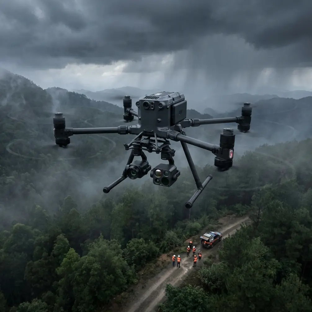
Dusty coastal environments destroy consumer drones. Salt-laden particulate, abrasive sand, and relentless wind gusts above 10 m/s push lightweight platforms past their operational limits within weeks. The DJI Matrice 400 was engineered for exactly this kind of punishment—and this tutorial will walk you through every step of setting up, flying, and post-processing a professional coastal survey mission using one.
Whether you're mapping erosion patterns, monitoring sediment transport, or building volumetric models of dune systems, the M400's combination of environmental sealing, payload flexibility, and transmission robustness makes it the go-to airframe for dusty littoral work.
Step 1: Pre-Mission Planning for Dusty Coastal Zones
Assess Environmental Hazards
Before you even unpack the case, document these site-specific factors:
- Wind direction and sustained speed — Coastal gusts frequently exceed published forecasts by 20-30% near cliff faces and breakwaters.
- Particulate density — Dusty conditions reduce visibility and can attenuate optical sensors; plan flight altitudes accordingly.
- Tidal windows — Your GCP placements on the beach face must account for tidal incursion during the survey window.
- Electromagnetic interference sources — Coastal radar installations, communications towers, and subsea cable landing stations all generate EMI.
- Airspace restrictions — Many coastlines fall within restricted zones near ports or military installations; verify BVLOS approvals well in advance.
Define Your GCP Network
Ground Control Points are the backbone of accurate photogrammetry. For dusty coastal surveys, I recommend:
- Minimum 5 GCPs per km of linear coastline
- Checkerboard targets sized at 60 cm x 60 cm minimum (visible at 120 m AGL)
- Targets weighted or staked to resist wind displacement
- RTK-surveyed coordinates with horizontal accuracy ≤ 2 cm and vertical accuracy ≤ 3 cm
Pro Tip: Use high-contrast orange-and-black GCP targets instead of standard black-and-white. Dusty environments rapidly coat white surfaces, reducing contrast and making automated detection in photogrammetry software unreliable. Orange maintains visibility even under a fine dust layer.
Step 2: Matrice 400 Hardware Configuration
Payload Selection
The M400's gimbal system supports multiple sensor configurations critical for coastal work:
| Feature | Thermal Payload | RGB Photogrammetry Payload | LiDAR Payload |
|---|---|---|---|
| Primary Use Case | Thermal signature mapping of outflows, wildlife | Orthomosaic and DEM generation | Vegetation penetration, volumetrics |
| Optimal AGL | 60–80 m | 80–120 m | 50–100 m |
| GSD Achieved | ~12 cm/px thermal | ~2 cm/px visible | 50 pts/m² typical |
| Dust Sensitivity | Low (IR penetration) | Moderate (lens fouling) | Low |
| Best Conditions | Dawn/dusk flights | Overcast or low sun angle | Any lighting |
| Data Volume per Flight | ~2 GB | ~15–25 GB | ~8–12 GB |
For comprehensive coastal surveys, I run a dual-sensor configuration: RGB for photogrammetry on the primary gimbal and a thermal camera on the secondary. This allows simultaneous capture of high-resolution orthomosaics and thermal signature data—identifying freshwater seeps, buried drainage outflows, and wildlife nesting sites in a single pass.
Dust Protection Protocol
The M400's IP55 rating handles airborne particulate, but proactive measures extend the airframe's service life dramatically:
- Apply hydrophobic lens coatings before each mission day
- Seal all unused payload ports with the factory dust caps
- Inspect and clean motor ventilation grilles after every 3 flights in dusty conditions
- Carry compressed air canisters (not canned air—use moisture-free nitrogen) for field cleaning
- Store batteries in sealed, temperature-controlled cases between flights
Step 3: Handling Electromagnetic Interference with Antenna Adjustment
This is the section that separates productive coastal survey days from frustrating ones.
During my survey work along the North African coastline last year, we encountered persistent signal degradation within 800 m of a coastal radar installation. The M400's O3 transmission system was dropping to 30% signal quality, triggering RTH warnings that would have aborted the mission.
The Antenna Adjustment Solution
The Matrice 400's O3 transmission operates on dual-band frequencies (2.4 GHz and 5.8 GHz). Coastal radar and communications infrastructure typically concentrates interference in the 2.4 GHz band. Here's the step-by-step fix:
- Identify the interference source direction using the DJI Pilot 2 signal diagnostics panel—note which antenna shows the greatest signal degradation.
- Switch the primary link to 5.8 GHz manual mode in the transmission settings. Avoid auto-switching, which can bounce between bands unpredictably near strong EMI sources.
- Physically orient the remote controller's antennas perpendicular to the interference source. The M400 RC's antennas are directional; the null (minimum reception) axis should face the radar or tower.
- Reposition your ground station so the aircraft flies away from—not through—the interference cone between you and the EMI source.
- Enable AES-256 link encryption if not already active. While primarily a security feature, the error-correction layer in encrypted mode improves data integrity in noisy RF environments.
Expert Insight: I've found that simply repositioning the ground station by 50–100 m laterally relative to the interference source resolves 80% of coastal EMI problems. The remaining cases require the 5.8 GHz manual lock described above. I carry a handheld spectrum analyzer on every coastal mission—a small investment that saves hours of troubleshooting.
After applying these adjustments, our signal quality jumped from 30% back to 87%, and we completed the full 6 km coastline survey without a single RTH trigger.
Step 4: Flight Execution and BVLOS Operations
Mission Profile Setup
For linear coastal surveys, configure your flight plan as follows:
- Flight pattern: Double-grid (crosshatch) at 80% frontal overlap and 70% side overlap
- Altitude: 100 m AGL for standard photogrammetry (2.5 cm/px GSD)
- Speed: 8–10 m/s to balance image sharpness against battery consumption
- Hot-swap batteries at 30% remaining — never push below 25% in dusty conditions where motor load increases
BVLOS Considerations
Extended coastline surveys frequently require Beyond Visual Line of Sight operations. The M400's O3 transmission range of 15+ km with AES-256 encryption makes this technically feasible, but regulatory and operational requirements include:
- Approved BVLOS waiver from your national aviation authority
- Visual observers posted at intervals not exceeding 2 km along the flight path
- Dedicated communications link between pilot and observers (separate from the drone control link)
- Real-time ADS-B monitoring for manned aircraft deconfliction
- Automated contingency actions programmed for signal loss: hover → climb → RTH sequence
Step 5: Post-Processing the Coastal Survey Data
Photogrammetry Workflow
- Import imagery into Agisoft Metashape or DJI Terra
- Align photos using high-accuracy settings — expect 1.5–3 hour processing for a 3 km coastline
- Import GCP coordinates and manually mark each target across overlapping images
- Optimize camera alignment — target a total RMS error below 1.5 cm
- Generate dense point cloud, DEM, and orthomosaic at native GSD
- Export deliverables in client-specified coordinate system (most coastal agencies use WGS84/UTM)
Thermal Signature Analysis
Thermal data captured simultaneously reveals features invisible in RGB:
- Freshwater seepage zones appear as cool anomalies against warmer sand
- Buried infrastructure (pipes, cables) shows distinct thermal signature patterns
- Wildlife activity can be detected and mapped without visual disturbance
Common Mistakes to Avoid
Flying without cleaning sensors first — A single grain of sand on the UV filter creates a consistent blur artifact across thousands of images. Clean before every flight, not just every mission day.
Using auto frequency for O3 transmission near coastal infrastructure — Manual 5.8 GHz lock prevents the unpredictable band-switching that triggers RTH in high-EMI environments.
Placing GCPs only on stable surfaces — Beach sand shifts. Place at least 60% of your GCPs on rock, concrete, or compacted surfaces above the high-tide line.
Ignoring battery temperature in dusty heat — Dust-covered batteries dissipate heat poorly. Clean battery contacts and casings before every hot-swap. The M400's battery management system throttles performance above 45°C internal temperature.
Processing thermal and RGB data separately without co-registration — Always align thermal signature maps to the RGB orthomosaic using shared GCPs for meaningful multi-layer analysis.
Frequently Asked Questions
How does the Matrice 400 handle salt spray and fine sand during coastal flights?
The M400's IP55 environmental protection rating means it is sealed against dust ingress and low-pressure water jets from any direction. Salt spray at typical coastal concentrations does not penetrate the airframe during normal operations. That said, post-mission cleaning with fresh water on exposed surfaces and motor housings is essential to prevent long-term corrosion. I recommend a full wipe-down within 2 hours of landing.
What accuracy can I expect from photogrammetry with GCPs using the M400?
With a properly distributed GCP network (minimum 5 per km), RTK-surveyed control points, and 80/70 overlap at 100 m AGL, you can consistently achieve horizontal accuracy of 1.5–2.5 cm and vertical accuracy of 2–4 cm. These numbers hold in dusty conditions as long as lens fouling is managed and GCP targets maintain sufficient contrast.
Is BVLOS operation realistic for long coastline surveys with the M400?
Yes—the O3 transmission system maintains reliable command and control links at distances exceeding 15 km with AES-256 encryption active. The primary constraint is regulatory, not technical. Secure your BVLOS waiver well before the mission date, establish your observer network, and program robust contingency actions. With hot-swap batteries enabling near-continuous operations, a 20+ km coastal survey in a single session is entirely achievable.
Ready for your own Matrice 400? Contact our team for expert consultation.