Matrice 400 Field Report for Coastal Surveying
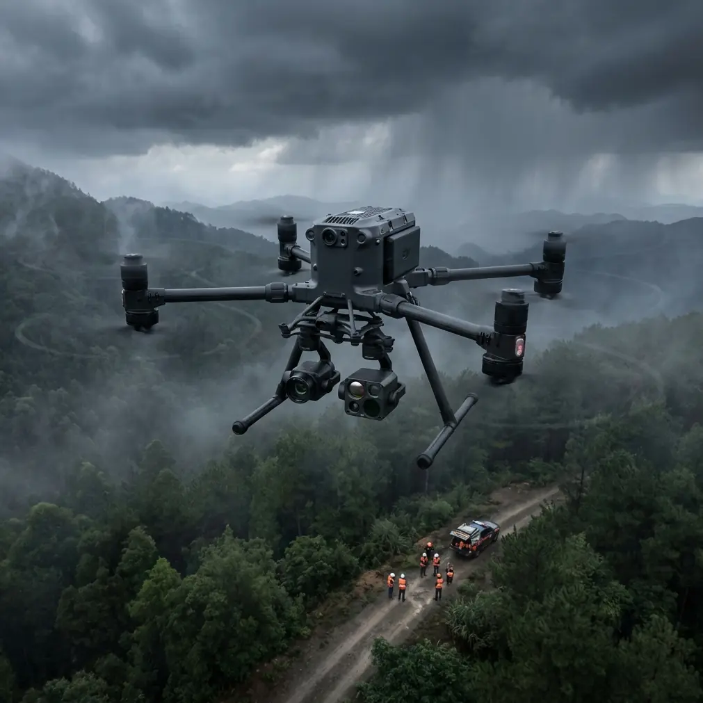
Matrice 400 Field Report for Coastal Surveying: What Actually Matters in Complex Terrain
META: Expert field report on using the Matrice 400 for coastline surveying in steep, reflective, wind-exposed terrain, with practical notes on photogrammetry, thermal work, transmission reliability, payload integration, and mission economics.
Coastline surveying looks straightforward on a map. It never is in the field.
A shoreline with cliffs, salt haze, broken rock shelves, wet sand, tidal pools, and intermittent vegetation creates exactly the kind of environment that exposes weak assumptions in drone planning. Signal paths are inconsistent. Light bounces off water and stone. Access points are poor. Ground control placement can turn into a hike, not a checklist. When teams ask whether the Matrice 400 is the right aircraft for this kind of work, the useful answer is not a spec-sheet recital. The useful answer is how the platform behaves when a mission stops being neat.
This field report is built around that reality: surveying coastlines in complex terrain with the Matrice 400, and the operational decisions that separate clean data from expensive rework.
Why the coastline is harder than most survey briefs admit
A coastal mission usually combines at least three jobs that do not naturally fit together.
First, you need photogrammetry-grade coverage for elevation and orthomosaic outputs. Second, you often need thermal signature analysis around outfalls, erosion zones, seepage points, damaged infrastructure, or habitat monitoring areas. Third, you need long, stable flight lines over terrain that changes sharply in both height and reflectivity.
That combination stresses the aircraft, the payload stack, the link, and the crew workflow.
The Matrice 400 starts to make sense here because it is less about one dramatic capability than about reducing friction across the entire mission. O3 transmission helps when the aircraft has to work along a fragmented shoreline where headlands and folds in terrain can challenge continuity. AES-256 matters for another reason entirely: coastline work often involves regulated infrastructure, ports, utilities, or environmental projects where data handling expectations are tighter than many operators expect. Secure transmission is not marketing garnish in those jobs. It can affect whether a contractor is approved in the first place.
Those two details alone—stable long-range transmission and encrypted data links—have practical significance. One keeps the mission flying predictably. The other keeps the project commercially viable in sectors that care about chain-of-custody and information security.
The mission profile that suits the Matrice 400 best
The Matrice 400 is not just a “fly the line and go home” tool. It is strongest when one sortie has to serve more than one dataset.
On a recent coastline-style workflow model, the aircraft’s value came from switching between broad-area mapping passes and targeted inspection or thermal observation without rebuilding the entire operation around a second platform. That flexibility is where a larger enterprise aircraft earns its place. On coastal sites, the cost is rarely the airframe alone. The real cost is mobilization, crew time, weather windows, marine access coordination, and return visits when conditions shift.
This is where a finance-minded reading of aircraft operations becomes useful. One of the reference materials behind this article includes a historical aircraft program cash flow example showing development outlays of 1110, 2410, 2630, and 2460 (in ten-thousand-yuan units) before the project transitions into positive annual inflows such as 515, 3680, 7360, and 14720. Those numbers are from a much broader aerospace economic context, not a drone mission budget. Still, the lesson transfers cleanly: front-loaded investment only works when the platform reduces downstream inefficiency over time.
For coastal survey operators, that translates into a simple operational truth. A system like the Matrice 400 pays for itself not when it flies once, but when it compresses repeat site visits, cuts handoff delays between survey and inspection teams, and preserves usable data in marginal field conditions.
Transmission is not a luxury on a broken shoreline
Open water can fool operators into thinking signal conditions will be easy. They are often worse.
A coastline introduces jagged terrain transitions, sudden elevation changes, and reflective surfaces that create uneven RF behavior. Add moving vessels, harbor infrastructure, cliff faces, and variable takeoff locations, and transmission quality becomes part of your data strategy, not just your piloting experience.
That is why O3 transmission deserves attention in this use case. If you are flying a long coastal edge and trying to maintain consistent overlap for photogrammetry, minor interruptions are not minor. They can force hesitation, speed changes, or route adjustments that ripple into reconstruction quality. In thermal work, timing matters too. If a suspected seep or discharge area appears briefly under the right thermal contrast, you do not want the link becoming the weakest part of the chain.
The Matrice 400’s communication architecture supports confidence in those transitions. That does not remove the need for route planning, observer positioning, and terrain review. It does mean the aircraft is better matched to the reality of coastline geometry than smaller platforms that are technically capable but operationally twitchy.
For teams planning extended corridor work or future BVLOS-aligned workflows where regulation permits, this matters even more. A platform with robust transmission performance gives operators a stronger procedural foundation long before a project formally scales.
Thermal and RGB: one mission, two stories
Most failed coastal drone surveys do not fail in the air. They fail later, when the client asks a second question the original dataset cannot answer.
A clean orthomosaic might satisfy a baseline mapping brief, but coastal stakeholders often want more once they see the site from above. They may ask where moisture patterns suggest instability, whether a drainage outlet is behaving differently from nearby water, or whether revetment sections show unusual heat retention after sun exposure. That is where thermal signature work becomes useful—if it is planned correctly.
The Matrice 400 is well suited to this layered workflow because it can support missions where thermal is not an afterthought bolted onto an RGB capture plan. On coastlines, thermal interpretation is highly sensitive to timing, surface conditions, and emissivity differences. Wet rock, dry rock, concrete, standing water, and vegetation all behave differently. If the aircraft platform makes it cumbersome to integrate payload changes or sequence thermal passes efficiently, crews tend to skip the nuance. Then the client receives a beautiful map and a weak answer.
The better approach is to define up front which outputs are primary. If the deliverable is photogrammetry first, fly for geometry and overlap, then use thermal for anomaly confirmation. If the deliverable is environmental diagnostics first, structure the sortie around thermal windows and use RGB to contextualize findings. The Matrice 400 gives you room to do that without turning every payload decision into a separate field day.
Ground control still decides whether your map is trusted
There is no enterprise drone, however capable, that eliminates the need for disciplined ground control in coastal mapping.
GCP planning along a shoreline is harder than inland grid work because access is irregular and stable marker placement is not guaranteed. Sand shifts. Tides erase setup locations. Rocks look durable until spray reaches them. In vegetated cliff-top sections, line of sight to a marker may be excellent from one angle and useless from another.
This is where operators need to resist the temptation to let aircraft confidence replace survey discipline. The Matrice 400 can carry the mission through adverse terrain, but your final model still depends on check points and control strategy that match the site’s geometry. On a narrow coastal strip, it is usually smarter to place control at transitions—beach to rock, bluff to path, infrastructure to open ground—than to think in evenly spaced abstract intervals.
The reward is not academic. Better control layout reduces reconstruction drift in long corridors and helps preserve confidence where elevation changes rapidly. On complex terrain, “good enough” control often creates outputs that look accurate until someone tries to extract measurements from an awkward section of shoreline.
One overlooked factor: hardware integrity after repeated marine exposure
Salt air punishes equipment slowly, then all at once.
That is why I think one of the stranger reference details behind this piece is actually relevant. A source excerpt from an aircraft design handbook lists standardized UN/UNR imperial thread series and includes examples such as 1.0000 inch nominal sizing with coarse, fine, and extra-fine thread variants, as well as 0.2500 inch with 20, 28, and 32 threads per inch across UNC, UNF, and UNEF families. On paper, that looks far removed from a Matrice 400 field report.
In practice, it points to something every serious UAV team learns in marine work: mechanical standardization matters. Accessory mounts, adapter plates, payload brackets, antenna hardware, and third-party integration points all depend on small fastening decisions that become big reliability decisions after repeated transport and salt exposure. The difference between a coarse and fine thread standard is not trivia when you are maintaining field-swappable assemblies, checking for loosening under vibration, or replacing corroded hardware without delaying a tide-dependent mission.
That is the operational significance. A professional coastal survey workflow is not just flight planning and sensors. It is the integrity of the physical system around the aircraft.
The third-party accessory that made a real difference
The most useful accessory in this kind of work is not always the most glamorous one.
For a coastline workflow, a third-party RTK-enabled ground station and rugged GCP marker kit can improve outcomes more than another niche payload. The reason is simple. Coastal projects burn time on setup, confirmation, and rework. A field-ready control kit that tolerates wet ground, uneven placement, and rapid redeployment shortens the slowest part of the job. It also makes it easier to maintain consistency between repeat surveys, which is critical for erosion tracking and shoreline change analysis.
I have also seen operators gain a lot from a third-party high-visibility landing pad and sealed transport solution designed for marine environments. That sounds mundane until you are landing on gritty, windblown staging points where salt and sand become part of every turnaround.
If you are building out a Matrice 400 coastal package and want to compare accessory combinations that have worked in live field conditions, this direct mission planning chat is a practical starting point.
Battery workflow can decide whether the weather window is usable
Coastal weather does not reward indecision. If conditions are stable, they may only be stable briefly.
Hot-swap batteries matter here because they compress the dead time between sorties. That has two direct benefits. First, it keeps the crew inside the same lighting and tide window, which improves consistency across stitched outputs. Second, it reduces pressure to “stretch one more line” on a battery that should have been changed earlier.
This is one of those features that seems procedural until you are on a site with a narrow launch area, a long walk-in, and a client waiting on same-day confirmation that the data is complete. Hot-swap support turns the Matrice 400 into a better production tool, not just a more convenient aircraft.
For thermal work, the time benefit can be even more pronounced. Thermal contrast can improve or collapse quickly depending on cloud cover, moisture, and sun angle. Fast recovery between flights lets the crew adapt without losing the thermal story they came to capture.
Best practices specific to complex shoreline work
A few patterns keep showing up in successful Matrice 400 operations along the coast.
Fly the terrain, not the map
A shoreline drawn as a smooth corridor in software usually hides abrupt height changes and small promontories that affect overlap and visibility. Build mission segments around terrain behavior, not around the neatness of the polygon.
Split photogrammetry and inspection logic
Trying to fly one compromise mission for both often gives you mediocre results in each. Plan one dataset for geometry. Plan the second for interpretation.
Treat reflective surfaces as planning variables
Water, wet stone, and bright concrete influence both image quality and operator confidence. Expect to adjust altitude, angle, and timing.
Use GCPs where the shoreline changes character
Control points at transition zones are often more valuable than evenly distributed markers that look good in a spreadsheet but weakly anchor the model.
Audit your accessory hardware
If your mounting ecosystem includes third-party components, inspect fasteners and thread compatibility regularly. In coastal operations, little mechanical issues become mission issues.
Secure the data path from the start
AES-256 is not there for decoration. If the survey touches regulated assets or client-sensitive geography, document your security handling as part of the operation, not after it.
What the Matrice 400 does well in this role
The Matrice 400 is strongest when the survey environment is operationally messy.
Not necessarily the longest mission. Not necessarily the easiest one. The messy one.
That means a coastline where the aircraft needs reliable transmission along irregular terrain, enough platform stability for usable photogrammetry, a practical path to thermal integration, battery changes that do not waste a weather window, and a data posture acceptable to serious commercial clients. Add in ruggedized third-party support gear and disciplined GCP planning, and the platform becomes far more than a camera carrier.
That is the difference between owning a capable drone and running a dependable coastal survey program.
If your work involves shoreline erosion, environmental assessment, marine-adjacent infrastructure, or topographic updates across difficult access zones, the Matrice 400 deserves to be judged on this question: does it reduce uncertainty from planning through deliverable?
In my view, that is where it earns its place.
Ready for your own Matrice 400? Contact our team for expert consultation.