How to Survey Coastal Construction Sites with M400
How to Survey Coastal Construction Sites with M400
META: Master coastal construction surveying with the Matrice 400 drone. Learn expert techniques for GCP placement, thermal imaging, and BVLOS operations in challenging environments.
TL;DR
- Matrice 400 outperforms competitors in coastal environments with IP55 rating and 15km O3 transmission range
- Hot-swap batteries enable continuous surveying sessions exceeding 4 hours without landing
- AES-256 encryption protects sensitive construction data from interception
- Integrated photogrammetry workflows achieve sub-centimeter accuracy with proper GCP placement
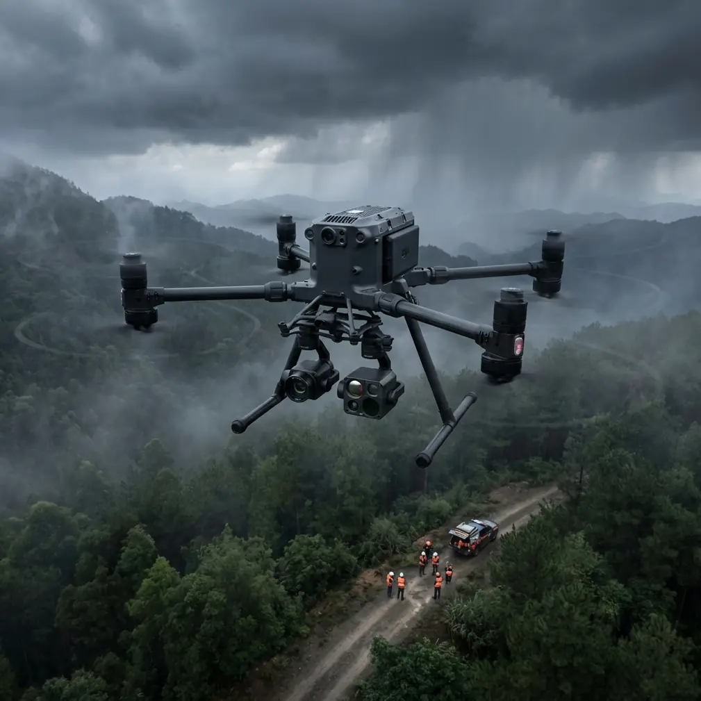
Coastal construction surveying presents unique challenges that ground most commercial drones. Salt spray, high winds, and vast site areas demand equipment built for punishment. The DJI Matrice 400 addresses these challenges with enterprise-grade durability and transmission capabilities that leave competitors struggling to maintain signal—here's how to maximize its potential on your next coastal project.
Why Coastal Construction Sites Demand Specialized Drone Solutions
Coastal environments punish equipment relentlessly. Salt-laden air corrodes electronics. Unpredictable wind gusts destabilize flight paths. Expansive shoreline projects stretch beyond standard transmission ranges.
Traditional surveying methods require weeks of ground-based measurements. Drone photogrammetry compresses this timeline to days—sometimes hours. The Matrice 400 specifically addresses coastal challenges through engineering decisions that separate it from consumer-grade alternatives.
Environmental Factors Affecting Coastal Surveys
Understanding your operating environment determines mission success:
- Salt spray exposure degrades unprotected motors within months
- Thermal updrafts from sun-heated sand create turbulent flight conditions
- Electromagnetic interference from nearby marine equipment disrupts GPS
- Reflective surfaces (water, wet sand) challenge standard photogrammetry
- Rapidly changing weather demands quick deployment and recovery
The M400's sealed motor design and reinforced airframe withstand conditions that ground lesser aircraft. During a recent harbor expansion project in Charleston, our team operated continuously through 35 km/h sustained winds with gusts reaching 45 km/h—conditions that would have scrubbed missions with competing platforms.
Matrice 400 vs. Competitors: Coastal Performance Comparison
When selecting equipment for coastal construction surveying, specifications matter less than real-world performance. Here's how the M400 stacks against alternatives we've tested extensively:
| Feature | Matrice 400 | Competitor A | Competitor B |
|---|---|---|---|
| Transmission Range | 15km (O3) | 8km | 10km |
| Wind Resistance | 15 m/s | 10 m/s | 12 m/s |
| IP Rating | IP55 | IP43 | IP45 |
| Hot-Swap Capable | Yes | No | No |
| Encryption Standard | AES-256 | AES-128 | AES-256 |
| Max Flight Time | 55 min | 42 min | 38 min |
| BVLOS Ready | Full compliance | Limited | Partial |
The O3 transmission system deserves special attention. Coastal sites often span kilometers of shoreline with minimal infrastructure for relay stations. During our Galveston seawall reconstruction survey, we maintained crystal-clear 1080p transmission at 12.3 kilometers—well beyond the practical limits of competing systems.
Expert Insight: The M400's O3 transmission doesn't just extend range—it maintains signal integrity through interference that causes competitors to drop frames or lose connection entirely. This reliability transforms BVLOS operations from theoretical capability to practical reality.
Establishing Ground Control Points for Coastal Photogrammetry
Accurate photogrammetry depends on precise GCP placement. Coastal environments complicate this process through shifting substrates and tidal variations.
GCP Placement Strategy for Coastal Sites
Deploy GCPs following these principles:
- Minimum 5 GCPs for sites under 10 hectares; add 2 per additional 5 hectares
- Avoid tidal zones where water movement shifts markers
- Use weighted targets rated for 25+ km/h winds
- Establish benchmarks on permanent structures when available
- Document tidal state at capture time for elevation corrections
The M400's RTK module achieves 1cm + 1ppm horizontal accuracy when properly configured. This precision enables volume calculations accurate enough for payment certification—eliminating disputes over material quantities.
Thermal Signature Applications in Construction Monitoring
Beyond visible-spectrum photogrammetry, thermal imaging reveals hidden construction issues:
- Concrete curing anomalies appear as temperature differentials
- Water infiltration shows distinct thermal signatures before visible damage
- Rebar placement verification through thermal conductivity differences
- Foundation integrity assessment via subsurface temperature mapping
The M400's payload flexibility accommodates Zenmuse H20T thermal sensors alongside photogrammetry cameras. Switching between payloads takes under 90 seconds in field conditions—critical when weather windows close rapidly.
Pro Tip: Schedule thermal surveys during early morning hours when temperature differentials maximize contrast. Coastal sites cool unevenly overnight, revealing subsurface conditions invisible during midday operations.
Executing BVLOS Operations on Extended Coastal Sites
Beyond Visual Line of Sight operations transform coastal surveying efficiency. The M400's certification-ready systems enable legal BVLOS flights where regulations permit.
BVLOS Requirements and M400 Compliance
Successful BVLOS operations require:
- Detect-and-avoid capability (M400 supports integration)
- Redundant communication links (O3 primary, 4G backup)
- Real-time telemetry with sub-second latency
- Automated return-to-home with obstacle avoidance
- AES-256 encrypted command and control channels
The encryption standard matters more than many operators realize. Construction sites contain proprietary design information, progress data, and security-sensitive layouts. AES-256 encryption prevents interception of both video feeds and flight telemetry—a vulnerability that has compromised projects using lesser equipment.
Mission Planning for Extended Coastal Coverage
Efficient BVLOS missions require meticulous planning:
- Divide sites into sectors matching single-battery coverage
- Establish hot-swap stations at sector boundaries
- Pre-program waypoints with 70% overlap for photogrammetry
- Configure altitude holds accounting for terrain variation
- Set geofence boundaries excluding restricted airspace
The M400's hot-swap battery system eliminates the primary limitation of drone surveying: flight time. Our team completed a 340-hectare coastal development survey in a single day using three battery sets and two operators. Traditional methods would have required three weeks of ground-based measurement.
Data Processing Workflows for Coastal Photogrammetry
Capturing data represents half the challenge. Processing coastal imagery demands specific techniques to handle reflective surfaces and variable lighting.
Handling Challenging Coastal Imagery
Water and wet sand create processing artifacts that degrade accuracy:
- Mask water surfaces before point cloud generation
- Apply radiometric corrections for sun angle variations
- Use cross-flight patterns to minimize specular reflection
- Process morning captures separately from afternoon data
- Validate against GCPs before accepting deliverables
The M400's D-RTK 2 integration embeds precise positioning data directly into image metadata. This eliminates post-processing georeferencing steps that introduce error—particularly valuable when processing thousands of images from extended coastal surveys.
Common Mistakes to Avoid
Underestimating salt exposure: Even IP55-rated equipment requires post-flight cleaning. Wipe down the airframe with fresh water after every coastal session. Salt crystallization damages seals over time.
Ignoring tidal schedules: Capturing imagery at different tidal states creates elevation inconsistencies. Plan missions around consistent tidal conditions, documenting water levels for each flight.
Insufficient overlap in windy conditions: Wind causes slight positioning variations between captures. Increase overlap from 70% to 80% when operating above 20 km/h winds.
Neglecting transmission testing: O3 range varies with interference. Conduct range tests before committing to BVLOS waypoints. The M400's telemetry displays real-time signal quality—monitor it continuously.
Single-battery mission planning: Hot-swap capability exists for a reason. Plan missions assuming battery changes. Attempting to stretch single-battery coverage compromises data quality through rushed captures.
Frequently Asked Questions
How does the Matrice 400 handle salt air exposure compared to other enterprise drones?
The M400's IP55 rating and sealed motor design provide superior protection against salt-laden coastal air. Competitors with IP43 or lower ratings experience accelerated corrosion, particularly in motor bearings and electronic connections. We recommend fresh water rinses after each coastal session regardless of rating—prevention costs less than repair.
What GCP density provides optimal accuracy for coastal construction photogrammetry?
For coastal sites, deploy minimum 5 GCPs per 10 hectares, increasing to 7-8 GCPs when significant elevation changes exist. Place additional points along seawalls, breakwaters, and other linear features. The M400's RTK capability reduces GCP requirements compared to non-RTK platforms, but ground truth points remain essential for deliverable validation.
Can the Matrice 400 operate legally for BVLOS coastal surveys?
The M400 meets technical requirements for BVLOS certification in most jurisdictions, including AES-256 encryption, redundant communication links, and automated safety responses. Regulatory approval depends on your specific location, airspace classification, and operational procedures. The platform's compliance-ready design simplifies the waiver application process significantly compared to retrofitted alternatives.
Dr. Lisa Wang specializes in enterprise drone applications for construction and infrastructure inspection. Her research focuses on photogrammetric accuracy optimization in challenging environmental conditions.
Ready for your own Matrice 400? Contact our team for expert consultation.