Matrice 400 Field Report: What Changed on Remote
Matrice 400 Field Report: What Changed on Remote Construction Surveys
META: A specialist field report on using Matrice 400 for remote construction site surveying, with practical insight on power continuity, fire-system thinking, thermal workflows, and why resilient design matters in the field.
Remote construction surveys rarely fail because of one dramatic event. They fail through accumulation.
A ridge blocks transmission for a few seconds. A battery swap costs the best light of the day. Heat shimmer over rebar degrades edge detail in the orthomosaic. A thermal pass flags a hotspot, but the crew cannot confirm whether it came from curing concrete, overloaded temporary power gear, or a generator enclosure that simply needed better ventilation.
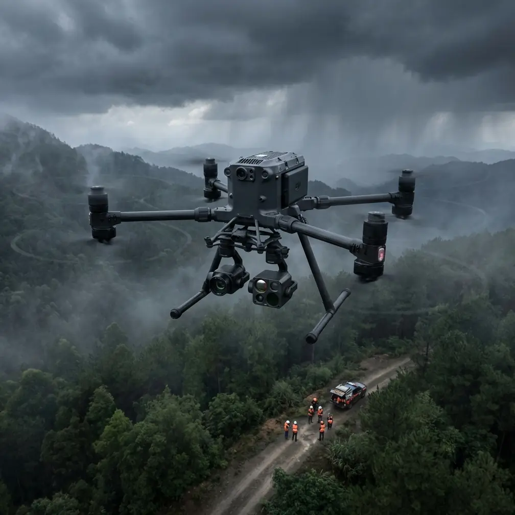
That is the context where the Matrice 400 matters.
I have spent enough time on isolated job sites to know that airframe specs alone do not tell the real story. What matters is whether the aircraft helps you preserve continuity under stress: stable flight, stable sensing, stable power, stable decision-making. For remote construction work, especially when the mission combines photogrammetry, thermal signature review, and progress validation against GCP-backed site control, resilience becomes the actual product.
The Matrice 400 sits in that conversation not as a generic “better drone,” but as a platform that reduces the number of weak links in a difficult survey chain.
A lesson from older aircraft design still applies
One reason I evaluate survey platforms differently today comes from studying legacy aircraft engineering methods rather than drone marketing sheets.
In one propulsion-system design reference, fire-system validation is not treated as a vague pass/fail exercise. The test setup is deliberately controlled. Fuel is fed into the fire source at a defined rate of 20 to 25 units per second, pressure is determined by compartment free volume, and the system is judged by whether a single extinguishing action sustained for 10 seconds can suppress the developed fire. The test conditions also require temperature and cooling airflow that represent actual in-flight operating conditions.
That level of rigor matters to drone operators even if we are not running manned-engine fire tests.
Why? Because it teaches a discipline that remote construction teams often miss: field reliability must be evaluated under realistic thermal, ventilation, and power conditions, not under ideal demo conditions. If a platform claims operational durability, the right question is not whether it works on a calm morning near the office. The right question is whether it holds sensing quality and mission continuity when ambient heat, payload load, and repeated flight cycles interact in ways the spec sheet barely hints at.
On a remote construction site, the drone may not face engine-compartment fire certification, but it absolutely faces the same engineering principle: systems must be validated under representative environmental stress. For the Matrice 400, that changes how I plan sorties. I care about thermal management during repeated mapping legs, payload behavior after several battery cycles, and whether the aircraft maintains consistent output when the site itself is radiating heat from steel, asphalt, generators, and temporary electrical equipment.
Why power continuity is the hidden survey bottleneck
The second reference point comes from aircraft electrical-system design. It discusses dedicated power supplies, uninterrupted power, and fault isolation. One section highlights that protection devices must detect generator or grid faults, isolate the faulty portion, and prevent the problem from cascading across the rest of the supply system. Another example describes specialized power architectures such as 115/200 V, 400 Hz, three-phase supply arrangements and backup pathways for critical control loads.
Again, this is not directly about a drone battery pack. But the operational lesson is extremely relevant.
Remote construction surveying is a power-quality problem disguised as an imaging task.
If you are capturing high-overlap photogrammetry in the morning, then switching to a thermal signature inspection around temporary substations or site cabins by midday, your workflow depends on clean continuity. Interruptions corrupt more than flight time. They break comparison logic between passes. They create gaps in overlap. They force crews to re-establish flight rhythm and often re-check GCP visibility. In complex terrain, that can mean a second hike to a launch point that should never have been necessary.
This is where hot-swap batteries are more than a convenience feature. They support the same design philosophy seen in larger aircraft power systems: protect continuity, isolate disruption, and keep the critical mission sequence alive.
On the Matrice 400, that matters most when the site is too remote to tolerate reset-heavy operations. If the aircraft can preserve workflow across battery events, operators spend less time rebuilding context. That directly improves map consistency, especially on long corridor sections, large material yards, or phased earthworks where timing differences change surface appearance and shadow geometry.
The challenge that changed my process
A few seasons ago, I was supporting a survey team on a remote construction package where access roads were still temporary and site power was unstable. The mission sounded straightforward: produce a photogrammetric model for cut-and-fill verification, add thermal checks on mobile generators and temporary switchgear, and document drainage grading before a weather front moved in.
On paper, easy.
In reality, every weakness surfaced at once. Transmission dropped when the aircraft passed behind a spoil berm. The thermal pass had to be repeated because the first battery swap interrupted our sequence and shifted surface heating conditions. We had GCPs in place, but the team lost confidence in one section of the model because the timing gap introduced inconsistent shadows across stitched imagery.
That day changed how I think about integrated survey platforms.
With the Matrice 400, the conversation becomes less about one glamorous capability and more about how the stack behaves together: O3 transmission resilience over uneven terrain, secure data handling through AES-256 when project stakeholders are sensitive about infrastructure imagery, payload flexibility for thermal and visual capture, and battery architecture that allows the crew to hold the mission together instead of constantly restarting it.
None of those elements is exciting in isolation. Together, they are the difference between a same-day deliverable and a compromised dataset.
Thermal signature work is only useful if the platform supports context
Construction teams increasingly ask for thermal layers, but they often misunderstand what makes thermal actionable.
A hotspot by itself does not solve anything. What matters is whether the thermal signature can be interpreted alongside the geometric model and site conditions. Is the heat coming from normal curing, mechanical stress, overloaded electrical equipment, poor ventilation around a generator housing, or reflected solar gain from adjacent metal stock?
That old propulsion reference I mentioned earlier insists that test airflow and temperature must reflect real operating conditions. The same principle applies in drone thermography. If you fly thermal without considering ventilation paths, heat soak, and the timing of site operations, you are collecting colorized ambiguity.
The Matrice 400 is valuable here because it enables a tighter operational loop between thermal pass and visual confirmation. For remote sites, that means I can run thermal observations over generator zones, temporary electrical stations, asphalt staging, or enclosed plant equipment, then immediately pair those findings with higher-detail visual or oblique review to verify whether the anomaly is structural, electrical, or environmental.
This is particularly useful around temporary site power installations. Electrical-system design literature emphasizes fault detection and isolation for a reason: minor abnormalities can become larger system issues if they are not identified early. In a civilian construction setting, thermal drone inspection helps site managers catch imbalance, poor cooling, overloaded connectors, or enclosure heat buildup before downtime ripples into scheduling delays.
Photogrammetry quality depends on workflow discipline, not just camera quality
Plenty of teams assume a better aircraft automatically means a better model. It does not.
On large remote sites, photogrammetry rises or falls on repeatability. The Matrice 400 helps because it supports the boring parts of repeatability: stable mission execution, fewer interruptions, and smoother transitions between flights. When you pair that with properly marked GCPs, overlap discipline, and consistent altitude planning, you get data that can stand up to engineering review rather than just look impressive in a browser.
I tell teams to think in layers:
- The airframe protects continuity.
- The transmission link protects confidence.
- The battery system protects timing.
- The payload protects evidence.
- The GCP network protects truth.
Remove one, and the whole survey degrades.
That is why O3 transmission matters on remote construction sites. It is not a branding detail. In broken terrain, link quality affects operator confidence, and operator confidence affects mission consistency. A hesitant pilot makes more micro-corrections, more pauses, more conservative re-routing. That may be prudent, but it also introduces inconsistency into what should be a smooth mapping plan. A stronger and more reliable transmission environment reduces that friction.
Security is not a side issue on infrastructure-adjacent jobs
Many remote construction projects now involve sensitive layouts: energy assets, utility corridors, water infrastructure, logistics compounds, or private industrial developments. In those settings, secure handling of imagery is not just an IT footnote.
AES-256 matters because data protection has become part of operational professionalism. If you are surveying a site where subcontractors, EPC teams, and asset owners all touch the information chain, stronger encryption supports trust in the workflow. It helps answer a question clients increasingly ask before they ask about resolution: how is the data being protected?
That question used to come late in the engagement. Now it often arrives first.
For teams building remote survey operations around the Matrice 400, security settings should be configured as part of the standard mission template, not added after the first nervous client email.
Where BVLOS planning changes the value equation
I will stay inside civilian and commercial practice here: BVLOS planning, where permitted and properly authorized, changes the practical value of a long-endurance platform on linear and distributed construction packages.
Not because it sounds advanced, but because some sites are simply inefficient when forced into repetitive repositioning. Haul roads, pipeline spreads, utility alignments, and large staged developments all suffer when the crew spends more time leapfrogging launch points than collecting usable data.
The Matrice 400 becomes more useful when you view it as a continuity tool for these distributed environments. With disciplined mission design, clear airspace compliance, and appropriate operating approval, it can reduce the logistical drag that often dominates remote jobs more than flight performance itself.
What I would set up first on a real site
If I were deploying the Matrice 400 tomorrow on a remote construction survey, my first priorities would be practical:
- Build the mission around the site’s thermal cycle, not just the daylight window.
- Lock GCP placement before the first battery is installed.
- Separate photogrammetry and thermal objectives unless the site conditions truly support a combined run.
- Use hot-swap capability to preserve sequence continuity rather than rushing battery changes.
- Treat transmission planning as part of terrain analysis, especially near berms, stockpiles, and excavated cuts.
- Configure encryption and file-handling rules before capture starts.
- Reserve a short verification pass after the main mission to inspect anomalies while the context is still fresh.
That last step is one of the biggest improvements the Matrice 400 supports in practice. When a platform reduces operational friction, teams are more likely to complete the verification loop on the same visit instead of writing “recheck next trip” into the report.
And on remote sites, “next trip” is often where profit disappears.
The real advantage
After enough field cycles, I have stopped asking whether a drone is powerful. I ask whether it is forgiving.
Remote construction work punishes fragile workflows. The best survey platform is the one that keeps small disruptions from turning into data loss. The old aircraft references on fire testing and electrical protection may seem far removed from UAV site mapping, yet they point to the same truth: robust operations come from systems designed to perform under realistic stress, with continuity and fault isolation built into the philosophy.
That is the lens through which I see the Matrice 400.
It is not just about capturing imagery. It is about preserving mission integrity when the site is hot, far away, electrically messy, topographically awkward, and operating on a schedule that does not care how elegant your flight plan looked back at the office.
If your team is planning a remote surveying workflow and wants to compare payload strategy, thermal inspection sequence, or GCP layout logic for the Matrice 400, you can message Dr. Lisa Wang directly here.
Ready for your own Matrice 400? Contact our team for expert consultation.