Matrice 400 for Coastal Field Surveying: What Actually
Matrice 400 for Coastal Field Surveying: What Actually Matters in the Real World
META: Expert analysis of how the Matrice 400 fits coastal field surveying, with practical guidance on thermal work, photogrammetry, O3 transmission, AES-256 security, hot-swap batteries, GCP strategy, BVLOS planning, and third-party payload integration.
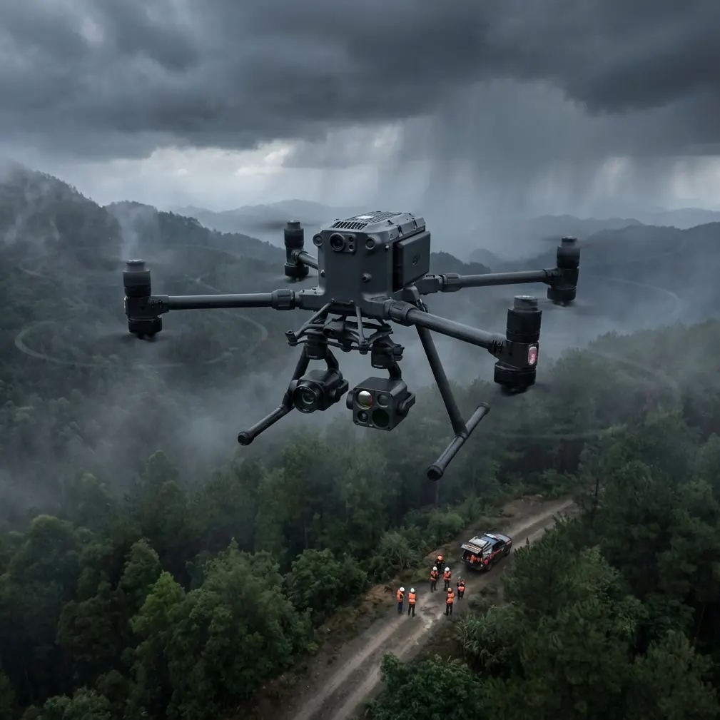
Coastal surveying has a way of exposing weak equipment fast. Salt in the air, flat light at dawn, reflective water, repetitive crop patterns, gusty wind over open ground, and long transit legs between field blocks all punish shortcuts. A drone that feels perfectly adequate inland can start showing limits the moment you move operations closer to the shoreline.
That is why the conversation around the Matrice 400 is more interesting than a simple platform comparison. For operators surveying fields in coastal environments, the real question is not whether the aircraft can fly. Plenty of aircraft can fly. The question is whether the platform can keep data quality, workflow speed, and operational continuity intact when conditions are less forgiving than the brochure scenario.
From that angle, the Matrice 400 stands out less as a generic “big enterprise drone” and more as a systems tool. It becomes valuable when you look at the exact field problems coastal teams run into and map them to payload flexibility, transmission reliability, battery strategy, geospatial discipline, and secure data handling.
The Coastal Survey Problem Is Not Just Wind
Most people reduce coastal drone work to wind resistance. Wind matters, of course, but that is only one layer of the problem.
In field surveying near the coast, operators often have to capture several kinds of information in one deployment window. Standard RGB imagery may be needed for orthomosaics and boundary verification. Thermal signature data may be useful for irrigation leaks, drainage anomalies, equipment heat patterns, or plant stress screening in selected scenarios. Then there is the issue of land geometry itself. Coastal fields are rarely as simple as they look from the road. Surface undulation, waterlogged margins, drainage cuts, levees, and access tracks all complicate mapping.
What makes this harder is that conditions can change mid-mission. Light shifts quickly over wet ground. Sea haze can reduce contrast. Repetitive crop texture can weaken tie point generation in photogrammetry if flight parameters are not thought through carefully. And when field parcels are spread out, battery handling and turnaround time stop being minor logistics and start shaping the entire day.
This is where the Matrice 400’s broader architecture matters.
Why the Matrice 400 Fits a Multi-Layer Survey Workflow
A coastal survey operation often needs one aircraft to support multiple mission types without introducing too much downtime between them. The Matrice 400 is best understood as a platform designed for exactly that kind of mixed workload.
Two details are especially significant here: hot-swap batteries and O3 transmission.
Hot-swap batteries are not just about convenience. In coastal field surveying, they reduce the dead time between sorties, which directly affects consistency. If you are trying to capture adjacent blocks under similar sun angle and atmospheric conditions, every unnecessary gap between flights introduces variability. Shorter turnaround means your photogrammetry runs are more uniform, your thermal comparisons are more defensible, and your crew spends less time rushing setup because the weather window is closing.
O3 transmission also carries operational significance beyond headline range discussions. Coastal terrain can be deceptively open, but signal conditions are not always perfect. Moisture, reflective surfaces, isolated infrastructure, and distance between staging points and target plots can all complicate control and video links. A stronger transmission ecosystem improves confidence when flying farther across large agricultural parcels or drainage corridors, particularly in workflows that may eventually align with tightly managed BVLOS planning where regulations and local approvals allow it. Even when the mission remains within visual line of sight, transmission robustness makes the operation calmer and more predictable.
Those two characteristics alone shift the aircraft from “capable” to “practical” for coastal survey crews.
Photogrammetry in Coastal Fields: Where Good Data Is Won or Lost
If your end product is an accurate map, digital surface model, drainage assessment, or crop-area calculation, the aircraft itself is only one part of the chain. The survey outcome depends on how well the platform supports disciplined photogrammetry.
Coastal fields create two recurring photogrammetry headaches. First, repetitive textures in crops can produce weak matching if overlap and angle strategy are not tuned properly. Second, low-contrast surfaces around wet margins or recently irrigated ground can degrade feature extraction. The Matrice 400’s value in this context comes from being able to carry higher-grade imaging options and maintain stable, repeatable flight performance over larger sites.
But the bigger point is this: with a platform like the Matrice 400, operators are less tempted to treat mapping as a quick automated task. The aircraft supports a workflow where you can plan for the site, not just the software defaults.
That means:
- setting overlap conservatively for repetitive crop rows,
- choosing flight times that reduce glare off wet soil,
- adding oblique capture where embankments or drainage channels matter,
- and most critically, using GCPs where the deliverable requires defensible positional accuracy.
A lot of field teams talk about RTK and onboard positioning as if they replace ground control altogether. In coastal survey work, that assumption can become expensive. GCPs still matter when boundaries, cut-and-fill estimates, drainage redesign, or engineering-grade interpretation are involved. The Matrice 400 helps because it can support a more serious geospatial workflow, but it does not eliminate the need for survey discipline.
If you are mapping fields that border channels, estuaries, or reclaimed land, ground control becomes even more valuable. Those transitional landscapes often contain subtle elevation behavior that matters greatly for water movement. A map that looks visually clean but lacks reliable control can lead to poor decisions.
Thermal Signature: Useful, but Only If You Respect Its Limits
Thermal is often brought into agricultural and land survey conversations in vague terms. That is a mistake. Thermal data is powerful when the operator knows exactly what the camera is being asked to reveal.
In coastal fields, a thermal signature can help identify irrigation irregularities, standing water zones, drainage failures, or stressed sections that are not obvious in RGB imagery. It can also support inspections around pump stations, storage areas, greenhouse edges, and related farm infrastructure. The Matrice 400’s advantage here is not simply that it can carry thermal-capable payloads. It is that it can integrate thermal collection into a broader mission set without forcing the team to mobilize a second aircraft for every specialized task.
That said, thermal is highly sensitive to timing, weather, and interpretation. A mid-afternoon flight over damp coastal ground may show temperature patterns driven more by surface heating differences than the operational issue you are trying to diagnose. Early morning or carefully chosen comparative windows often produce more useful results.
This is another place where battery workflow matters. With hot-swap batteries, crews can move from RGB mapping to a targeted thermal pass without losing momentum. That continuity can preserve the environmental conditions that make cross-comparison meaningful.
Security Matters More Than Many Farm Teams Realize
Large-field surveying is not only about agronomy or topography. Data governance increasingly matters, especially when work involves contract farming groups, land development interfaces, infrastructure adjacency, or clients who need tight control over imagery and location data.
The Matrice 400 discussion becomes more concrete when you bring in AES-256. For many operators, encryption sounds like an IT checkbox. In practice, it is part of professional risk control. Survey imagery can reveal field layouts, irrigation infrastructure, logistics routes, storage patterns, and business-sensitive land use decisions. Secure transmission and handling are not abstract enterprise features. They are a sign that the platform is suitable for organizations that cannot treat field data casually.
In coastal regions, that can matter for mixed-use areas where agriculture intersects with utilities, flood management assets, or private development zones. If your survey operation serves more than one stakeholder, secure workflows become part of credibility.
A Third-Party Accessory That Makes a Real Difference
One of the smartest ways to improve coastal field output is not changing the aircraft at all, but adding a quality third-party landing pad and ground station weather kit. It sounds unglamorous. It is not.
A weighted, elevated landing pad designed by a third-party accessory manufacturer can protect takeoff and landing in sandy, salty environments where rotor wash otherwise throws grit into the airframe and payload area. That small change reduces contamination risk and makes repeated battery swaps cleaner and faster. Pair that with a portable weather meter kit and your crew can document wind trends, humidity, and temperature shifts that explain both flight decisions and data anomalies.
This kind of accessory setup enhances the Matrice 400 because the platform is built for serious field operations. Once you have an aircraft capable of longer, more complex missions, small improvements around launch discipline, sensor cleanliness, and weather logging start paying out in better data consistency.
It is the difference between owning a powerful platform and actually operating it well.
BVLOS Potential Changes How You Think About Large Field Blocks
For scattered coastal properties, transit time is often the hidden cost in drone work. You may have one main field, then a drainage parcel, then another block beyond a road or canal. If local regulations, approvals, risk assessments, and operational controls permit BVLOS, a platform like the Matrice 400 becomes even more valuable because it aligns with larger-area mission planning.
The significance is not only range. It is workflow design. With a more robust aircraft and transmission system, crews can start structuring missions around property systems instead of isolated launch points. That means fewer compromises in overlap planning, fewer rushed repositioning breaks, and more consistent deliverables across connected land areas.
Even for operators not currently flying BVLOS, choosing an aircraft that supports that future matters. It gives the business room to expand into larger estates, drainage network surveys, linear agricultural infrastructure checks, and recurring seasonal mapping programs.
The Practical Setup I Would Recommend
If I were planning Matrice 400 operations for coastal field surveying, I would build the workflow around three priorities.
First, establish a repeatable photogrammetry template. Use tested overlap values, fixed flight altitudes matched to the output requirement, and a GCP plan that reflects the real precision needed by the client rather than the minimum needed to get a decent-looking map.
Second, separate broad mapping from targeted thermal work. Do not try to collect everything in one rushed mission profile. Use RGB to create the geospatial base, then fly thermal passes with a specific diagnostic question in mind.
Third, tighten your field procedures. Hot-swap batteries are only useful if battery rotation is organized. O3 transmission is only useful if antenna placement and launch site selection are thought through. AES-256 is only useful if your broader data workflow is disciplined as well.
That is usually where experienced operators distinguish themselves. Not in dramatic flying, but in boring consistency.
Final View: The Matrice 400 Makes Sense When the Job Is Bigger Than a Map
For coastal field surveying, the Matrice 400 is not interesting because it is large or new or enterprise-branded. It is interesting because the platform addresses the exact friction points that make coastal agricultural and land survey work difficult: long field legs, mixed sensor needs, battery downtime, data security, and the need for clean geospatial methods.
Its strongest case appears when you stop asking, “Can this drone survey a field?” and start asking, “Can this platform support a serious survey program across changing conditions, multiple payload needs, and larger property systems?”
That is the standard coastal operators should use.
If you are planning a setup around photogrammetry, thermal workflow, payload configuration, or compliant mission design, you can message a field specialist here to discuss how the platform fits your survey environment.
Ready for your own Matrice 400? Contact our team for expert consultation.