Matrice 400 Surveying in Windy Fields: A Practical Workflow
Matrice 400 Surveying in Windy Fields: A Practical Workflow That Protects Data Quality
META: Expert tutorial on using the Matrice 400 for windy field surveying, covering pre-flight cleaning, composition discipline, battery workflow, transmission integrity, and data capture habits that improve photogrammetry results.
Wind exposes every weak habit in aerial surveying.
A crooked horizon that looked harmless on the tablet becomes a problem when you stitch a field model. Dust on a sensor or obstacle-avoidance window can trigger bad decisions before takeoff. A rushed battery change can break the rhythm of a job that depends on consistent overlap, stable angles, and clean imagery. When operators talk about survey accuracy, they often jump straight to software, GCP layout, or flight planning. Those matter. But in real field work, especially with a Matrice 400 in open agricultural terrain, the chain starts earlier.
It starts with discipline on the ground.
This guide is built around one useful idea: if you are surveying fields in windy conditions with the Matrice 400, your best results come from combining airframe capability with camera craft. That means treating photogrammetry and thermal signature capture as image-making problems, not just flight problems.
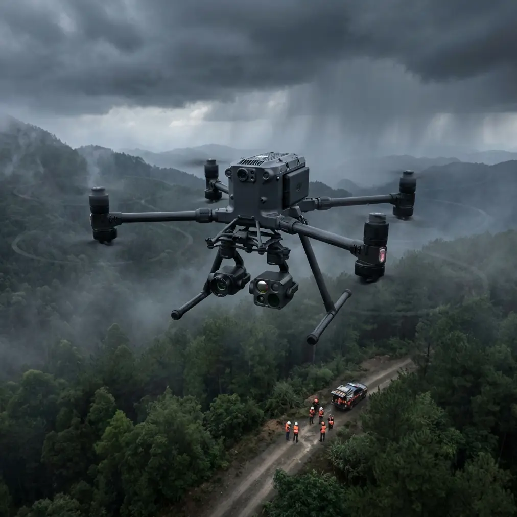
The pre-flight step many crews skip: clean the aircraft before you power up
Before checking mission files, before confirming GCP positions, before looking at wind direction, wipe down the parts of the aircraft that make safety and navigation decisions.
This is not cosmetic maintenance. It is a survey reliability step.
On a Matrice 400, especially if you are working dirt tracks, harvested fields, or dry agricultural margins, debris can collect fast. Grass seeds, fine dust, fertilizer residue, and moisture film can sit on vision sensors, lens surfaces, and other exposed components. If your aircraft uses advanced sensing to maintain stable operation and situational awareness, those surfaces need to be clean enough to do their job. In wind, small errors get amplified. A cautious aircraft reacting to partially obscured sensors can hesitate, drift off the cleanest line, or behave less predictably during low-altitude transitions.
My rule is simple: clean first, calibrate second, launch third.
Use a soft lens-safe cloth and inspect every optical surface you rely on, including payload glass. If you are collecting thermal signature data, this matters twice. Thermal imagery is unforgiving about contamination and inconsistent viewing geometry. A smudge that barely affects a visible-light image can still reduce interpretability when you are trying to spot irrigation anomalies, drainage patterns, or plant stress differences across a field block.
That one minute of cleaning protects both flight safety and downstream mapping quality.
Why horizon discipline matters more in windy surveys than most pilots think
A recent photography reference made a point that belongs in every drone survey SOP: keep the camera level. Tilted horizons and leaning buildings were described there as the first rule of composition. For field surveying, the operational significance is even broader.
In photogrammetry, a level camera is not just aesthetically cleaner. It gives your processing software a more consistent image set. In wind, the aircraft naturally works harder to maintain heading and position. If the payload operator compounds that by casually accepting off-level framing, you introduce unnecessary irregularity into the dataset. The software may still process it, but you are asking it to solve a messier geometry problem than needed.
That matters in three common field scenarios:
Orthomosaic capture over large plots
If the camera angle drifts and the visual horizon feels unstable from pass to pass, your overlap may still exist on paper, but the practical consistency of the dataset drops.Boundary verification near roads, irrigation channels, or greenhouses
Straight edges are useful references. If they begin to lean from frame to frame, interpretation becomes slower and control checking gets more tedious.Windy low-altitude missions
At lower heights, small pitch and roll disturbances affect framing more visibly. A level reference keeps the mission honest.
The photography source also highlighted the rule of thirds by dividing the frame into a 3x3 grid and placing the subject near intersection points rather than dead center. In pure mapping flights, that is not your primary composition method. But the principle still matters when you break out of grid capture and need supplemental manual shots.
For example, if you are documenting drainage failure at a corner of a field, damaged crop rows along a ditch, or erosion around access tracks, placing the feature off-center with context around it can make the image more useful for agronomists, land managers, or clients reviewing the issue later. A manual evidence shot should not feel random. It should explain.
Surveying is not only about nadir maps
A lot of Matrice 400 operators will use automated routes for photogrammetry, then manually collect supporting imagery before leaving site. That is smart. Windy fields change quickly, and some of the most useful visuals are not in the orthomosaic at all.
Here the same photography guidance becomes surprisingly relevant.
The source reference mentioned symmetry for architecture and water scenes, leading lines, framing with doors or windows, foreground elements, and negative space. None of that is “art school fluff” when adapted correctly for commercial UAV work.
Leading lines help explain field conditions
Roads, irrigation runs, fence lines, crop rows, and drainage cuts naturally pull the eye. Use them. If a client needs to understand how runoff is moving or how access routes divide a parcel, an oblique image with strong line direction communicates faster than a flat screenshot from mapping software.
Foreground adds scale
A patch of tall grass, a marker post, a pile of stones, or even a visible GCP in the near field can anchor an image. This helps the viewer read depth and terrain undulation, especially in open landscapes where scale can otherwise disappear.
Negative space improves interpretation
The original reference warned against packing the frame too full and recommended leaving space. That is excellent advice for drone field reporting. If every image is crammed with “stuff,” the viewer works harder to find the actual issue. Leave room around a failed irrigation section or stressed crop patch so the subject is obvious.
Symmetry has practical value in infrastructure at the edge of fields
If your site includes pump houses, greenhouse corridors, culverts, or water retention basins, symmetrical framing can make inspection comparisons easier across dates. It creates consistency, which is useful when you are tracking change.
These are small choices, but they compound. The Matrice 400 can carry serious imaging payloads and support advanced missions, yet the value of those payloads depends on whether the captured image actually tells the truth cleanly.
Wind changes battery planning, not just flight planning
People love to talk about endurance in abstract numbers. Field crews know better. Wind rewrites those numbers.
This is where hot-swap batteries become more than a convenience. In a windy field mission, they support continuity. You can keep the aircraft in workflow, reduce downtime, and protect mission pacing while rotating power sets efficiently. That matters when light is changing, crop canopies are shifting, and the operator is trying to maintain similar acquisition conditions across multiple parcels.
But battery speed should never lead to battery sloppiness.
During hot-swap cycles, inspect contact areas, check for dust and moisture, and confirm physical seating before committing to the next leg. The old aircraft hardware references in your source material listed a wide range of aviation fasteners and self-locking nuts, including standardized self-locking plate nuts and countersunk screw types. You do not need to become an airframe engineer to take the lesson: aircraft systems depend on secure, repeatable mechanical interfaces. On a field drone, battery attachment and payload mounting deserve that same respect. If a component is meant to lock, seat, and hold under vibration, treat it as a critical point every time.
This is especially true after transport over rough farm roads.
Transmission confidence is part of survey confidence
Open farmland often looks easy from a connectivity perspective. Sometimes it is. Sometimes it is not. Rolling ground, tree lines, utility structures, and long working distances can complicate the link. If you are operating a Matrice 400 with O3 transmission in a survey context, the key point is not just range. It is link stability under practical site conditions.
A stable transmission path helps the pilot verify framing, monitor telemetry, catch image issues early, and make live decisions if wind is stronger on one side of the property. For teams working with sensitive site data, AES-256 also matters because agricultural and industrial survey data can carry real operational sensitivity. Crop condition maps, infrastructure layouts, and thermal findings are not military secrets, but they are still business-critical information in many cases.
Secure transmission is easy to undervalue until a client asks how their survey data is protected.
GCPs still matter, even with strong onboard systems
The Matrice 400 can support sophisticated workflows, but GCP discipline still separates nice-looking maps from dependable survey outputs. In windy conditions, a few things become more important:
- Place GCPs where they remain visible and undisturbed.
- Avoid areas with crop motion or reflective standing water if those interfere with visual identification.
- Capture clean verification images of the GCP environment.
- Keep your mission height and overlap realistic rather than optimistic.
Wind often tempts operators to fly higher and faster to “get through it.” Sometimes that is sensible. Sometimes it degrades the very data you came for. If the project needs survey-grade confidence, build your mission around the conditions you actually have, not the schedule you wish you had.
Thermal work in fields needs consistency more than heroics
Thermal signature capture over fields can be useful for irrigation diagnosis, drainage assessment, and identifying uneven plant stress. But windy conditions can complicate interpretation because leaf movement, surface cooling, and mixed viewing angles all affect what the sensor sees.
That is another reason to keep your image geometry disciplined. Fly repeatable lines. Hold altitude. Avoid last-minute improvisation unless the job truly demands it. If you need oblique thermal views of a suspected issue, capture them methodically with notes, not as scattered snapshots.
The best thermal datasets are usually boring to collect. That is a compliment.
A practical windy-field workflow for the Matrice 400
Here is the sequence I recommend for teams that want fewer surprises and cleaner deliverables:
1. Start with a clean aircraft
Inspect payload lenses, vision surfaces, landing gear area, vents, and battery interfaces. Remove dust before power-up.
2. Check framing tools before takeoff
If your app supports grid overlays, use them. A 3x3 visual reference is a simple way to maintain level, balanced supplemental imagery.
3. Confirm GCP visibility
Do not assume they will “show up fine.” Review from expected altitude and angle.
4. Build a wind-aware flight plan
Increase overlap if needed. Slow down if image sharpness is trending in the wrong direction. Save margin for return legs flown into the wind.
5. Watch consistency, not just completion
A fully flown mission with mixed angles and variable image quality is not efficient. It just delays the pain until processing.
6. Use hot-swap efficiency carefully
Fast battery changes are useful, but every change is also an inspection moment.
7. Collect manual context shots before leaving
Use leading lines, foreground, and negative space intentionally. These images often explain the site better than the final map alone.
8. Secure your transfer and records
If you are working on sensitive client land, document how data was handled and transmitted. That is where systems like AES-256-backed workflows support professionalism.
If your team needs a field-ready checklist tailored to this kind of workflow, you can message us here: https://wa.me/85255379740
The real advantage of the Matrice 400 in survey work
The Matrice 400 is not valuable because it simply flies. Plenty of aircraft fly.
Its real value in surveying is that it supports a disciplined operator well. Strong transmission, secure data handling, hot-swap workflow, and advanced payload possibilities create room for better decisions in the field. But those decisions still come down to fundamentals: keep the aircraft clean, keep the camera level, plan for wind honestly, and capture images that are useful beyond the mission log.
That is the thread connecting the references behind this article. One source talked about a basic photography rule: don’t let the horizon tilt, use a 3x3 grid, and compose with purpose. Another source, though technical and hardware-focused, pointed toward the engineering mindset behind aircraft components and locking interfaces. Put those together and you get a simple truth about the Matrice 400 in real commercial work:
Reliable survey output is not built by one feature. It is built by a chain of small correct actions.
And windy fields are where that chain gets tested hardest.
Ready for your own Matrice 400? Contact our team for expert consultation.