Matrice 400 in Mountain Surveying: What Actually Matters
Matrice 400 in Mountain Surveying: What Actually Matters in the Field
META: A technical review of Matrice 400 for mountain surveying, connecting aircraft design economics, digital twin delivery, photogrammetry workflow, payload strategy, and operational efficiency.
Mountain surveying exposes every weak decision in a drone program.
On flat ground, a platform can get away with marginal workflow design, clumsy payload integration, or bloated data handling. In steep terrain, those mistakes turn into repeated flights, missed coverage, battery waste, and models that take too long to become useful. That is why the most interesting way to evaluate the Matrice 400 is not by reading a feature sheet in isolation, but by asking a harder question: how does this aircraft fit into a survey operation where flight efficiency and downstream delivery matter as much as raw flight performance?
That question becomes sharper when you look at two very different reference points.
One comes from aircraft design economics. A technical design source argues that better economic performance starts with “design to cost” thinking early in the program, not after the system is already fixed. It also makes a blunt point that still applies to modern UAV operations: reducing part count and improving connection methods often matters more to manufacturing cost than chasing weight alone. In fact, the source states that part quantity can be a better expression of tooling and manufacturing cost than weight. Another detail stands out: for machined integral structures, material utilization may be less than 20%, which means elegance in one part of the design can quietly create waste somewhere else.
The second reference comes from a digital twin delivery ecosystem. It highlights a project center with 200 full-time digital twin and 3D visualization engineers, plus cooperation with more than 30 schools and over 30 campus industry bases. That is not a drone specification. But it does reveal something more useful for Matrice 400 buyers and operators: in serious surveying work, the aircraft is only one layer in a much larger production chain. Data capture is valuable only when it feeds a scalable 3D output pipeline.
That is the right lens for judging the Matrice 400 in mountain work.
The Matrice 400 question is not “can it fly?” but “can it reduce friction?”
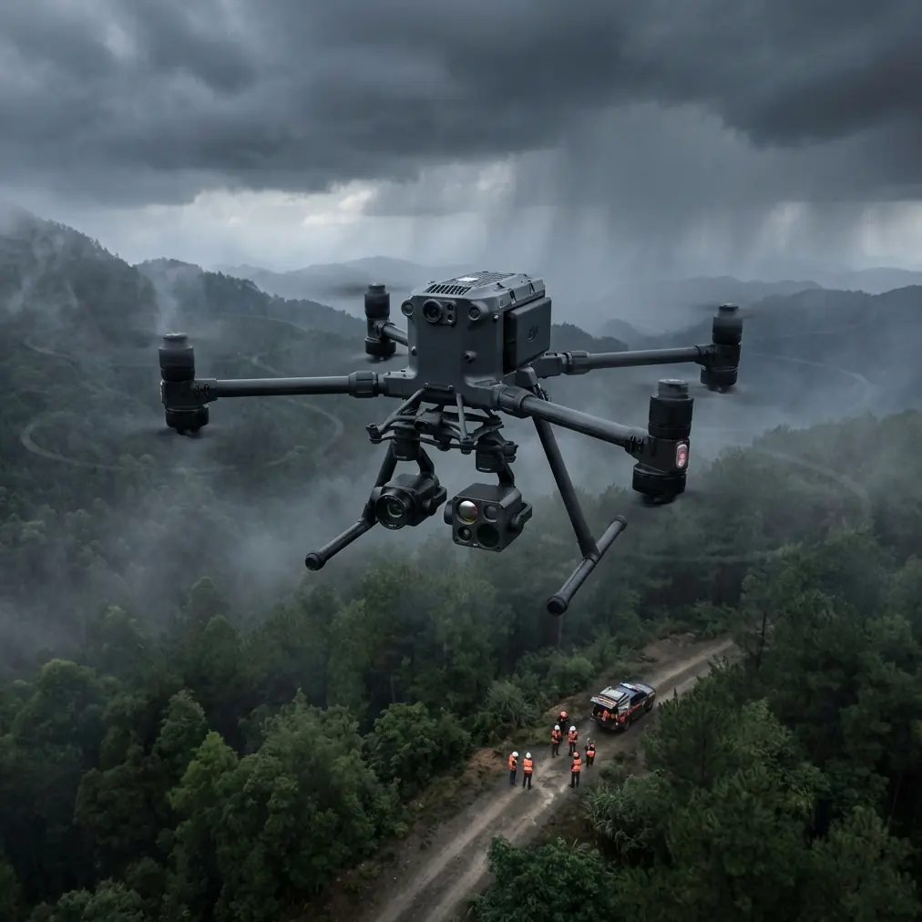
A mountain survey mission usually combines several demands at once: terrain-following flight planning, stable image geometry for photogrammetry, safe links in uneven topography, and enough operational resilience to avoid constant resets between launch sites. The Matrice 400 matters because it sits in the category where the aircraft becomes a workflow platform, not just a camera carrier.
For photogrammetry in mountain environments, that distinction is huge. Elevation changes distort overlap assumptions. Shadows alter texture quality. Narrow ridgelines create line-of-sight challenges. If your aircraft can carry the right sensing mix while preserving stable transmission and manageable field procedures, your map quality rises and your field time drops. If not, even strong pilots end up compensating manually for limitations the platform should have solved.
This is where the old aircraft-design principle from the reference becomes surprisingly current. Fewer parts and better connection methods were discussed there as drivers of technical-economic performance. In a drone context, that same principle shows up as cleaner payload integration, fewer awkward mounting transitions, less time spent reconfiguring equipment, and less chance of error at a remote mountain launch point. Operators rarely describe this in manufacturing language, but they feel it every day. Each extra interface is another failure point, another checklist item, another opportunity to waste a weather window.
A drone like the Matrice 400 is valuable when it reduces those hidden frictions.
Why mountain survey teams should care about design economics
The design handbook source goes beyond simple cost cutting. It argues for standard cost estimation, ongoing verification, and enough feedback to make corrections through design or production changes if targets are exceeded. Translate that into mountain UAV operations and you get a practical lesson: a survey team should not measure success only by aircraft uptime or flight duration. It should track the full mission economics.
That means asking:
- How many flights were needed to complete the terrain block?
- How many battery changes interrupted continuity?
- How often did payload changes force a relaunch?
- How much of the dataset passed through to modeling without rework?
- How long did it take before the client saw a usable terrain model, orthomosaic, or digital twin scene?
This is exactly where Matrice 400-type systems separate themselves. Features such as O3 transmission stability, hot-swap batteries, and encrypted links like AES-256 are often discussed as isolated upgrades. In mountain surveying, they have operational significance.
O3 transmission is not just about range on paper. In valleys and broken terrain, signal resilience affects pilot confidence, camera timing consistency, and whether the team can hold the intended collection geometry without conservative compromises. AES-256 is not there merely for compliance language. If you are mapping critical infrastructure corridors, hydropower facilities, mountain roads, or transmission routes, data security can determine whether the drone program is accepted by the client’s risk team at all. Hot-swap batteries are not a convenience feature. They help preserve mission tempo when launch conditions are difficult and daylight is tight.
Each of those details matters because it reduces downtime inside the actual survey chain.
Photogrammetry in steep terrain: where the Matrice 400 earns its keep
Mountain photogrammetry punishes lazy planning. Ground sampling distance changes with elevation. Oblique surfaces can cause thin reconstruction in cliff zones. Wind at saddle points can degrade image consistency. A capable aircraft helps, but the mission architecture matters just as much.
For Matrice 400 users, the best practice is to think in layers.
First is geometry. Terrain-aware planning should be paired with disciplined overlap targets, and in many mountain projects that means accepting that the mission will need a more conservative image density than lowland work. Second is control. GCP strategy must be realistic for slopes, vegetation, and access limits. In some mountain sites, a hybrid workflow using carefully placed GCPs plus strong onboard positioning gives a better outcome than trying to over-distribute ground control in dangerous areas. Third is sensor strategy. A visible-light photogrammetry payload may be enough for topographic modeling, but if the client also wants drainage analysis, erosion tracing, solar inspection, or vegetation stress indicators, thermal signature data can add interpretive value that conventional RGB output misses.
This is where a third-party accessory can genuinely elevate the Matrice 400 rather than just decorate it. On several mountain survey workflows, teams have improved positional consistency by adding a third-party D-RTK mounting solution or rugged field relay kit to tighten control in difficult terrain and staging areas. The accessory itself is not the story. The story is what it solves: fewer compromises in georeferencing when the terrain makes standard setups inconvenient.
That kind of enhancement fits the same logic as the aircraft design source: better connections, fewer inefficiencies, cleaner execution.
The digital twin angle is where survey value compounds
The second reference document, despite its rough formatting, contains one of the most meaningful numbers in this entire discussion: 200 full-time digital twin and 3D visualization engineers. Pair that with cooperation involving more than 30 schools and 30-plus campus industry bases, and a pattern emerges. Advanced 3D delivery is becoming industrialized. It is not a boutique post-processing step anymore.
Why does this matter for Matrice 400 operators surveying mountain sites?
Because the client increasingly expects more than a stitched map. A mining corridor, hillside development, forestry block, tourism infrastructure zone, or mountain utility route now often requires a 3D environment that can support inspection, planning, training, and stakeholder communication. The airborne collection must therefore be designed for downstream 3D use from the start.
A Matrice 400 mission planned only for a basic orthomosaic may underperform if the eventual requirement is a navigable digital twin. The operator should collect with model completeness in mind: slope-facing obliques where needed, texture coverage in shadow-prone surfaces, and enough redundancy for challenging vertical features. The payoff is not just prettier output. It is a more reusable dataset.
That is why the digital twin reference is so relevant. A delivery ecosystem with 200 specialists implies that scalable 3D production depends on standardization. The survey aircraft must feed that pipeline cleanly. If the Matrice 400 is used well, it becomes a front-end data engine for something much larger than a single map export.
BVLOS ambition needs disciplined data design, not just aircraft confidence
Many teams eye the Matrice 400 with BVLOS operations in mind, especially for mountain corridors and broad land surveys. That instinct makes sense. But BVLOS capability should not become an excuse for weak collection logic.
In mountains, long-route coverage is useful only if the returned dataset is coherent. Communication integrity, battery strategy, terrain-following accuracy, and emergency planning all matter, but the data design still comes first. If image geometry is inconsistent, or if the route ignores slope aspect and shadow timing, a BVLOS mission can return a large but mediocre dataset.
This is another place where the aircraft design handbook’s feedback principle applies cleanly. The source emphasizes cost verification and sufficient feedback to support corrective action. UAV teams should adopt the same discipline: after each mountain mission, audit not just flight metrics but model outcomes. Which legs produced weak reconstruction? Did transmission performance force deviations? Were GCPs sufficient? Did thermal payload timing align with the site’s temperature behavior? Without that feedback loop, even a strong platform gets used inefficiently.
What experienced surveyors will appreciate about Matrice 400
The best commercial drone platforms create less drama.
That sounds simple, but it is rare. A mature survey aircraft should disappear into the mission, leaving the team focused on terrain, coverage, control, and output. The Matrice 400 is most compelling when viewed through that standard. Not as a symbol of capability, but as a tool that helps a field crew maintain rhythm from setup to capture to handoff.
For mountain work, that rhythm is everything.
A crew may launch from narrow roadside shoulders, hike to temporary control points, dodge fog cycles, and coordinate with client teams who need deliverables quickly. In that environment, transmission reliability, secure handling, battery continuity, and payload flexibility have direct business value. Not abstract value. Measurable value in fewer revisits, cleaner processing, and faster movement into 3D products.
If your team is building terrain models, route alignments, volume studies, landslide documentation, or infrastructure twins in mountainous areas, the Matrice 400 should be judged by how well it supports the entire chain. The aircraft design reference reminds us that technical success and economic success are inseparable. The digital twin reference reminds us that capture quality must serve an industrial-scale visualization pipeline. Put those together, and the real standard becomes clear: the drone must help you collect once, process efficiently, and reuse the data widely.
That is the real promise of this class of platform.
Not spectacle. Not spec-sheet theater. Operational coherence.
If you are refining a mountain survey workflow around Matrice 400, especially for photogrammetry or digital twin deliverables, a practical discussion with someone who understands both airframe operations and downstream model production is often more useful than another generic comparison chart. You can start that conversation here: message a UAV workflow specialist.
Ready for your own Matrice 400? Contact our team for expert consultation.