Expert Surveying with Matrice 400: What Aircraft Design
Expert Surveying with Matrice 400: What Aircraft Design Principles Actually Mean in Urban Field Work
META: A practical expert guide to surveying urban fields with Matrice 400, connecting aircraft stability and structural design principles to safer data capture, thermal workflows, and repeatable mapping results.
Urban field surveying looks simple from the sidewalk. Lift off, run a grid, process the imagery, deliver the map. In practice, the hard part is not getting the drone in the air. It is keeping the aircraft predictable when the environment stops being clean and cooperative.
That distinction matters with a platform like the Matrice 400.
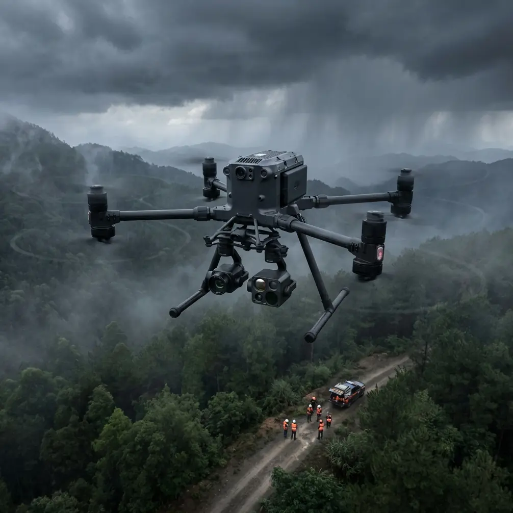
I learned this the hard way on a survey job bordered by mid-rise buildings, reflective glass, and a patchwork of open lots. The site itself was straightforward: orthomosaic, elevation model, a few thermal passes at dawn to look for drainage anomalies and heat retention around utility corridors. The problem was airflow. Between the structures, the drone kept encountering abrupt lateral disturbances. Not enough to end the mission, but enough to make every pass feel slightly different from the last. That inconsistency ripples through photogrammetry. Forward overlap can still look fine on paper while image geometry quietly degrades.
When people discuss a large enterprise aircraft, they usually jump straight to transmission range, battery systems, payload flexibility, or security features such as AES-256. Those are all relevant. But for serious urban surveying, what separates a productive aircraft from a frustrating one is often something deeper: how well its design logic handles disturbance, configuration changes, and structural demands under real operating conditions.
That is where the reference material behind this discussion becomes useful.
Why balance and controllability matter more than spec-sheet bragging rights
One of the source documents focuses on aircraft balance and handling behavior. Buried in that technical material are a few ideas that map surprisingly well to real drone surveying.
The first is the effect of sideslip on longitudinal balance characteristics. In plain terms, when an aircraft that was originally trimmed for straight, level, no-sideslip flight is forced into a steady sideslip, the pilot’s control input requirements can change in both magnitude and direction. That is not just an academic flight-dynamics point. In an urban field survey, you regularly encounter localized wind gradients, corner vortices, and reflected gusts that induce exactly the kind of off-axis disturbance that forces the flight controller to work harder.
Operationally, this matters because stable image collection depends on more than waypoint accuracy. If the aircraft repeatedly enters small sideslip states while trying to maintain track, you can see the consequences in several ways:
- camera attitude corrections become more active,
- ground sampling consistency can suffer near structures,
- overlap quality becomes less uniform,
- and thermal signature interpretation gets trickier because viewing geometry changes slightly across adjacent lines.
For Matrice 400 operators working dense sites, that means flight planning should not assume “calm enough to fly” is the same as “good enough to map.” These are not equivalent conditions.
The source text also describes a method for determining a limit sideslip angle under a specified pedal force condition. A drone pilot obviously is not stepping on rudder pedals, but the underlying lesson still applies: there is always a threshold beyond which compensation stops being elegant and starts becoming expensive in data quality. In urban surveying, your practical threshold is the point where the aircraft can still hold the route, but the imaging outcome is no longer repeatable enough for professional-grade deliverables.
With Matrice 400, the smarter workflow is to use its robust flight stability and transmission stack as a foundation, then tighten the mission around environmental reality:
- fly your photogrammetry runs during the most stable wind window, not merely the earliest available slot,
- reserve thermal work for periods when both surface contrast and aircraft stability are favorable,
- segment the mission by exposure zone if one side of the site is shielded and another sits in a wind corridor,
- and verify image geometry before committing to a full BVLOS-style extended route logic, where regulations and site conditions permit.
That last point is often missed. BVLOS is not just a range discussion. It is a confidence discussion. You need confidence in command, link quality, and aircraft behavior over the full mission envelope.
The hidden value of disturbance modeling in repeatable survey work
Another detail from the same reference is even more interesting for enterprise drone teams. The text explains that arbitrary small symmetric disturbances can be analyzed using methods such as impulse response, step response, and convolution. It also notes that larger disturbance responses may require five- or six-degree-of-freedom motion equations rather than simpler approximations.
Translated into drone operations, this is a reminder that not every wobble is equal.
Some disturbances are short and recoverable. Think of a quick lateral nudge as the aircraft crosses an alley gap between buildings. Others are persistent enough to alter the quality of an entire flight line. The difference determines whether the output remains survey-grade or drifts into “looks acceptable on screen” territory.
With a Matrice 400, this has two practical implications.
1. Treat route verification as a dynamic test, not a checkbox
Before launching a full urban field mapping mission, run a short diagnostic pattern over the most turbulent section of the site. Watch not just position hold, but gimbal correction behavior, yaw smoothness, and whether the aircraft settles cleanly after small disturbances. A platform can be technically stable while still generating suboptimal image geometry.
2. Match payload and mission mode to the disturbance profile
If you are switching between RGB photogrammetry and thermal inspection on the same site, recognize that the tolerance for motion artifacts differs. Thermal interpretation around rooftops, drainage lines, or utility trenches can be more forgiving in some respects, but it can also become more misleading if viewing angles shift enough to distort apparent heat patterns. If the mission includes GCP-supported mapping, the bar gets higher still. Once crews put down control points and commit field hours, “close enough” stops being efficient.
This is where Matrice 400’s broader enterprise architecture helps. O3-class transmission reliability, encrypted communications through AES-256, and power systems built for continuity support longer, more disciplined workflows. If the aircraft also supports hot-swap batteries in your operational setup, you reduce one of the biggest causes of rushed relaunches: the temptation to restart quickly under changed light and wind conditions just to save time. Fewer rushed restarts usually means better data continuity.
Structural design is not abstract when you fly near concrete, glass, and heat
The second source document shifts from aerodynamics to sandwich structure design and material selection. At first glance, that may seem far removed from a Matrice 400 field workflow. It is not.
Urban surveying punishes airframes in quieter ways than people realize. It is not only about collision resistance or payload lift. It is about heat, vibration, repeated transport, and the interaction between structural stiffness and sensor integrity.
The structural reference includes several details worth paying attention to.
One is the use of metal skins in the 0.3 to 1.0 mm range, with 0.3 to 0.6 mm panels being common in tail and fuselage structures. Another is the discussion of foam-core sandwich materials with common densities around 100 kg/m³ and 200 kg/m³. It also highlights that some foam systems can be formed directly inside cavities, while others cannot, and that certain laminates offer strong mechanical properties, good corrosion resistance, high impact strength, and useful electrical performance.
Why does any of this matter to an urban drone operator?
Because survey aircraft live in a world of repeated loading cycles. Cases in and out of vehicles. Fast setup on uneven pavement. Temperature swings between air-conditioned staging and sunlit rooftops. Long hovers over radiant surfaces. Occasional bumps that do not cause visible damage but still matter over time.
A well-designed structure does three jobs for a survey platform:
- it preserves sensor alignment,
- it damps or resists unwanted vibration paths,
- and it tolerates environmental stress without quietly compromising repeatability.
The material note about foam structures with use temperatures up to 120°C for certain rigid formulations is especially relevant conceptually, even if your drone should never approach those internal temperatures in normal work. Urban environments create localized heat loads that are far harsher than open agricultural terrain. Dark roofing membranes, concrete decks, mechanical plant areas, and reflected sunlight can all increase thermal stress on aircraft components and payload housings. If your mission includes thermal signature collection, this becomes doubly significant: you need the aircraft to remain mechanically and electronically stable while the sensor is trying to distinguish meaningful heat patterns on the ground.
The reference also mentions that some materials provide strong insulation and acoustic performance, with one soft foam use range reaching -30 to +80°C. Again, the practical lesson is not to obsess over the exact material system used in any one drone. The lesson is that structural and internal material choices shape how well an enterprise platform tolerates the mixed thermal and vibration environment of city work.
For Matrice 400 users, this should influence how you think about mission readiness:
- Do not evaluate the aircraft only by top-line endurance.
- Evaluate how consistently the payload behaves across repeated sorties.
- Monitor whether calibration drift appears after transport or hot weather operation.
- Pay attention to thermal data consistency after battery swaps and payload changes.
These are structural questions disguised as workflow questions.
A better urban surveying method for Matrice 400 crews
If your job is surveying fields in urban areas, here is the approach I recommend.
Start with the wind map, not the site boundary
Before you draw the flight polygon, read the surrounding structures. Buildings, retaining walls, treelines, container stacks, and even parked equipment shape the airflow. The aerodynamic reference makes it clear that off-axis disturbances affect control balance. On site, that means one section of the field may be perfect for tight photogrammetry while another section is better handled with adjusted line direction or a separate sortie.
Use GCPs where the site geometry gets visually messy
Urban edges often create weak spots for reconstruction: repetitive surfaces, shadows, reflective materials, narrow corridors. GCP placement helps anchor the model when environmental disturbances make image capture less uniform than ideal. This is especially useful near transition zones where the aircraft may encounter the strongest changes in airflow.
Separate thermal from RGB if the site is dynamically unstable
A single all-in-one mission sounds efficient. It often is not. Thermal signature work has different timing and interpretation constraints than photogrammetry. If the site is aerodynamically messy, run the thermal pass when surface contrast is strongest and the wind is still manageable, then return for RGB when the aircraft can produce the most repeatable geometry.
Build battery changes around data continuity
If your Matrice 400 workflow supports hot-swap batteries, use that advantage strategically. Do not just swap as fast as possible. Maintain heading logic, line sequence, altitude discipline, and light consistency as much as conditions allow. Battery convenience is only valuable if it protects mission coherence.
Protect the link the way you protect the airframe
In urban work, signal quality is operational quality. O3 transmission and AES-256 security are not just enterprise buzzwords. O3-class performance helps preserve command and video confidence in cluttered environments, while AES-256 matters when you are handling sensitive site imagery, utility layouts, or construction progress data that should not move casually across insecure channels.
If your team is planning a more complex deployment and wants to sanity-check the workflow before the first sortie, you can message an enterprise drone specialist here.
What changed for me after applying these principles
That difficult urban survey I mentioned earlier became manageable only after I stopped treating the aircraft as a simple camera carrier.
I broke the site into aerodynamic zones. I changed line orientation on the most exposed section. I separated thermal from RGB collection. I added a short stability verification run before the full mapping mission. And I paid more attention to how the aircraft settled after each disturbance rather than just whether it stayed nominally on route.
The result was not dramatic in the cinematic sense. No heroic recovery. No flashy moment.
Just better data.
Overlap held more consistently. The photogrammetry solution needed fewer corrective passes. Thermal anomalies around drainage paths were easier to interpret because the capture geometry was more stable. The crew spent less time arguing with the dataset in post.
That is the real value of thinking like an aircraft designer while flying a survey mission.
The aerodynamic source reminds us that aircraft response changes when disturbances, balance conditions, or mass properties change. The structural source reminds us that materials, thickness ranges such as 0.3 to 0.6 mm, and core densities like 100 kg/m³ or 200 kg/m³ are not trivia; they are part of the reason a professional aircraft can deliver repeatable results under stress. For Matrice 400 operators, those principles translate directly into sharper field decisions.
Urban surveying rewards crews who can see beyond the mission planner screen. If you understand what the aircraft is dealing with in the airframe, the control loop, and the sensor mount, you will get more from the platform—and more importantly, you will trust the data you bring home.
Ready for your own Matrice 400? Contact our team for expert consultation.