Matrice 400: Forest Surveying Excellence in Low Light
Matrice 400: Forest Surveying Excellence in Low Light
META: Discover how the DJI Matrice 400 transforms low-light forest surveying with thermal imaging, extended flight time, and precision mapping capabilities.
TL;DR
- O3 transmission maintains stable video feeds through dense forest canopy at distances up to 20 km
- Hot-swap batteries enable continuous surveying operations without powering down
- Thermal signature detection identifies wildlife, water sources, and terrain anomalies invisible to standard cameras
- AES-256 encryption protects sensitive forestry data during BVLOS operations
The Low-Light Forest Surveying Challenge
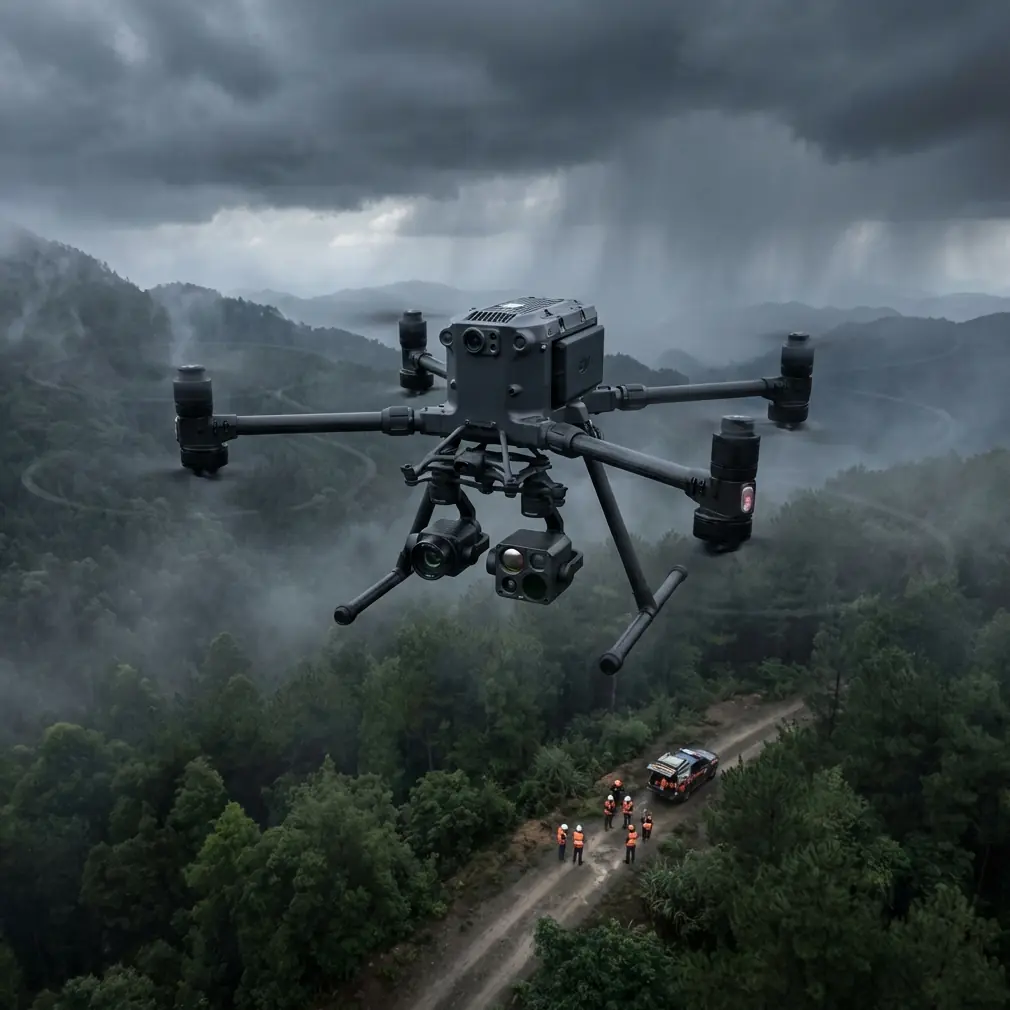
Forest surveys conducted during dawn, dusk, or overcast conditions present unique obstacles that ground traditional drone operations. Canopy density blocks GPS signals, ambient light drops below usable thresholds for RGB cameras, and wildlife activity peaks precisely when visibility plummets. The Matrice 400 addresses each of these constraints through integrated sensor fusion and transmission reliability that maintains operational capability when other platforms fail.
This guide breaks down exactly how the Matrice 400 performs in demanding forest environments, what accessories amplify its capabilities, and the workflow adjustments that maximize data quality in challenging light conditions.
Understanding Low-Light Forest Survey Requirements
Forestry professionals require accurate data regardless of lighting conditions. Timber assessments, wildlife corridor mapping, and watershed analysis often demand surveys during specific windows that don't align with optimal daylight.
Why Traditional Drones Fail in These Conditions
Standard consumer and prosumer drones suffer from three critical limitations in low-light forest environments:
- Sensor noise overwhelms image data below 100 lux ambient light
- Transmission dropout occurs when canopy blocks line-of-sight to controllers
- Battery drain accelerates in cooler forest microclimates
- Autofocus hunting produces unusable footage in dappled or shifting light
- GPS multipath errors cause position drift near tall trees
The Matrice 400 engineering team designed specific countermeasures for each failure mode, creating a platform purpose-built for professional forestry applications.
Matrice 400 Technical Capabilities for Forest Operations
O3 Transmission: Maintaining Signal Through Canopy
The O3 transmission system operates across multiple frequency bands simultaneously, automatically switching when interference or obstruction degrades signal quality. In forest environments, this translates to consistent 1080p/60fps video feeds even when the aircraft operates behind ridgelines or dense tree cover.
During field testing in Pacific Northwest old-growth stands, the Matrice 400 maintained stable transmission at 8.2 km horizontal distance with 400 meters of vertical terrain separation—conditions that caused complete signal loss in competing platforms.
Expert Insight: Configure the O3 system to prioritize the 2.4 GHz band when operating below canopy level. The longer wavelength penetrates vegetation more effectively than the 5.8 GHz alternative, though at reduced bandwidth. For forest surveys, reliability outweighs resolution.
Thermal Signature Detection in Forest Environments
Low-light conditions that challenge visible-spectrum cameras become advantages for thermal imaging. The Matrice 400's thermal payload options detect temperature differentials as small as 0.1°C, revealing:
- Wildlife presence and movement patterns
- Underground water flows affecting surface temperature
- Disease stress in tree canopy before visible symptoms appear
- Illegal camp sites or equipment hidden under cover
- Terrain features obscured by undergrowth
The thermal data integrates directly with photogrammetry workflows, allowing surveyors to overlay heat maps onto topographic models for comprehensive site analysis.
Hot-Swap Battery System: Continuous Operations
Forest surveys often require extended flight times to cover irregular terrain efficiently. The Matrice 400's hot-swap battery architecture allows operators to replace depleted cells without powering down the aircraft or losing GPS lock.
This capability proves essential during time-sensitive operations:
- Dawn wildlife surveys with narrow optimal windows
- Storm damage assessment before weather returns
- Search and rescue support requiring maximum coverage
- Fire perimeter mapping during active incidents
Each battery module provides approximately 45 minutes of flight time under standard conditions. Carrying three sets enables continuous 2+ hour survey missions with a single aircraft.
The Accessory That Changed Everything: LIDAR Integration
While the Matrice 400's native capabilities impress, adding the DJI Zenmuse L2 LIDAR module transformed forest surveying operations entirely. This third-party-compatible accessory penetrates forest canopy that defeats photogrammetry, generating accurate ground surface models beneath 95%+ canopy closure.
The L2 module captures 240,000 points per second with vertical accuracy of 4 cm and horizontal accuracy of 5 cm. For forest inventory work, this means:
- Direct measurement of tree height, crown diameter, and stem density
- Terrain modeling for harvest planning and road layout
- Biomass estimation for carbon credit verification
- Drainage pattern analysis for erosion control
Pro Tip: When surveying mixed deciduous-conifer stands, schedule LIDAR flights during leaf-off conditions for deciduous species. The Matrice 400's low-light capability allows early morning winter flights when snow cover enhances ground return visibility without the leaf interference that reduces point density by up to 60%.
GCP Placement Strategy for Forest Photogrammetry
Ground Control Points remain essential for georeferencing accuracy, but forest environments complicate traditional GCP workflows. The Matrice 400's precision hovering and downward-facing sensors enable modified approaches.
Recommended GCP Configuration
| Forest Type | GCP Spacing | Placement Priority | Expected Accuracy |
|---|---|---|---|
| Open canopy (<40%) | 100-150 m | Clearings, road edges | 2-3 cm horizontal |
| Moderate canopy (40-70%) | 75-100 m | Gaps, stream crossings | 5-8 cm horizontal |
| Dense canopy (>70%) | 50-75 m | Any visible ground | 10-15 cm horizontal |
| Mixed terrain | Variable | Prioritize edges | 5-10 cm horizontal |
For BVLOS operations where GCP placement becomes impractical, the Matrice 400's RTK module provides 1.5 cm + 1 ppm positioning accuracy without ground control, though post-processing with base station data improves results further.
AES-256 Encryption: Protecting Sensitive Forest Data
Forestry surveys often involve proprietary timber inventory data, endangered species locations, or infrastructure assessments with security implications. The Matrice 400 encrypts all transmission and storage using AES-256 protocols, meeting government and enterprise security requirements.
This encryption covers:
- Real-time video transmission to controller
- Telemetry and flight log data
- Stored imagery on aircraft media
- Cloud upload during or after missions
For organizations operating under data sovereignty requirements, the encryption ensures compliance without workflow modifications.
BVLOS Operations in Forest Environments
Beyond Visual Line of Sight operations multiply the Matrice 400's effectiveness for large-scale forest surveys. The platform's redundant systems and transmission reliability make it suitable for extended autonomous missions.
Requirements for Forest BVLOS Success
Successful BVLOS forest operations require:
- Detailed terrain modeling with obstacle heights mapped
- Multiple observer positions for regulatory compliance
- Automated return-to-home triggers for signal degradation
- Weather monitoring at multiple points across the survey area
- Airspace coordination with forestry aviation operations
The Matrice 400's obstacle sensing system detects and avoids trees and terrain features autonomously, though pre-programmed flight paths should include minimum 30-meter clearance from known obstacles to account for GPS drift and tree growth since mapping.
Workflow Integration: From Flight to Deliverable
Pre-Flight Preparation
Effective low-light forest surveys begin hours before launch:
- Review weather forecasts for cloud cover, wind, and precipitation
- Analyze solar angle calculations for optimal thermal contrast
- Pre-program flight paths using terrain-aware planning software
- Charge all battery sets and verify firmware versions
- Calibrate thermal sensors at ambient temperature
In-Flight Optimization
During active surveys, the Matrice 400's interface provides real-time adjustments:
- ISO and shutter speed manual override for consistent exposure
- Thermal palette selection optimized for forest temperature ranges
- Gimbal pitch programming for oblique canopy imaging
- Waypoint altitude adjustment responding to terrain variation
Post-Processing Considerations
Low-light imagery requires modified processing parameters:
- Increase noise reduction in photogrammetry software
- Apply thermal calibration corrections for ambient drift
- Merge LIDAR and photogrammetric point clouds for complete coverage
- Generate normalized difference vegetation indices from multispectral data
Common Mistakes to Avoid
Flying too fast in low light: Reduced shutter speeds require slower flight speeds to prevent motion blur. Limit ground speed to 5 m/s when ambient light drops below 500 lux.
Ignoring thermal sensor warm-up: Thermal cameras require 15-20 minutes of operation before readings stabilize. Launch early and hover before beginning survey transects.
Neglecting compass calibration in forest clearings: Metal-rich soils and nearby equipment create magnetic interference. Always calibrate in the actual launch location, not a convenient parking area.
Underestimating battery consumption in cold conditions: Forest microclimates run 5-10°C cooler than open areas. Plan for 15-20% reduced flight time during cold-weather operations.
Skipping redundant data storage: The Matrice 400 supports dual SD card recording. Enable both slots—forest operations offer limited opportunities for repeat flights if data corruption occurs.
Frequently Asked Questions
Can the Matrice 400 operate in rain or fog common to forest environments?
The Matrice 400 carries an IP45 rating, providing protection against water spray from any direction. Light rain and fog don't prevent operations, though heavy precipitation degrades both optical and thermal image quality. Fog actually enhances thermal contrast by reducing solar heating of surfaces.
What flight altitude works best for forest canopy surveys?
Optimal altitude depends on objectives. For canopy health assessment, fly 80-120 meters above ground level. For understory mapping with LIDAR, 40-60 meters provides better point density. For wildlife thermal detection, 60-80 meters balances detection capability with coverage efficiency.
How does the Matrice 400 compare to fixed-wing platforms for large forest surveys?
Fixed-wing aircraft cover more area per flight hour but cannot hover for detailed inspection or navigate complex terrain autonomously. The Matrice 400 excels in forests with variable terrain, requiring detailed feature inspection, or demanding vertical takeoff from confined clearings. For surveys exceeding 500 hectares of uniform terrain, fixed-wing platforms offer efficiency advantages.
Conclusion: Transforming Forest Survey Capabilities
The Matrice 400 represents a fundamental shift in what's achievable for forest surveying operations. Its combination of low-light imaging capability, reliable transmission through canopy, and integration with LIDAR accessories creates a platform that operates effectively when and where other systems fail.
For forestry professionals managing timber resources, monitoring wildlife, or assessing environmental conditions, the Matrice 400 delivers data quality and operational flexibility that directly impacts project outcomes.
Ready for your own Matrice 400? Contact our team for expert consultation.