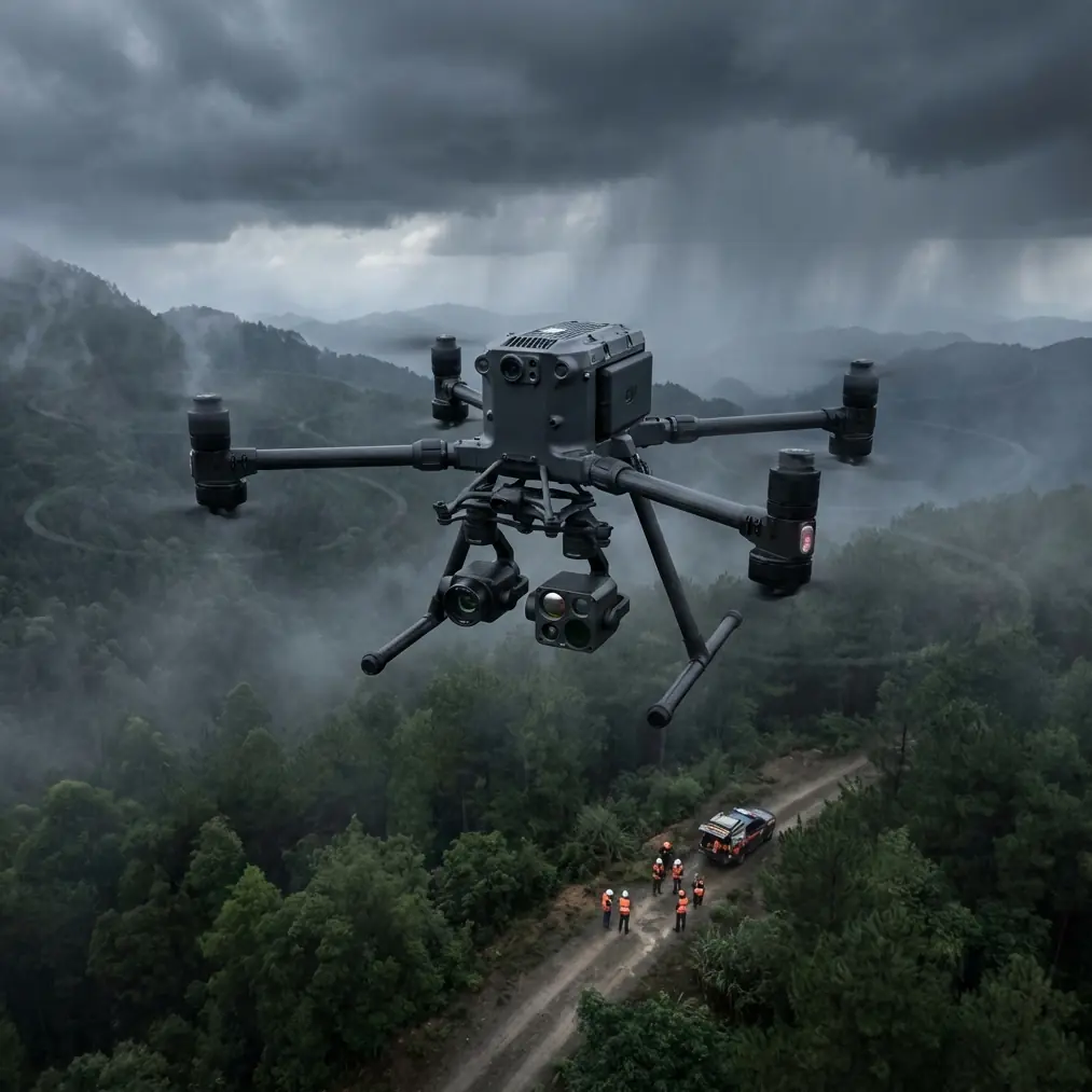
Surveying Urban Forests With the Matrice 400
Surveying Urban Forests With the Matrice 400: Field Tips That Actually Matter
META: Practical Matrice 400 tips for surveying urban forests, including thermal workflows, photogrammetry planning, battery management, O3 transmission, AES-256 security, and BVLOS-ready operations.
Urban forest surveying looks simple until you are halfway through a mission and the environment starts behaving like a patchwork of contradictions. Tree canopies block line of sight. Glass towers bounce signal. Heat leaks off rooftops and pavement, contaminating thermal interpretation. Public roads, utility corridors, playgrounds, and narrow greenbelts force tighter planning than most woodland crews expect.
That is exactly where the Matrice 400 becomes interesting.
Not because it is “powerful” in the vague marketing sense, but because urban forestry work demands a platform that can carry serious sensing payloads, hold a stable link in noisy environments, and support repeatable data capture under operational pressure. If your mission involves canopy health checks, storm damage assessment, species mapping, utility encroachment analysis, or heat-stress screening in municipal green zones, the Matrice 400 sits in a useful place: it is built for work where image quality, flight continuity, and risk control all affect the value of the final map.
This guide focuses on how to use the Matrice 400 effectively for surveying forests in urban areas. Not as a brochure. As a field workflow.
Start With the Survey Objective, Not the Aircraft
The biggest planning mistake I see is pilots selecting flight parameters before deciding what the client actually needs to measure.
Urban forest jobs usually fall into four buckets:
Photogrammetry for structure and canopy coverage
This is the right choice when you need orthomosaics, 3D surface models, crown spread estimates, tree inventory context, and change detection over time.Thermal signature analysis
Useful for spotting irrigation anomalies, stressed vegetation, moisture differences, early decay indicators, or heat interactions between trees and adjacent built surfaces.Mixed visible and thermal documentation
Often the best route for city planners, arborists, and environmental consultants who need one map for geometry and another layer for interpretation.Inspection-style missions
These are tighter, more selective flights for looking at individual trees near roads, buildings, substations, or telecom infrastructure.
The Matrice 400 matters here because it supports the kind of payload flexibility and mission reliability that urban forestry work punishes if you get wrong. You do not want to discover halfway through a corridor run that your thermal pass should have been flown at a different altitude, or that your mapping overlap is unusable under broken canopy shade.
Use O3 Transmission as an Operational Tool, Not a Spec Sheet Detail
In urban forest environments, transmission quality is not just about convenience. It affects decision-making in real time.
The presence of O3 transmission is operationally significant because city-edge forest surveys often run through cluttered RF environments. You may be flying near apartment blocks, schools, roadside infrastructure, power lines, and municipal facilities that create interference or visual blockage. A stronger, more stable transmission system gives the pilot and payload operator better live awareness when framing oblique passes, checking thermal contrast, or verifying overlap at the site rather than back in the office.
That matters most in two situations:
- Canopy edge mapping near structures where a weak downlink can make it harder to verify whether the facade-tree boundary is captured cleanly.
- Linear urban green corridor flights where brief signal instability can disrupt confidence during route execution, especially if the mission extends beyond ideal visual alignment.
If your operations are progressing toward BVLOS workflows where regulations and approvals allow, robust link performance stops being a nice extra and becomes part of your risk case. Even for VLOS missions, O3 gives you more confidence when terrain, canopy, and urban geometry combine to obscure orientation.
The point is simple: if you are surveying a municipal forest parcel bordered by buildings, the transmission system directly affects data confidence and mission continuity.
Protect the Data Before You Fly It
Urban forestry projects increasingly involve sensitive locations. School grounds. Government property. Corporate campuses. Utility rights-of-way. Private estates. Ecological restoration zones with restricted access.
That is where AES-256 deserves more attention than it usually gets.
Many teams talk endlessly about sensors and almost never about data protection. That is backwards. If you are collecting high-resolution imagery and thermal data over mixed public-private landscapes, encrypted transmission and secure handling are not admin details. They are part of professional field practice.
AES-256 has practical value in at least three ways:
- It supports more secure live data transmission during sensitive operations.
- It reduces risk exposure when working around critical infrastructure or regulated sites.
- It strengthens trust with municipal and enterprise clients who increasingly ask how airborne data is protected in transit.
For urban forest contractors, that can be the difference between being treated like a hobby operator with a nice aircraft and being treated like a serious survey partner.
Photogrammetry in Urban Forests: Plan for Shadows, Not Just Overlap
A Matrice 400 can capture excellent mapping data, but urban tree environments punish lazy mission design.
The usual overlap targets are only the beginning. In city forests and green corridors, your biggest threats are:
- moving shadow lines from tall buildings
- reflective surfaces nearby
- repeated canopy textures
- narrow access corridors
- uneven terrain under dense crowns
This is where GCPs still earn their keep.
Yes, modern workflows can do impressive things with onboard positioning and refined processing, but if your deliverable is going to be used for management decisions, boundary comparisons, drainage planning, or tree-by-tree remediation, good ground control remains one of the simplest ways to improve confidence. In urban settings, GCPs are especially valuable because the environment often creates inconsistent visual references. Pavement edges, parked vehicles, fencing, and shade patterns can complicate tie point quality.
My practical recommendation: do not distribute GCPs only around the perimeter. In urban forest parcels, place them so they support the interior geometry of the site wherever access allows. A nice-looking orthomosaic is not the same thing as a dependable one.
For canopy modeling, I also recommend capturing at least one supplemental flight pattern beyond the standard nadir grid when the site includes tall, isolated trees or abrupt canopy-to-building transitions. Obliques can rescue detail that nadir-only missions often flatten.
Thermal Signature Work Requires Timing Discipline
Thermal surveys in urban forests can be incredibly revealing, but they are also easy to misread.
A tree crown does not exist thermally in isolation. It is influenced by roof heat, asphalt, retained wall warmth, water runoff, shaded lawns, HVAC exhaust, and adjacent façade reflection. If you are using the Matrice 400 for thermal signature analysis, timing matters as much as payload selection.
Three rules from field practice:
Avoid peak thermal chaos unless the goal is heat interaction mapping.
Midday can generate strong false contrasts around hardscape and buildings.Fly repeatably if comparing health trends.
Different solar loading conditions can produce different conclusions from the same stand.Pair thermal with visible data every time.
A thermal anomaly without spatial and visual context is often just an invitation to over-interpret.
Operationally, the Matrice 400 platform helps because it is suited to carrying serious sensing systems while maintaining stable mission control. But that only pays off if the operator respects thermal discipline. I have seen crews collect beautiful thermal footage that was nearly useless because every hot patch from a nearby parking lot bled into the interpretation of tree stress.
If your site includes urban heat islands, schedule the mission with the surrounding surfaces in mind, not only the vegetation.
The Battery Tip That Saves More Missions Than Any Camera Setting
Let’s talk about the field habit that actually prevents bad data days: battery management.
On long urban forest jobs, the temptation is to squeeze one more line out of a battery set, especially when access is awkward and the client is watching. Resist it.
With hot-swap batteries, the Matrice 400 gives crews a major practical advantage. The real value is not simply faster turnaround. It is preservation of mission continuity. On a multipart forestry survey, especially one broken into sectors around roads or buildings, hot-swapping lets you maintain workflow discipline without rushing preflight checks or forcing the aircraft into a hard break between segments.
My field tip is this: swap earlier than your instincts tell you to, and do it on your own schedule, not the battery’s schedule.
Here is why that matters in urban forestry:
- Returning with a larger reserve gives you more buffer for unexpected reroutes around people, vehicles, or temporary airspace complications.
- It reduces the chance of ending a flight with partial overlap on the final mapping lines.
- It keeps battery temperature behavior more consistent across the day, which helps with predictable planning.
A simple rule I teach crews is to identify the “point of no elegance” for each site. That is the battery threshold where the mission stops being smooth and starts becoming reactive. On some sites that happens well before the legal or technical minimum because the route home crosses obstacles, streets, or denser canopy. Once you know that threshold, land before it.
Hot-swap capability makes that discipline easier to maintain. Use it.
If you want to compare mission planning ideas with another operator before flying a tricky urban parcel, send over your scenario here: message us on WhatsApp.
Build a Two-Pass Workflow Instead of Forcing One Flight To Do Everything
A common Matrice 400 mistake in urban forest surveying is trying to collect mapping-grade visible data and decision-grade thermal data in one compromise flight.
You usually get one of two outcomes: the thermal altitude is wrong for interpretation, or the visible mission is inefficient for photogrammetry.
A better workflow is often:
- Pass one: visible-light photogrammetry for orthomosaic and 3D structure
- Pass two: thermal mission tuned for the diagnostic goal
This separation gives you cleaner inputs and a more defensible final output. The Matrice 400 is well suited to this because it is intended for professional mission cycles, not casual one-battery improvisation.
For municipal clients, this two-pass approach also helps during reporting. Decision-makers understand layered evidence better when the geometry and thermal interpretation are derived from clearly defined capture methods.
Urban BVLOS Readiness Is About Procedure, Not Ambition
A lot of operators throw around the term BVLOS as if it automatically means advanced capability. In reality, urban forest BVLOS work is mostly about structure: route design, risk assessment, communication procedures, emergency planning, observer logic where required, and confidence in your aircraft link and data controls.
That is where the Matrice 400’s combination of transmission capability, secure communications, and mission-focused battery workflow becomes strategically useful. It supports the kind of operational maturity BVLOS-oriented teams need to build, even if today’s mission remains within visual line of sight.
If you are not approved for BVLOS, the lesson still applies. Fly like you are building toward a more formal operation. That means consistent checklists, repeatable mission templates, stronger documentation, and tighter battery discipline.
Urban forest contracts tend to get more complex over time, not less. The teams that prepare early are usually the ones who keep the work.
A Practical Mission Blueprint for an Urban Forest Parcel
If I were sending a Matrice 400 crew to survey an urban woodland bordered by roads and mid-rise buildings, the workflow would look something like this:
- Conduct a site walk focused on launch recovery zones, pedestrian activity, canopy gaps, and RF obstacles.
- Set GCPs where they support both perimeter and interior model stability.
- Run a visible-light mapping mission first while shadows are manageable and consistent.
- Review coverage on site before changing payload or mission profile.
- Fly the thermal pass at a time matched to the diagnostic objective, not merely the crew schedule.
- Swap batteries conservatively using a pre-planned rotation, especially if the day is warm or the site forces longer returns.
- Log anomalies immediately, including reflective surfaces, irrigation zones, heat-retaining structures, and tree groups with unusual canopy response.
That is not glamorous. It is what produces usable outputs.
Why the Matrice 400 Fits This Work
The Matrice 400 makes sense for urban forest surveying because the job is less about raw flying performance and more about mission resilience. You need stable transmission in cluttered environments. You need secure data handling when flying over sensitive sites. You need battery procedures that support segmented survey work. And you need enough platform confidence to collect visible and thermal datasets without turning every sortie into a compromise.
That is why details like O3 transmission, AES-256, hot-swap batteries, and disciplined GCP use matter. They are not scattered features. In urban forestry, they connect directly to output quality, operational safety, and client trust.
If your survey goal is serious enough to influence management decisions, species planning, maintenance budgets, or public safety work, those details stop being optional.
They become the job.
Ready for your own Matrice 400? Contact our team for expert consultation.