Matrice 400 for Urban Forest Surveys: What a 5,380
Matrice 400 for Urban Forest Surveys: What a 5,380-Meter Heavy-Lift Record Really Tells Us
META: Expert tutorial on using Matrice 400 for urban forest surveying, with lessons drawn from a 5,380-meter heavy-lift drone record, payload resilience, flight stability, and practical mission planning.
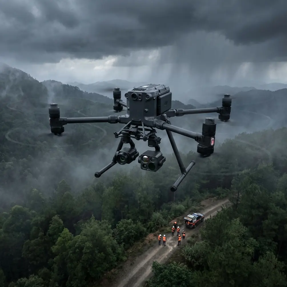
Urban forest surveying looks easy on paper. Trees are stationary. The work is civilian. The mission profile seems straightforward: map canopy cover, inspect tree health, detect stress, and document risk along roads, parks, campuses, and utility corridors.
Then reality intervenes.
Tree canopies interfere with visibility. Urban electromagnetic clutter can affect signal quality. Temperature gradients distort thermal reads. And payload decisions matter more than many teams expect, especially when a single sortie may need to combine RGB photogrammetry, thermal signature analysis, and precise repeatable positioning tied to GCP workflows.
That is exactly why the most useful way to think about the Matrice 400 is not as “just another enterprise drone,” but as an aircraft whose value becomes clearer when you study what separates serious aerial platforms from lighter-duty systems.
A recent report from CAAC News offers a revealing benchmark. In Tibet, at an elevation of 5,380 meters, Xi’an Tianyi Technology Group’s JDY-100B heavy-lift UAV completed a suspended-load flight test in air density estimated at only 60% of sea-level conditions. During the test, the aircraft held a 30-kilogram load in a stable hover, flew for 15 minutes, and landed accurately. The platform itself has a maximum takeoff weight of 221 kilograms and a stated payload capacity of 100 kilograms. The flight reportedly set a new record for multirotor transport capability in plateau conditions.
That aircraft is not the Matrice 400. But the lesson absolutely applies to Matrice 400 buyers and operators.
When a multirotor proves it can maintain control authority, lift stability, and precision landing in thin air with meaningful suspended mass, it highlights the engineering variables that matter in every demanding civilian mission: power margin, propulsion efficiency, flight control tuning, structural confidence, and payload discipline. Those same variables determine whether an urban forestry team gets clean data on the first pass or spends the day reflying sections of a canopy corridor.
Why a high-altitude heavy-lift test matters to Matrice 400 users
Most urban forest operators will never survey at 5,380 meters. Many will work near sea level or moderate elevations. Some may assume that a Tibetan plateau test has little relevance to a city arborist, environmental consultant, or campus facilities team.
That would be a mistake.
High-altitude testing compresses the truth. It exposes weaknesses fast.
At 5,380 meters, with air density around 60% of what you get on the plains, rotor systems lose aerodynamic support. Every control correction costs more. Payload margin shrinks. Hover behavior becomes a real measure of design quality, not a marketing spec. If a drone can suspend a 30-kilogram load stably for 15 minutes in that environment and still execute a precise touchdown, it demonstrates what robust multirotor engineering looks like under stress.
For Matrice 400 operations in urban forests, the translation is practical:
- Stable lift margin matters when flying with a mixed sensor stack.
- Precision control matters when working around tree lines, roads, fences, and buildings.
- Payload confidence matters when switching between photogrammetry and thermal missions.
- Accurate landing matters when operating from constrained launch areas such as park roads, service yards, or compact clearings.
In other words, extreme-condition performance in the wider UAV sector tells us what to respect when evaluating a platform like the Matrice 400 for municipal and environmental work.
Urban forest surveys are really payload-management missions
Surveying forests in urban environments is rarely a one-sensor job.
A planning team may need:
- RGB imagery for canopy modeling and photogrammetry
- Thermal signature data to identify stress patterns, irrigation anomalies, or heat-retaining hardscape influences
- Repeatable geospatial control tied to GCP checkpoints
- Secure data handling for environmental or infrastructure-adjacent sites
- Reliable transmission in signal-complicated city environments
This is where the Matrice 400 enters the conversation as a serious work platform rather than a consumer-adjacent drone stretched into enterprise use.
Compared with lighter competitors, the Matrice 400 category tends to appeal to teams that care less about minimum kit weight and more about operational consistency. That distinction matters. A lighter drone may look attractive in a brochure, but once you add enterprise optics, thermal needs, repeat missions, urban interference, and the expectation of clean deliverables, smaller platforms often begin to show their limits in endurance, transmission resilience, or workflow flexibility.
The CAAC-reported heavy-lift record reinforces the broader point: multirotor success is built on margin. Not barely enough power. Not barely enough stability. Margin.
That is exactly what urban forestry projects consume.
The feature set that matters most in city-canopy work
Let’s move from the benchmark lesson to the Matrice 400 workflow itself.
1. Sensor flexibility is only useful if the aircraft stays composed
Forest survey teams often obsess over camera choice, and that is understandable. Photogrammetry outputs rise or fall on image quality, overlap discipline, and geometry. Thermal signature interpretation depends on timing, emissivity awareness, and scene context.
But no sensor can fix unstable flight behavior.
When you are flying over irregular canopy height in a city park, the aircraft is constantly managing micro-adjustments. Wind rolls over treetops differently than it does over open pavement. Warm rooftops create localized thermal turbulence. Courtyard launches can produce awkward initial climbs.
A more capable aircraft platform gives your payload a better working environment. That means cleaner image sets, fewer motion-compromised frames, and more confidence in downstream processing.
The 5,380-meter record is useful here because it reminds us that control stability is not abstract. In thin air, with 30 kilograms slung underneath, any weakness would have been obvious. For Matrice 400 operators, the takeaway is simpler: if your mission depends on high-quality mapping and repeatability, prioritize aircraft composure over headline gadgetry.
2. O3 transmission is not a luxury in urban forestry
Urban forests are rarely isolated forests. They sit beside apartment blocks, schools, substations, highways, sports facilities, and office parks. Wireless congestion is part of the operating environment.
That is why O3 transmission capability matters. In practical terms, robust transmission helps maintain clear live view, dependable telemetry, and more confident positioning during route execution. In city-edge canopy work, that means fewer interruptions when the aircraft crosses near structures or transitions between open corridors and tree-dense sections.
Competitors may promise range, but urban forest work is less about theoretical distance and more about signal integrity in cluttered real-world environments. A platform that keeps command and video links dependable when the backdrop gets messy gives crews a meaningful operational edge.
This becomes even more important as organizations plan for more advanced workflows, including carefully authorized BVLOS programs where local rules and operational approvals allow them. Even if a mission remains visual line of sight, the discipline required for future-scaled operations starts with transmission confidence today.
3. AES-256 matters for environmental and municipal contracts
Forestry data is not always “sensitive” in the dramatic sense, but it can still be operationally protected. Municipal tree inventories, infrastructure-adjacent corridor imagery, campus landscape condition records, and environmental consulting datasets often sit inside controlled client workflows.
AES-256 support matters because it helps organizations align aerial operations with internal security expectations. This is one area where professional buyers should be less casual than hobby-driven reviewers. If your team is collecting recurring site intelligence, even for benign civilian uses such as canopy health, storm recovery planning, or invasive species monitoring, secure data transmission and handling are part of the platform decision.
It is not the most glamorous feature. It is one of the most professional.
4. Hot-swap batteries change field productivity more than spec sheets suggest
Urban forestry missions often involve segmented flying: one block of street trees, then a park edge, then a retention basin, then a campus perimeter. The bottleneck is frequently not total workday flight time but turnaround time between flights.
Hot-swap batteries reduce dead time. That matters if you are trying to preserve consistent lighting conditions for RGB mapping or stay inside a narrow morning thermal window before solar loading changes the interpretive value of your imagery.
This is where Matrice 400-style enterprise workflow design tends to outperform lighter competitors. On paper, many drones seem “fast enough.” In the field, repeated battery interruptions, reboot delays, and awkward payload resets chew through productivity. A hot-swap-capable operation can keep crews moving and maintain survey rhythm, which often improves final dataset consistency.
How I would deploy a Matrice 400 for urban forest surveying
If I were building a repeatable city-canopy workflow around the Matrice 400, I would structure it in five steps.
Step 1: Split the mission by deliverable, not by convenience
Do not try to collect every dataset in one improvised flight style. Separate your objectives:
- Photogrammetry for canopy surface and tree inventory geometry
- Thermal signature collection for stress indicators
- Targeted visual inspection for limbs, crown asymmetry, or infrastructure conflicts
This avoids compromising image overlap, altitude discipline, and capture timing.
Step 2: Build GCP discipline into the project from the start
Urban forest maps often need to align with planning layers, utility references, or municipal GIS systems. GCP use remains one of the best ways to improve confidence in final outputs, especially where tree canopy can obscure ground features and automated reconstruction has fewer clean tie points.
A good airframe helps, but accurate mapping still depends on field methodology. Matrice 400 gives you a stronger platform for repeatable collection. GCP practice turns that into defensible survey products.
Step 3: Use thermal only when the timing is defensible
Thermal data gathered at the wrong hour creates noise disguised as insight. For tree health work, timing should account for sun angle, surface heating, recent weather, irrigation cycles, and species behavior. The aircraft’s job is to deliver stable, controlled collection. Your job is to ensure the thermal story is real.
Step 4: Respect urban launch and recovery constraints
Precise landing is underrated in forestry work. Unlike broad agricultural fields, urban green spaces often offer limited takeoff and landing zones. A drone that recovers accurately reduces risk to equipment and improves turnaround speed between batteries and payload tasks.
The CAAC report specifically mentioned a precise landing after a 15-minute flight carrying a 30-kilogram suspended load at 5,380 meters. Again, not the same aircraft, but the operational lesson is universal: precision recovery is a core performance metric, not a footnote.
Step 5: Plan for signal complexity, not ideal conditions
Survey teams should rehearse around line-of-sight interruptions, tree-edge transitions, and surrounding RF clutter. O3 transmission strength is valuable, but it works best inside a disciplined operating plan. Predefine antenna setup, observer positions, battery swap points, and emergency contingencies.
What competitors often get wrong
A lot of competing platforms are sold around simplicity, portability, or headline imaging specs. Those points are not meaningless. But for urban forest surveying, they can distract from what actually determines mission success.
The best aircraft for this work is not necessarily the smallest one or the one with the most exciting brochure image. It is the one that keeps your data collection stable, your turnaround efficient, your transmission reliable, and your security posture aligned with professional requirements.
That is where Matrice 400 stands out.
It fits teams that want a platform built for repeated operational use, not occasional demonstration flights. And when viewed through the lens of the JDY-100B’s plateau record, the distinction becomes sharper. The UAV industry’s toughest tests always reward the same things: power reserve, control stability, and disciplined engineering. Urban forest surveys may be less dramatic than a 5,380-meter heavy-lift milestone, but they reward the same fundamentals.
A practical final thought for serious operators
The most revealing detail in the CAAC report may not even be the record itself. It may be the effort behind it: a four-person team traveled 11,078 kilometers from Xi’an to a remote test point in Nagqu’s Amdo County, including passage through a 600-kilometer uninhabited zone, just to validate performance in the right environment.
That level of field commitment is a useful reminder. Professional UAV work is not about trusting assumptions. It is about testing where conditions are demanding enough to expose the truth.
If you are evaluating the Matrice 400 for urban forest surveying, do the same in your own context. Test with the actual sensor package. Test around dense canopies. Test battery swaps under time pressure. Test thermal workflows inside narrow morning windows. Test transmission near the structures you will actually work around.
If you want to discuss configuration choices or compare payload strategy for a forestry workflow, you can message the team here: chat about your Matrice 400 survey setup.
The operators who get the best results from a platform like Matrice 400 are usually the ones who understand that aircraft performance is not a spec-sheet debate. It is a field reliability question. And the field always tells the truth.
Ready for your own Matrice 400? Contact our team for expert consultation.