Matrice 400 in Coastal Forest Surveying: What Flight
Matrice 400 in Coastal Forest Surveying: What Flight-Control Redundancy and Installation Discipline Really Mean in the Field
META: Expert case-study analysis of Matrice 400 for coastal forest surveying, with practical insight on flight altitude, redundancy logic, turbulence handling, payload reliability, and safe sensor installation.
Coastal forest surveying looks simple on a map. In the air, it is not. Salt-heavy moisture, unstable sea-breeze transitions, gusts rising over canopy edges, and uneven light under maritime cloud all turn an ordinary mapping sortie into a test of aircraft discipline. That is why the most useful way to think about the Matrice 400 is not as a spec sheet item, but as a system that either keeps working gracefully when conditions deteriorate, or forces the crew to break the mission into smaller and less efficient pieces.
For this scenario—surveying forests along a coast—the most revealing reference point is not a drone brochure at all. It comes from civil aircraft design practice: redundant control laws that can automatically reconfigure after failures, and installation rules that treat spacing, vibration, heat, and contamination as operational concerns rather than workshop trivia. Those ideas matter directly to how a Matrice 400 should be configured, flown, and maintained when you are trying to capture survey-grade photogrammetry and thermal signature data over tree cover near the sea.
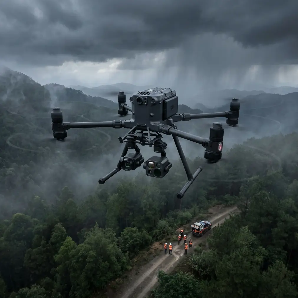
A field case: mapping a wind-exposed coastal forest block
Picture a forestry team tasked with documenting canopy density, storm damage corridors, and drainage changes across a coastal woodland belt. The area includes pine stands near dune systems, lower wetland margins, and sections of salt-stressed vegetation where thermal anomalies may reveal disease or root-zone stress before RGB imagery does. The mission combines photogrammetry, selected thermal passes, and a set of GCPs placed where canopy openings permit clean visual identification.
This is exactly the kind of job where crews are tempted to focus on the obvious variables: overlap, shutter interval, sun angle, and whether the link will hold at the far edge of the parcel. Those matter. But the harder-earned lesson is that mission consistency depends just as much on how the aircraft handles disturbance and how its subsystems are physically arranged.
The reference material on civil flight-control systems describes a layered structure: normal control law (NL), alternate control law (AL), and direct control law (DL), with automatic reconfiguration when faults appear. It also notes that changes in control mode should be indicated to the operator. On a large industrial UAV platform such as the Matrice 400, the operational significance is straightforward: resilience is not only about avoiding total failure. It is about preserving predictable handling long enough to complete or safely terminate a mission when a sensor, power path, or controller input degrades.
For coastal forest work, that matters more than many teams realize. Gust fronts at canopy boundaries create brief attitude disturbances that may not end a flight, but can degrade image geometry, reduce overlap consistency, or trigger pilot overcorrection. A platform designed around layered control behavior stands a better chance of maintaining usable tracking and calmer aircraft response, especially during long linear legs where the aircraft crosses from open shoreline exposure into rougher air above uneven tree crowns.
Why control-law thinking matters for Matrice 400 users
The reference source describes A- and B-type law combinations constructed around different flight phases and modes. While that language comes from manned aircraft design, the principle transfers well to enterprise UAV operations: the aircraft should not behave as though takeoff, transit, low-altitude survey lines, and return are all the same job. Each phase places different demands on stabilization, operator workload, and energy management.
In coastal forest surveying, the Matrice 400 will usually face four distinct phases:
- Departure from a constrained launch point, often a sand track or maintenance clearing with crosswind exposure.
- Transit to the work area, where O3 transmission reliability and link management become more relevant than camera cadence.
- Low-to-mid altitude mapping lines, where attitude stability governs photogrammetry quality.
- Return and landing, often with changing battery state and shifting sea breeze.
The reference discussion of automatic reconfiguration from NL to AL or DL is significant because it frames a truth every serious survey operator should accept: continuity under fault is part of data quality. If control response changes abruptly and opaquely, even a recoverable event can ruin a block by introducing inconsistent forward motion, yaw deviation, or altitude excursions across several lines. If the platform is engineered to manage degradation in a structured way, the mission stands a better chance of ending with salvageable data rather than a total remobilization.
Just as important is the mention of a mechanical backup law for pitch and yaw in the civil-aircraft example. No one should force a one-to-one analogy onto a UAV, but the design philosophy is valuable: preserve a path to controllability even when higher-level automation is compromised. For Matrice 400 operators flying BVLOS-oriented workflows or large-area coastal blocks, that philosophy should shape pre-mission risk planning. The question is not “Can the aircraft fly this route in ideal conditions?” The better question is “If one layer of stabilization or sensing becomes unreliable, do we still have enough controllability and telemetry confidence to protect the aircraft and the data?”
The overlooked clue in the source: load alleviation
One of the most useful details in the source material is the description of load alleviation control law (LAL), intended to reduce structural loads at the wing root and suppress vertical gust loads. The text explicitly ties this to improved dispatchability even under a single fault condition.
That is not abstract aeronautical theory. It points directly to a field reality in coastal woodland work: vertical disturbances are common. As sea air crosses tree lines, embankments, and warmer inland patches, you often get rolling uplift and short downward punches. Even if a multirotor is not a winged aircraft, the operational lesson remains highly relevant. The less violently the aircraft has to respond to turbulence, the better your mapping geometry, the lower your vibration burden on payloads, and the lower your cumulative stress on mounts, cables, and connectors.
For the Matrice 400, this means crews should care about more than whether the aircraft can “hold position.” They should evaluate whether the aircraft-payload combination remains calm enough to preserve image sharpness and thermal consistency in disturbed air. Thermal work over forests is especially unforgiving. A wobble that might be acceptable in simple visual inspection can blur temperature boundaries in canopy crowns and reduce confidence in anomaly interpretation.
Optimal flight altitude for this scenario
For coastal forest surveying with the Matrice 400, my preferred starting point is 80 to 110 meters above canopy, then adjust based on canopy uniformity, wind shear, and the ground sample distance required by the client.
Why that band? Below about 80 meters above canopy in a coastal forest, the aircraft is more exposed to the mechanical turbulence generated by treetops, gaps, and edge effects. That tends to show up as small but meaningful attitude corrections that hurt image consistency. Above roughly 110 meters, you usually gain smoother air, but you may begin trading away the level of crown detail needed for tree-health interpretation, drainage feature extraction, or precise stock assessment—unless your payload and lens selection compensate.
For photogrammetry, I usually advise choosing the lowest altitude that still gives you calm-enough air for repeatable line quality. In these environments, that often means resisting the urge to fly too low. A beautifully sharp single image at 60 meters is less valuable than a complete, geometrically clean block at 95 meters with stable overlap and fewer yaw deviations. If thermal signature capture is part of the mission, the slightly higher and smoother altitude often produces more consistent pass-to-pass data because the aircraft is not constantly fighting canopy-generated turbulence.
GCP placement remains essential if deliverables require stronger absolute accuracy. In coastal forest blocks, distribute GCPs where you can maintain visibility in openings without biasing all control toward access roads or bare sand. The Matrice 400 can cover large areas efficiently, but no aircraft solves poor ground control design.
Reliability starts before takeoff: installation discipline
The second source document looks at equipment installation, spacing, shielding, and maintainability. This may seem far removed from UAV fieldwork until you start losing time to intermittent faults, vibration-induced connector wear, or heat-related sensor oddities.
Several details deserve attention.
The document states that moving mechanical parts and structures should be separated by 15 mm, with a minimum of 6 mm, and that designs should prevent misconnection where rods or tubes could be wrongly linked and affect structure or systems. That principle is gold for enterprise drone operations. On a Matrice 400 configured for repeated field deployment, accessory routing, payload mounting, cable retention, and quick-change hardware should never be treated casually. Coastal work adds vibration, moisture, and frequent setup cycles. A connector or cable that “just clears” in the workshop may rub under real flight loads, especially after repeated folding, transport, and battery changes.
Another reference detail is the requirement that equipment capable of producing sparks or ignition sources be kept at least 300 mm from oxygen lines in civil aircraft, or otherwise protected by shielding. The specific oxygen-system context does not directly map to a drone, but the underlying lesson absolutely does: high-energy components and sensitive lines should be physically segregated where possible, and where distance is limited, shielding and protection are not optional. For Matrice 400 field payloads, that translates into cleaner cable planning around power distribution, sensor interfaces, telemetry modules, and battery bays.
The same source also notes that equipment mounted on shock absorbers should maintain clearance from fixed parts, with not less than 5 mm in one cited condition. Again, the precise numbers come from aircraft installation practice, but the operational takeaway is universal. If you are running a survey payload on a large UAV in rough coastal conditions, vibration isolation only works as intended when the surrounding installation envelope respects movement under load. If brackets, housings, or wires crowd the mount, the system may still power on and pass a bench test while quietly degrading data quality in flight.
What this means for a Matrice 400 survey workflow
When I help teams optimize this class of mission, I push them to build the workflow around three layers.
1. Stable data capture over raw speed
The Matrice 400’s value in forest survey is not merely that it can cover ground. It is that it can hold a disciplined path while carrying the right payload mix for RGB, thermal signature work, and broader site documentation. Use O3 transmission and AES-256-secured workflows as operational infrastructure, not marketing terms. Strong link integrity and protected data handling matter when sorties are long and blocks are remote.
2. Battery strategy that protects consistency
Hot-swap batteries are not only a convenience. In humid coastal sites, fast turnarounds reduce the risk of ad hoc field improvisation. If your crew can rotate power quickly without disturbing payload alignment or rushing relaunch checks, they are more likely to maintain the same altitude logic, overlap settings, and block continuity across sorties.
3. Installation quality as a repeatability issue
Every remounted payload, every routed cable, every landing on uneven ground affects the next dataset. Survey crews who treat mounting clearances, shielding, and vibration control with the seriousness found in manned-aircraft reliability practice usually produce cleaner outputs with fewer mystery artifacts.
If your team is trying to define the right Matrice 400 configuration for coastal forestry, it helps to discuss the mission as a system problem rather than a camera problem. You can reach me for that kind of planning through this direct field workflow contact.
A practical mission profile
For a real coastal forest block, I would structure the Matrice 400 operation this way:
- Launch from the most open inland edge available rather than the immediate shoreline when possible.
- Begin mapping at around 90 meters above canopy as a baseline.
- Watch aircraft attitude behavior during the first two lines, not just image exposure.
- If canopy-edge turbulence is visible in telemetry or in the aircraft’s correction pattern, climb in small increments before changing overlap strategy.
- Capture photogrammetry during the most stable light window, then run targeted thermal passes once the thermal objective is clearly defined.
- Use GCPs to anchor the model where canopy openings permit unambiguous identification.
- Inspect payload mounts, battery seating, cable runs, and moving clearances after every transport leg, not only at day start.
That last point is where the reference material becomes surprisingly practical. The difference between a clean survey day and a frustrating one is often hidden in installation discipline. A few millimeters of unmanaged cable movement or a mount working too close to a fixed bracket can create vibration, intermittent behavior, or subtle image degradation that operators mistakenly blame on wind alone.
The bigger takeaway
The Matrice 400 makes the most sense in coastal forest surveying when you view it through an aviation-grade reliability lens. The source material highlights two ideas worth carrying straight into UAV practice.
First, automatic reconfiguration of control behavior under fault is valuable because it preserves manageable aircraft response when the mission environment is already unstable. For coastal forest blocks, that directly supports safer operations and better data continuity.
Second, installation spacing, shielding, and maintainability rules are not paperwork culture. They are the quiet engineering habits that keep payloads trustworthy in vibration, moisture, and repeated field deployment.
Those are the details that separate a drone flight from a survey operation.
Ready for your own Matrice 400? Contact our team for expert consultation.