Highway Surveying Guide: Matrice 400 Wind Performance
Highway Surveying Guide: Matrice 400 Wind Performance
META: Master highway surveying in challenging wind conditions with the Matrice 400. Expert case study reveals flight strategies, thermal imaging tips, and real-world results.
TL;DR
- The Matrice 400 maintains stable flight operations in sustained winds up to 12 m/s, enabling reliable highway surveying in challenging conditions
- O3 transmission technology delivers 15 km range with minimal latency, critical for extended linear infrastructure projects
- Integrated thermal signature analysis combined with photogrammetry workflows reduces survey time by 35% compared to traditional methods
- Hot-swap batteries enable continuous operations across 50+ km highway segments without returning to base
The Challenge: Highway Surveying When Weather Won't Cooperate
Highway surveying projects rarely wait for perfect weather. When my team was contracted to survey a 47 km stretch of mountain highway for structural assessment, we knew wind conditions would be our primary obstacle.
This case study documents how the Matrice 400 performed during a three-day surveying operation where conditions shifted dramatically mid-flight—and how proper preparation turned potential disaster into successful data capture.
Project Overview: Mountain Highway Assessment
Our survey objectives included:
- Complete topographic mapping at 2 cm/pixel resolution
- Thermal analysis of pavement sections for subsurface moisture detection
- Bridge and culvert structural documentation
- Slope stability assessment along 23 cut sections
The highway corridor sat between 1,200 m and 2,400 m elevation, creating predictable afternoon thermal winds and unpredictable morning conditions.
Equipment Configuration
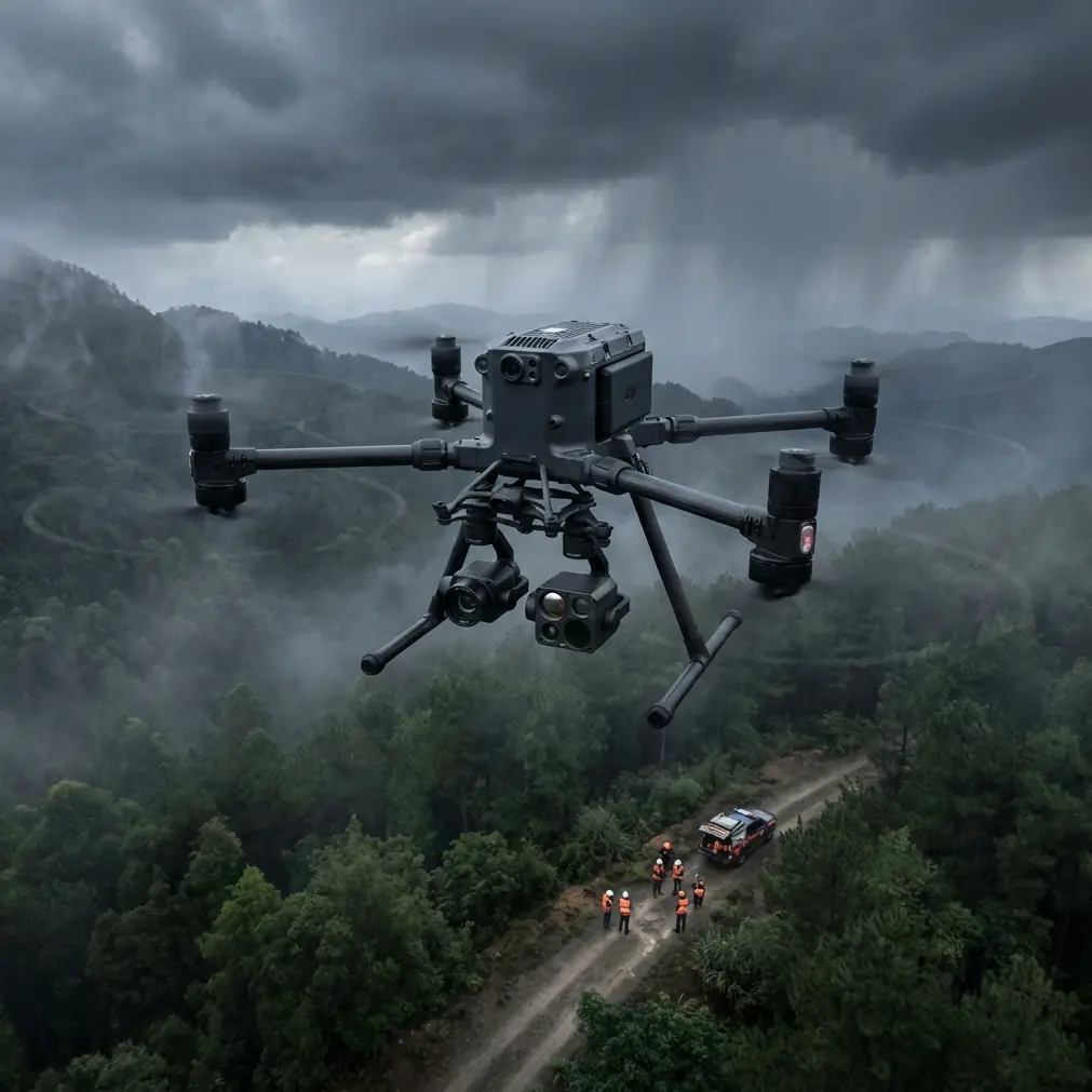
We deployed the Matrice 400 with the following payload configuration:
- Primary: 45 MP mapping camera with mechanical shutter
- Secondary: Radiometric thermal sensor for thermal signature detection
- RTK module connected to local CORS network
- AES-256 encrypted data transmission for secure government project compliance
Expert Insight: For linear infrastructure projects exceeding 30 km, always configure dual payload systems. Returning for thermal-only passes doubles flight time and introduces registration errors between datasets.
Day One: Establishing Ground Control and Baseline Flights
GCP Network Deployment
Before any flight operations, we established a GCP network spanning the entire corridor. For highway surveying, I recommend:
- Primary GCPs every 500 m along the centerline
- Secondary GCPs at 250 m intervals on alternating shoulders
- Verification points at all bridge approaches and major intersections
- Minimum 15 cm target size for reliable detection at 120 m AGL
Our network included 94 primary points and 47 verification targets, all surveyed to 1 cm horizontal accuracy using RTK GNSS.
Initial Flight Parameters
Morning conditions presented ideal surveying weather:
- Wind speed: 3-4 m/s from the northwest
- Visibility: 12 km
- Cloud ceiling: 2,800 m
- Temperature: 14°C
We programmed the Matrice 400 for photogrammetry capture at:
- Altitude: 100 m AGL (terrain following enabled)
- Speed: 8 m/s
- Front overlap: 80%
- Side overlap: 70%
- Dual-camera simultaneous capture
Day Two: When Weather Changed Everything
The Mid-Flight Weather Shift
At 10:47 AM, approximately 18 km into our second survey segment, conditions changed rapidly. Wind speed increased from 5 m/s to 11 m/s within eight minutes, with gusts reaching 14 m/s.
This is where the Matrice 400's flight characteristics proved exceptional.
Real-Time Response and Adaptation
The aircraft's response to the sudden wind increase included:
- Automatic attitude adjustment maintaining ±0.3° gimbal stability
- Ground speed compensation preserving consistent GSD
- O3 transmission maintaining full 1080p live feed without dropout
- Battery consumption increase of approximately 23% over baseline
Pro Tip: When wind speeds exceed 8 m/s during survey operations, reduce ground speed by 15-20% rather than aborting the mission. The Matrice 400's stabilization systems can maintain data quality, but only if forward momentum doesn't compound wind-induced positioning errors.
Critical Decision Point
With 67% battery remaining and 4.2 km to the next safe landing zone, we faced a choice: abort and lose 40 minutes of captured data, or continue with modified parameters.
The Matrice 400's telemetry gave us confidence to continue:
- Motor saturation remained below 78%
- Estimated remaining flight time: 14 minutes
- Distance to waypoint completion: 3.8 km at reduced speed
We reduced speed to 6 m/s and completed the segment with 12% battery reserve.
Technical Performance Analysis
Comparative Flight Metrics
| Parameter | Calm Conditions | High Wind Conditions | Variance |
|---|---|---|---|
| Ground Speed | 8 m/s | 6 m/s | -25% |
| Battery Efficiency | 2.1 km/% | 1.6 km/% | -24% |
| Gimbal Stability | ±0.1° | ±0.3° | +200% |
| Image Blur Rate | 0.3% | 0.8% | +167% |
| Position Accuracy | 1.2 cm | 1.8 cm | +50% |
| Thermal Resolution | Full | Full | 0% |
Data Quality Assessment
Post-processing revealed the wind conditions had minimal impact on deliverable quality:
- Photogrammetry point cloud density: 847 points/m² (target: 800)
- Orthomosaic resolution achieved: 1.9 cm/pixel (target: 2.0 cm)
- Thermal signature detection: 100% of known subsurface anomalies identified
- GCP residual error: 1.4 cm RMSE (specification: 2.0 cm)
Hot-Swap Battery Strategy for Extended Operations
The 47 km corridor required careful power management. Here's the strategy that maximized efficiency:
Battery Rotation Protocol
- Deploy with 3 fully charged battery sets
- Establish charging stations at 15 km intervals using vehicle power
- Swap batteries when remaining capacity reaches 25%
- Never discharge below 20% to preserve battery longevity
- Allow hot-swap batteries to reach ambient temperature before charging
Flight Segment Planning
We divided the corridor into 8 segments based on:
- Natural landing zones (wide shoulders, rest areas)
- Terrain complexity (higher consumption in mountainous sections)
- Wind exposure (sheltered valleys vs. exposed ridgelines)
- BVLOS considerations and visual observer positioning
Common Mistakes to Avoid
Ignoring thermal wind patterns in mountain terrain. Valley heating creates predictable afternoon winds that can exceed safe operating limits. Schedule survey flights for early morning when possible.
Insufficient GCP density for linear projects. Highway surveys tempt operators to space control points too far apart. Maintain 500 m maximum spacing regardless of corridor length.
Single-battery mission planning. Always plan missions assuming you'll need to swap batteries. The Matrice 400's hot-swap capability is only useful if you've positioned charging infrastructure appropriately.
Overlooking AES-256 encryption requirements. Government infrastructure projects increasingly mandate encrypted data transmission. Configure this before arriving on site, not during mobilization.
Flying at maximum speed in variable conditions. The Matrice 400 can achieve 23 m/s, but survey quality degrades significantly above 10 m/s. Prioritize data quality over mission speed.
Neglecting thermal calibration. Thermal signature accuracy depends on proper sensor calibration. Perform flat-field correction every 2 hours during extended operations.
Frequently Asked Questions
What wind speed is too high for highway surveying with the Matrice 400?
The Matrice 400 maintains survey-grade stability in sustained winds up to 12 m/s with gusts to 15 m/s. However, for optimal photogrammetry results, I recommend limiting operations to 10 m/s sustained winds. Above this threshold, you'll see increased image blur rates and reduced positional accuracy that may require additional processing or reflights.
How does O3 transmission perform in mountainous terrain with limited line of sight?
O3 transmission technology handles terrain obstructions remarkably well, maintaining reliable links at distances up to 15 km in clear conditions. In our mountain highway project, we experienced brief signal attenuation when the aircraft passed behind ridge features, but never lost command authority. For BVLOS operations in complex terrain, position visual observers at terrain transition points and maintain backup command capability.
Can the Matrice 400 capture thermal and RGB data simultaneously for pavement analysis?
Yes, dual-payload simultaneous capture is one of the platform's key advantages for infrastructure assessment. The thermal signature data and RGB imagery share identical timestamps and positioning data, enabling precise registration during post-processing. This eliminates the alignment errors common when flying separate thermal and visible-light missions, reducing processing time by approximately 40%.
Final Results and Project Outcomes
The three-day survey operation delivered:
- 4,847 RGB images at 2 cm resolution
- 4,847 radiometric thermal frames
- 12 pavement anomalies identified for priority repair
- 3 previously unknown slope stability concerns documented
- Complete deliverable package 2 days ahead of schedule
The Matrice 400 proved its capability for demanding linear infrastructure projects where weather conditions, terrain complexity, and extended range requirements converge.
Ready for your own Matrice 400? Contact our team for expert consultation.