Matrice 400 for Highway Surveying in Complex Terrain
Matrice 400 for Highway Surveying in Complex Terrain: A Technical Review from the Field
META: A technical review of how Matrice 400 fits highway surveying in difficult terrain, with analysis of multi-angle data capture, remote-area operations, weather resilience, and workflow impact.
Highway surveying looks straightforward on paper. In practice, it rarely is.
A proposed corridor can cut across ridgelines, drainage channels, retaining slopes, half-finished interchanges, and long stretches with weak site access. The survey problem is not just distance. It is geometry, visibility, and consistency under changing field conditions. That is why the most useful signal in DJI’s January 8, 2025 announcement about the Matrice 4 Series was not a flashy spec sheet. It was the framing: tools built for daily aerial operations, designed to gather data from multiple angles, and intended for roads less traveled.
For teams evaluating the Matrice 400 for highway work, that language matters more than it first appears.
The reason is simple. Corridor mapping in complex terrain is won or lost by repeatable information capture, not by a single impressive flight. A highway survey platform has to perform when the access road turns to mud, when the slope face needs an oblique pass rather than a top-down one, and when weather shifts halfway through a mission. If the Matrice 400 is being considered for this role, the right way to assess it is through operational logic: how well it supports photogrammetry, thermal review when needed, long linear missions, and field continuity under less-than-ideal conditions.
Why the Matrice 4 Series announcement is relevant to Matrice 400 buyers
DJI described the Matrice 4 Series as a new line of aerial tools for operational tasks rather than occasional showcase flights. That distinction aligns closely with highway surveying. Road projects are not one-off media captures. They are repetitive, schedule-driven missions that require consistent overlap, dependable links, and the ability to revisit the same corridor after rain, excavation, blasting, slope stabilization, or paving.
The announcement also highlighted multi-angle data collection. For a highway team, that is not a marketing flourish. It has direct consequences for deliverable quality.
A nadir-only flight can document carriageway width and broad terrain shape well enough in open ground. It struggles when the corridor includes cut slopes, bridge abutments, roadside drainage, barriers, stacked retaining structures, and embankments obscured by terrain breaks. Multi-angle capture improves surface reconstruction on vertical or near-vertical features and reduces the blind zones that often force expensive rework. In practical terms, that means fewer return visits to recover missing geometry around structures that matter most to design and maintenance decisions.
The phrase “roads less traveled” is equally significant. Highway surveying often happens before a road is fully accessible, or in segments where there is no service road at all. A platform that is conceptually aimed at hard-to-reach and lightly traveled areas is a better fit for greenfield route planning, mountain expressway work, and post-weather assessment along remote sections of corridor.
What this means for a Matrice 400 workflow
The Matrice 400 should be judged less as a standalone aircraft and more as a corridor-survey system. In that role, several capabilities become central: stable transmission, secure data handling, efficient battery management, payload flexibility, and enough mission continuity to keep the survey moving when conditions deteriorate.
For a highway corridor, O3 transmission is not just a convenience feature. In broken terrain, signal quality is operational. A long linear flight can move behind terrain undulations, roadside structures, and tree cover surprisingly quickly. Robust transmission helps maintain command confidence and live situational awareness, especially when the route bends through uneven topography. For teams planning beyond visual line of sight where local rules and approvals allow, transmission integrity becomes even more consequential. BVLOS corridor work demands disciplined procedures, but the platform’s link reliability is one of the foundations that makes such operations viable in the first place.
AES-256 matters for a different reason. Survey data often seems harmless until you consider what it can reveal: route alignments, critical infrastructure details, work progress, temporary access points, and construction sequencing. On transport projects involving public agencies, utilities, and major contractors, secure handling of imagery and telemetry is not optional. Strong encryption supports chain-of-custody discipline and reduces risk when data moves from field capture into processing and client review environments.
Then there is power management. Hot-swap batteries sound mundane until you run corridor missions for a living. They reduce downtime between sorties and preserve field rhythm. On a highway job, the real cost of battery replacement is not the swap itself. It is the loss of lighting continuity, crew focus, and carefully staged ground control timing. Hot-swapping helps teams keep aircraft, pilot, visual observers, and ground survey crew synchronized. That translates into more usable flying windows, especially in mountainous regions where wind and cloud can compress the day.
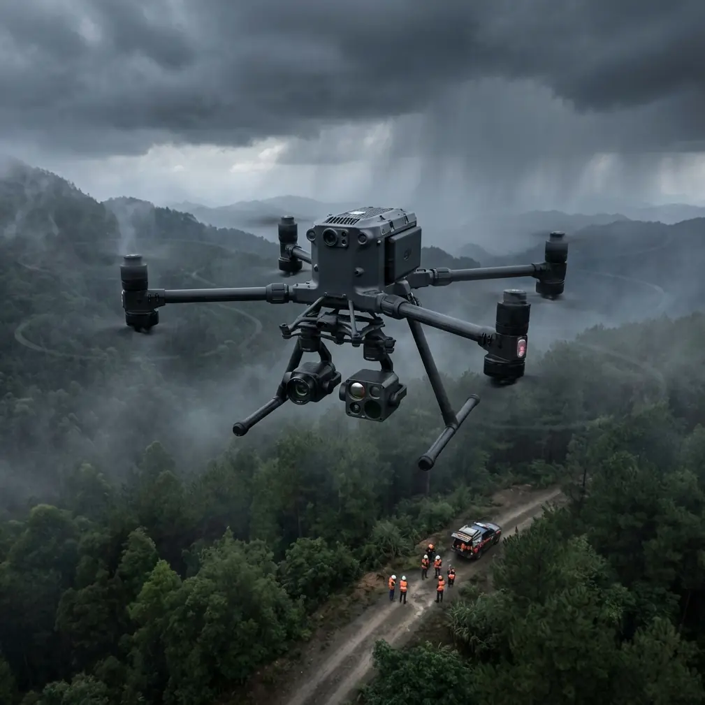
A field scenario: weather changes mid-flight
Consider a common case: a highway survey across hilly ground with mixed cut-and-fill sections. The morning begins with stable visibility and enough light for a standard photogrammetry mission tied to GCPs placed at key control points along the alignment. The plan is to capture nadir imagery first, then run angled passes along the steeper embankments and retaining features.
Halfway through the second segment, weather shifts.
A crosswind develops through the valley. Low cloud starts building over one ridge. Light changes fast, and the surface contrast on compacted earth and rock faces becomes uneven. This is where a corridor aircraft stops being a brochure and starts being either useful or expensive.
In that situation, the core value of a Matrice-oriented operational design is composure under transition. Multi-angle capture becomes more than a preferred option; it becomes the recovery mechanism for a corridor that no longer presents ideal photogrammetry conditions from directly overhead. Oblique passes can preserve detail on slope faces and drainage edges that flatten out under poor top-down contrast. A stable transmission link helps the pilot maintain confidence as terrain and weather begin to interact. Hot-swap capability reduces pressure to overextend a battery cycle in marginal air. If thermal signature review is part of the mission set, perhaps to check water intrusion, drainage anomalies, or pavement heat inconsistency in adjacent developed sections, the aircraft’s ability to continue structured data collection rather than retreat into ad hoc flying makes a difference.
That is the quiet dividing line between a drone that looks capable and one that supports an actual survey program.
Why multi-angle collection is operationally significant
DJI’s explicit emphasis on data from multiple angles deserves more attention than it usually gets.
Highway survey teams often think first in terms of area coverage, overlap percentages, and GSD. Those are necessary, but in complex terrain they are incomplete. A road corridor is full of surfaces that do not face the sky: headwalls, culvert entries, noise barriers, piers, guardrail lines, rock cuts, and steep ditches. If those surfaces are poorly captured, the model may still look acceptable in overview while hiding the exact defects that affect design verification or maintenance planning.
Multi-angle acquisition improves reconstruction fidelity on these problem surfaces. It supports better photogrammetric tie points around irregular geometry and helps reduce voids where shadowing or occlusion would otherwise degrade the model. For highway asset inspection, this can mean cleaner linework extraction around drainage structures and more trustworthy measurements on slope stabilization elements. For progress monitoring, it means fewer false assumptions caused by incomplete geometry in the digital twin.
This is one place where the Matrice 4 Series messaging directly informs a Matrice 400 buying decision. If your use case is highway work in uneven terrain, the platform should not merely tolerate angled capture. It should make that mode productive.
Reliability is not a headline feature, but it is the one that keeps jobs on schedule
The reference documents supplied alongside the DJI news include material from aircraft design manuals on reliability, maintainability, and material behavior. They are not product-specific, but they reinforce a point experienced operators already know: aerospace usefulness is cumulative. Reliability is built from many small design choices that reduce failure, simplify service, and preserve performance under stress.
One document references reliability test and verification tables, including values such as 1.5377 and 1.6254 in the extracted data. Those numbers, by themselves, do not define anything about the Matrice 400. Their significance here is conceptual. Serious aviation thinking measures confidence statistically, through validation and repeatability, not through anecdotes. For a highway surveying team, that translates into a practical standard: the aircraft must be dependable enough that mission planning can be based on expected performance rather than hope.
The materials document adds another useful perspective. It describes stainless steel processing and corrosion resistance, including heat-treatment ranges such as 1050 to 1100C and notes on good weldability and corrosion behavior. Again, this does not tell us the Matrice 400’s bill of materials. What it does highlight is the importance of durability logic in aircraft systems exposed to harsh environments. Highway work brings dust, moisture, temperature swings, and repeated transport between sites. Any platform selected for routine corridor missions should be assessed with that lens: not just how it flies when new, but how well its structure, connectors, payload interfaces, and maintenance flow support repeated field deployment.
That is the kind of scrutiny specialists should bring to a Matrice 400 review.
Mapping discipline still matters more than aircraft branding
Even a highly capable platform will not rescue a weak survey plan.
If the mission is intended for engineering-grade corridor outputs, GCP strategy remains critical. In complex highway terrain, control should be distributed to reflect vertical variation, not just linear distance. Ground points clustered along accessible roadside shoulders often leave the model weak on elevated or recessed features. A better approach is to place control where it improves geometric stability across terrain breaks and structure transitions.
The same applies to flight design. Nadir passes may be efficient, but they should be paired with oblique collections where slopes, structures, or vegetation shadowing justify it. Thermal signature collection, if part of the workflow, should be timed to the actual diagnostic objective rather than added as an afterthought. Drainage detection after rainfall, moisture differentiation in embankments, and pavement heat behavior each have their own timing logic.
This is where the Matrice 400’s value will ultimately be judged. Not by abstract capability, but by whether it integrates smoothly into disciplined field methods.
The right question to ask about Matrice 400
The wrong question is whether the Matrice 400 is powerful.
The right question is whether it reduces uncertainty across a highway survey lifecycle.
Can it collect the corridor in a way that captures difficult geometry from more than one perspective? The Matrice 4 Series announcement strongly suggests DJI sees that as central to modern aerial operations. Can it support work in remote or lightly accessed areas? That same announcement explicitly points in that direction. Can it stay productive when weather changes and the mission has to adapt instead of stop? That is where transmission stability, secure data handling, sensible battery workflow, and disciplined mission planning all converge.
For teams building out a transport survey program, that is the standard worth using.
If you are comparing workflows for mountain roads, expressway widening, or remote alignment verification, it helps to discuss the mission architecture before choosing the payload and sortie pattern. You can share your corridor scenario directly through this field coordination channel: https://wa.me/85255379740
The Matrice 400 belongs in this conversation because highway surveying is not simply about flying farther or carrying more. It is about gathering trustworthy information under field conditions that rarely stay tidy. DJI’s January 2025 framing around daily operations, multi-angle data capture, and support for less-traveled areas lands squarely in that reality. For highway teams, those are not soft themes. They are the bones of a workable survey system.
Ready for your own Matrice 400? Contact our team for expert consultation.