Matrice 400 for Highway Survey Work: What One Wheat
Matrice 400 for Highway Survey Work: What One Wheat-Field Drone Story Reveals About Reliable Operations in Heat, Dust, and Long Corridors
META: A technical review of Matrice 400 for highway surveying in extreme temperatures, using real-world agricultural drone workflow and aircraft reliability principles to explain safer, cleaner, more dependable field operations.
Highway surveying sounds nothing like crop protection on paper. Different payloads. Different deliverables. Different clients. Yet one recent field report from Xinjiang offers a surprisingly useful lens for understanding how a Matrice 400 should be prepared and operated when the job involves long road corridors, punishing temperatures, dust exposure, and little tolerance for downtime.
The report is simple: in Tagedasiman Village, Xianbai Bazar Town, Yutian County, a professional plant-protection team treated more than 300 acres of wheat during a critical growth stage. Before the drones lifted off, the crew did four things in sequence: they mixed the chemical to agricultural standards, checked the aircraft, planned the route, and set the spray parameters. Then the drones flew stable, orderly passes and delivered an even application across the field to control aphids and other common pests.
That sequence matters far beyond agriculture.
For Matrice 400 highway survey missions, especially in extreme heat or cold, the strongest operators are rarely the ones who obsess over brochure features first. They are the ones who build discipline into pre-flight preparation. The agricultural case shows an operational truth that maps directly to corridor surveying: consistency starts before takeoff.
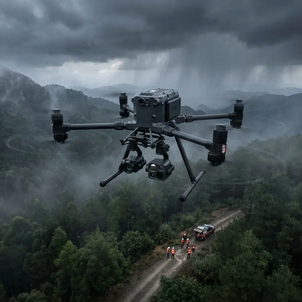
Why this matters for Matrice 400 highway work
A highway survey mission is unforgiving in its own way. You may be collecting photogrammetry data across many kilometers, tying the model to GCPs, validating thermal signature anomalies on pavement edges or retaining structures, and maintaining stable transmission while working near moving traffic corridors, overpasses, and reflective surfaces. If temperatures swing hard, every weak point in the workflow gets exposed.
That is why the pre-flight routine deserves more attention than most teams give it.
In the wheat example, the route and application settings were not improvised in the air. They were planned on the ground. For a Matrice 400 survey crew, the equivalent is mission design around overlap, altitude, speed, terrain following, payload behavior, RTK status, GCP layout, and expected transmission interruptions. The lesson is not “copy agriculture.” The lesson is that mission quality depends on parameter discipline.
Aerial mapping failures are often blamed on wind, heat shimmer, GNSS conditions, or payload limitations. Those are real constraints. But many avoidable problems begin with something more basic: dirty sensors, contaminated landing gear contact points, clogged vents, loose connectors, residue near battery interfaces, or a rushed pre-flight because the crew wants to beat the sun.
The overlooked safety habit: pre-flight cleaning
If I were building a field SOP for Matrice 400 highway operations, I would make pre-flight cleaning a non-negotiable step, not a cosmetic one.
The reference material on aircraft backup systems and system isolation points to a design philosophy that is highly relevant here: keep systems simple, reliable, and isolated so a fault in one area does not spread into another. In crewed aviation, that principle is tied to emergency backup flight control design, where the goal is safe return and landing even after a primary system failure. One extracted principle says the backup system should be as simple and reliable as possible, with high MTBF. Another emphasizes structural separation so faults in the main control mode do not propagate into the backup path.
For a Matrice 400 operator, that philosophy translates into maintenance behavior. You do not have to redesign the aircraft to benefit from the concept. You apply it in the field by preventing contamination and hidden faults from spreading across the aircraft.
Before a highway survey in dusty summer conditions, I would clean and inspect:
- Vision and obstacle sensing windows
- Thermal and RGB payload glass
- Battery bay contacts and surrounding surfaces
- Cooling inlets and exhaust paths
- Landing gear joints and exposed mechanical interfaces
- Antenna surfaces and mounting points
- Gimbal damping area
- External ports and protective covers
This is not housecleaning. It is fault isolation by habit.
Dust around a battery interface can contribute to intermittent power seating issues. Smears on optical sensors can reduce obstacle-awareness confidence or distort image quality. Fine road grit near cooling paths can raise thermal stress during prolonged mapping runs. Residue on payload glass can compromise thermal interpretation, which matters if the mission includes thermal signature review for drainage problems, heat retention differences, or surface distress screening.
The agricultural team checked equipment status before flight because bad preparation wastes product and risks crop health. A highway survey crew should think the same way: a dirty aircraft doesn’t just produce ugly data; it can undermine reliability over an entire corridor mission.
Stable passes still win jobs
Another detail from the wheat operation deserves attention. The report emphasizes that the drones moved smoothly in organized patterns and produced uniform coverage over the crop canopy. In agriculture, the objective was even spray deposition. In highway surveying, the analog is even data geometry.
That means repeatable flight lines, stable speed, predictable image intervals, and camera behavior that supports clean reconstruction. If your Matrice 400 is flying a long highway corridor, stable passes are what turn raw captures into usable photogrammetry. They also reduce the downstream pain of inconsistent sidelap, mismatched exposure behavior, and unnecessary reflights.
Operators often focus on payload specs but overlook the fact that corridor mapping quality is a rhythm problem. The aircraft has to hold its plan. That becomes harder in extreme temperatures because battery performance, wind patterns above heated road surfaces, and local convection can all interfere with consistency.
This is where hot-swap batteries become operationally meaningful. Not because “hot-swap” sounds advanced, but because highway jobs are long and interruptions matter. If you can rotate power quickly without dragging out the turnaround, you preserve the continuity of your capture plan. That reduces the chance of lighting changes and traffic-condition shifts creating visual inconsistency between mission segments.
Extreme temperature operations are really systems-management exercises
People tend to discuss extreme temperatures as if they are only a battery problem. They are not.
Heat affects crew pace, tablet readability, connector handling, sensor temperature equilibrium, and even how carefully checks are performed. Cold changes setup dexterity, battery conditioning discipline, and startup timing. In both cases, the mission becomes a systems-management exercise.
The aircraft handbook excerpts in your references come from crewed aviation, but their logic is useful here. One pressure-test standard requires leak checks for at least 2 minutes, using immersion or soap-water bubble observation under defined pressure conditions. That may sound far removed from a Matrice 400, yet the underlying engineering culture is exactly right for industrial UAV work: inspect methodically, test under realistic conditions, reject what shows signs of leakage or hidden defect, and don’t confuse “probably fine” with airworthy-enough-for-mission.
For highway survey crews, that mindset shows up in smaller ways:
- Do not skip seal and cover inspections after transport in dust.
- Verify battery seating and latch engagement every cycle.
- Confirm payload mounting integrity after long vehicle transits over rough roads.
- Check that cooling paths are unobstructed before launching into high ambient temperatures.
- Validate data link quality before committing to a full corridor leg.
This is also where O3 transmission and AES-256 become practical, not decorative, talking points. On a highway project, the data link is carrying command reliability and often sensitive infrastructure imagery. Strong transmission performance helps with long, linear survey geometry where sightlines can change. AES-256 matters because road and infrastructure datasets are often controlled by internal security requirements even when the project itself is entirely civilian.
If your team is planning long-corridor operations and needs a field workflow review, I usually recommend starting with mission hygiene rather than hardware shopping; a quick way to discuss that is message our technical desk on WhatsApp.
BVLOS changes the standard of preparation
When a highway survey extends into BVLOS planning frameworks where regulations and approvals permit, the tolerance for sloppy setup drops again.
This is where the backup-control principle from the reference material becomes especially relevant. The document describes emergency control architecture with smooth, reliable transition between primary and backup control modes, with controls kept simple and easy to use. For Matrice 400 operations, the practical takeaway is not that you need a literal secondary flight control architecture in the same sense. It is that your field procedures should assume that any loss of ideal conditions must transition smoothly into a safe, predictable recovery path.
That means your crew should know, before launch:
- What the contingency route is if transmission quality drops
- How return logic interacts with terrain and structures along the highway
- What minimum battery reserve is required for a conservative recovery
- How payload priorities change if environmental conditions shift
- Whether the mission can continue if one dataset is compromised but another remains valid
BVLOS corridor work punishes improvisation. The crews that do it well are usually the ones that are almost boring on the ground. They clean first. They verify second. They launch third.
Thermal signature work needs cleaner inputs than most teams realize
The context here includes thermal signature analysis, and this is where highway teams can make subtle mistakes.
A thermal camera cannot rescue poor operating discipline. If the lens has residue, if the payload has not stabilized appropriately, or if the crew rushes because of heat, interpretation quality suffers. Highway environments also create thermal complexity: asphalt stores heat, guardrails reflect it, culverts behave differently from embankments, and patchwork repairs can read as anomalies.
A stable Matrice 400 platform helps, but trustworthy thermal output starts with the same logic seen in the wheat treatment case: prepare carefully, set parameters deliberately, then execute repeatable passes. In the crop mission, the point was to ensure every part of the wheat stand received scientific, uniform management. In highway thermal surveying, the point is to ensure every section of corridor is captured under conditions that support meaningful comparison.
Without that, “anomalies” can become artifacts of timing, angle, contamination, or inconsistent mission segmentation.
GCPs still matter, even with a strong platform
One temptation with a high-end aircraft is to act as though the platform replaces survey discipline. It does not.
For highway photogrammetry, GCP strategy remains central when deliverables demand defensible positional accuracy. The Matrice 400 may support efficient data capture, but linear infrastructure projects often expose error accumulation faster than compact-area mapping. Road corridors stretch. Geometry repeats. Elevation transitions and embankment edges challenge reconstruction. GCP placement and checkpoint design are still the backbone of quality assurance.
Again, the agricultural reference helps by example. The team did not simply send drones into the air and hope the automation solved the problem. They tuned the mission to the agronomic objective. Highway operators should do the same with GCP spacing, overlap planning, and segment boundaries.
What the 300-acre wheat mission teaches a highway survey manager
The most useful takeaway from that report is not that drones are efficient. Everyone in this industry already knows that.
The real lesson is the structure of the operation.
On more than 300 acres of wheat at a critical pest-control stage, the team relied on standards-based preparation, equipment checks, route planning, and parameter setting before the first pass. That workflow produced uniform coverage aimed at controlling aphids and protecting yield. Replace “yield” with “data integrity,” replace “spray parameters” with “mapping parameters,” and you have a strong blueprint for Matrice 400 highway survey work.
Pair that with the reliability logic from the aircraft design references—simplicity, independence between systems, higher reliability targets, controlled transition when faults occur, and rejection of leaks or hidden defects during testing—and a better operating philosophy emerges:
A Matrice 400 is most valuable when the crew behaves like a reliability team, not just a flight team.
That means: clean before you calibrate, inspect before you swap batteries, verify transmission before you stretch the corridor, and never let a rushed launch define the rest of the day.
For highway surveying in extreme temperatures, those habits are not extra. They are the job.
Ready for your own Matrice 400? Contact our team for expert consultation.