Matrice 400 Highway Surveying in Dust and EMI
Matrice 400 Highway Surveying in Dust and EMI: Practical Field Lessons That Actually Matter
META: Expert Matrice 400 highway surveying tips for dusty corridors, electromagnetic interference, thermal workflows, photogrammetry, antenna setup, and reliable mission planning.
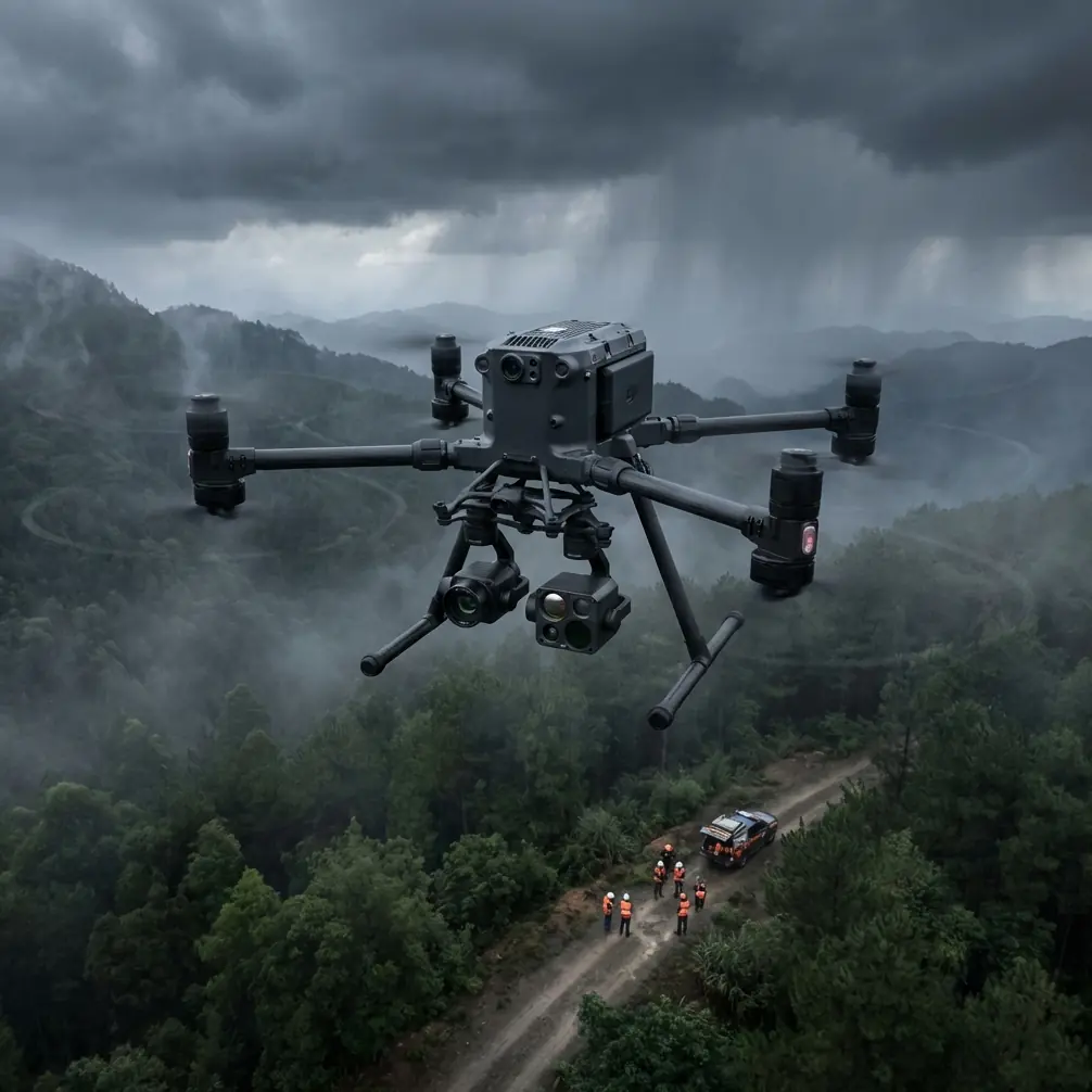
Highway surveying looks straightforward on paper. Long corridor, repeatable flight lines, predictable targets. Then the real site shows up: blowing dust from live traffic, steel guardrails and gantries reflecting signals, power infrastructure leaking electromagnetic noise, and a tight window to collect clean photogrammetry before light changes. That is where a Matrice 400 workflow either holds together or starts accumulating small errors that become expensive later.
I approach this from the field, not the brochure. For a team mapping highway assets or building corridor models, the Matrice 400 matters less as a headline platform than as a system that has to stay stable when the environment is actively trying to degrade survey quality. In dusty roadside work, the key challenge is rarely just flight endurance. It is signal integrity, payload consistency, repeatability, and the discipline to manage vibration, heat, and interference before they compromise the dataset.
The interesting part is that some of the best lessons for operating a modern UAV in these conditions echo much older aircraft engineering logic. Two reference points are especially useful here: structural design methods that deal with transitional failure zones, and actuator-control guidance that warns how instability can emerge when stiffness, load, and gain interact badly. Those are not abstract textbook concerns. They map surprisingly well to what highway drone crews deal with every day.
The highway problem is not one problem
A dusty road survey creates several simultaneous penalties.
First, dust reduces confidence in optical data. It can soften image contrast, contaminate lenses during low-altitude passes, and create inconsistency between flight blocks. That affects photogrammetry directly, especially when you need reliable reconstruction of shoulders, barriers, culverts, signage, and surface defects.
Second, corridors often include localized electromagnetic interference. Transmission lines, communications towers, variable-message signs, metal bridges, and vehicle density can all complicate compass behavior, transmission quality, and live decision-making. If you have ever watched a link degrade near a steel-heavy interchange, you already know that a drone’s communication system is only as good as its orientation and your discipline in managing the radio environment.
Third, survey flights are repetitive by design, which makes teams complacent. The route may be linear, but the conditions are not. One segment can be open and quiet; the next can become a hotspot for dust vortices and EMI reflections.
That is why Matrice 400 planning for highways needs a problem-solution mindset. You are not just drawing lines over a corridor. You are building a resilient operational envelope.
Why electromagnetic interference deserves more respect
The easiest mistake in a highway survey is treating EMI as an occasional nuisance instead of a mission variable. The fix is not panic; it is method.
In practice, I tell crews to start with antenna discipline before they start blaming the aircraft. O3 transmission performance depends heavily on line of sight, orientation, and keeping the antenna geometry aligned with the aircraft’s actual path rather than where the pilot happens to be looking. Along highways, that often means adjusting antenna angle segment by segment as the aircraft transitions past overpasses, barriers, or roadside utilities.
This sounds minor. It is not.
A poor antenna setup can mimic deeper system instability. You may see intermittent downlink weakness, delayed confidence in framing, or hesitation about whether to continue a run. When the transmission link is restored simply by reorienting the antennas to avoid reflective metal structures and maintain a cleaner propagation path, the lesson is obvious: fieldcraft still matters as much as electronics.
The reference material on flight control systems makes a useful point here. It notes that when assessing actuator dynamic response and stability, you cannot evaluate the actuator in isolation; you need the full system picture, including load mass, rotational inertia, natural frequency, damping, support stiffness, and installation gaps. That same systems thinking applies to the Matrice 400 on a highway survey. If the link looks unstable, do not diagnose only the radio. Check the full operational chain: aircraft orientation, antenna adjustment, controller position, nearby structures, route geometry, and payload behavior.
The same document also warns that under severe equal-amplitude oscillation, especially with high stiffness and heavy load, internal actuator pressure can exceed supply pressure by more than 40%. For drone operators, the direct takeaway is not about copying hydraulic design equations. It is about respecting hidden stress build-up in tightly coupled systems. When a platform is carrying a survey payload in gusty, dusty, signal-noisy conditions, small oscillations or repeated corrections are not harmless. They can cascade into poorer image sharpness, higher pilot workload, and lower confidence in the collected data.
Dust changes how you should think about survey quality
Dust is often treated as a maintenance issue. Wipe the lens. Clean the frame. Move on. That is too shallow.
For photogrammetry, dust is a data quality issue first. If airborne particles reduce contrast on repeated passes, your reconstruction consistency suffers. If fine dust settles unevenly on optics during a long corridor mission, the degradation may only show up later in stitching quality or edge fidelity. And if traffic is heavy, the dust profile can change minute by minute.
This is where disciplined mission segmentation pays off. Instead of trying to clear an entire highway section in one uninterrupted block, break the route into shorter, quality-controlled sections. Use those pauses to inspect optics, verify histogram consistency, and confirm that GCP visibility remains clean. In a dusty corridor, a beautifully planned flight with compromised image clarity is still a bad survey.
Thermal signature capture can also help, depending on the objective. Not as a replacement for photogrammetry, but as a parallel layer for identifying drainage anomalies, heat-retaining pavement defects, or equipment conditions near infrastructure. Dust may reduce visual clarity at moments, but thermal data can still provide useful context if the payload and timing are chosen intelligently. Early morning runs are often particularly effective when thermal contrast is more readable and traffic-induced heat clutter is lower.
Structural design logic has a surprising lesson for drone survey teams
One of the structural references discusses riveted panel failure and divides behavior by slenderness ratio. If L’/p is below 20, the panel behaves like a short plate in compression; above 60, it shifts toward Euler-column instability; between 20 and 60, it enters a transitional zone where failure is a coupled mode. In initial design, the handbook recommends the Euler approximation method, and it stresses that effective skin width has to be counted because buckled skin still contributes to load carrying.
Why does that matter for a Matrice 400 article?
Because highway UAV operations live in transitional zones too.
A mission is rarely either “safe and clean” or “unflyable.” Most difficult survey days sit in the middle: some dust, some EMI, some gusts, some glare, some link reflections. This is the corridor equivalent of the 20 < L’/p < 60 transition region. Operators get in trouble when they assume simple failure models in mixed conditions. They think, “The aircraft is flying, so the data must be fine,” or “The link is acceptable, so the route can continue.”
Real field reliability comes from recognizing the coupled behavior. Dust affects optics; optics affect overlap confidence; overlap confidence affects whether you repeat passes; repeated passes alter battery planning; battery planning influences whether hot-swap batteries are used aggressively; turnaround pressure can then reduce inspection discipline; all of that happens while EMI may be nudging the transmission margin.
The structural handbook’s point about effective width is also more than academic. In design, apparently compromised material may still contribute meaningfully if you model it correctly. In drone operations, that translates into not discarding a mission architecture just because one variable is degraded. A corridor survey in dust can still succeed if you account for the affected component properly: tighten segment lengths, verify GCP coverage, re-check antenna orientation, and adjust altitude or speed to preserve image quality.
Hot-swap batteries are only useful if your process is stable
Hot-swap batteries are one of those features people love mentioning because they sound efficient. In highway surveying, they are useful, but only when supported by a disciplined handoff routine.
If your team is flying long corridor sections under dust load, battery swaps should be treated as control points, not just energy refills. Use them to confirm lens cleanliness, inspect airframe inlets, check payload mounting tightness, and reassess transmission conditions ahead. If the next segment runs closer to substations or overhead lines, your antenna plan may need to change before takeoff.
This is where older control-system warnings become operationally relevant again. The source text explicitly cautions against relying on auxiliary spool-valve arrangements because their side effects can be severe, including instability and self-excited oscillation in fault scenarios. The broader message is elegant: complexity added for resilience can also create new failure pathways. In drone terms, every convenience feature, automated workflow, or rapid-turnaround habit should be tested against field stability, not just speed.
So yes, use hot-swap batteries. But use them to slow down mentally for 90 seconds and validate the next section. Corridor mapping rewards consistency more than haste.
BVLOS ambition must be matched by corridor discipline
Many teams interested in the Matrice 400 are thinking ahead to BVLOS-capable workflows for long infrastructure routes. That is sensible. Highway networks are one of the clearest civilian cases for extended-range UAV operations.
But BVLOS readiness is not created by checking a transmission-range box. It starts with proving that your operation remains stable in the ugly middle conditions: dust, partial interference, mixed elevations, roadside clutter, and variable vehicle activity. If your VLOS workflow still depends on improvising antenna orientation whenever EMI appears, you are not ready to scale the corridor safely.
The right progression is simple. Build repeatable line-of-sight procedures first. Standardize antenna adjustment practices. Log where interference clusters occur. Correlate those with terrain, structures, and downlink behavior. Then refine route templates and communication handoffs around those observed patterns.
Security also belongs in this conversation. If your highway survey data includes sensitive infrastructure detail, encrypted transmission and storage protocols matter. AES-256 is not a decorative spec in that setting. It is part of a professional workflow that treats corridor imagery, thermal layers, and mapping outputs as engineering data, not casual media.
A practical field sequence for dusty highway missions
For crews running Matrice 400 surveys along active roads, this is the sequence I prefer:
Start with a radio-aware site walk. Identify gantries, substations, long steel barriers, elevated sign structures, and any sections where terrain pinches the signal path. Mark the points where antenna adjustment will likely be needed rather than waiting to react in flight.
Then design the route in short logical blocks. Tie each block to GCP visibility and expected dust exposure. If one section sits near heavy truck flow or an unpaved shoulder, shorten it. The point is not to maximize theoretical coverage. The point is to preserve usable overlap and consistent image quality.
During flight, watch more than the map. Watch how the aircraft behaves as it passes reflective infrastructure. If the downlink or control confidence changes, correct antenna orientation first and keep notes. That local knowledge becomes a lasting operational asset.
At each battery swap, perform the same checks in the same order. Optics, payload mount, airframe dust accumulation, antenna plan, next block hazards. Repetition creates reliability.
If the mission also includes thermal signature collection, separate the thermal objective from the photogrammetry objective in your planning. Trying to optimize both at once often leads to compromise in both. Let the corridor tell you when to prioritize geometric accuracy and when to prioritize temperature contrast.
And if your team wants a second pair of eyes on corridor planning or EMI mitigation, a quick field-ops discussion can save a lot of rework later: message our UAV specialists here.
What makes the Matrice 400 the right fit here
For highway work, the Matrice 400 is not compelling because it promises abstract capability. It is compelling if it lets a survey team maintain data discipline when the corridor becomes messy.
That means stable transmission when antenna management is done properly. It means enough payload flexibility to combine photogrammetry and thermal tasks intelligently. It means battery workflows that support repeated corridor sections without degrading process quality. And it means a platform robust enough for professionals who understand that surveys fail gradually, not dramatically.
That last point is the one many teams miss. Failure in highway UAV operations often starts in the transition zone: a little dust on the lens, a little EMI near an overpass, a little more control activity in gusts, a little less consistency in overlap. The aircraft still flies. The project quietly degrades.
The engineering references behind this discussion make the same argument in different language. Structural performance changes across thresholds, and transitional regimes demand the right model. Control systems become unstable when gain, load, stiffness, and damping are misunderstood. For Matrice 400 operators, those lessons are practical. Respect coupled effects. Treat mixed conditions as their own category. Build procedures that catch small deviations before they contaminate the whole corridor dataset.
That is how a highway mission in dust becomes repeatable instead of risky.
Ready for your own Matrice 400? Contact our team for expert consultation.