Surveying Coastal Power Lines with Matrice 400
Surveying Coastal Power Lines with Matrice 400: Field Tips That Actually Matter
META: Practical Matrice 400 tips for coastal power line surveys, with expert guidance on endurance, transmission reliability, thermal workflows, photogrammetry planning, and weather-aware operations.
Coastal power line work punishes weak aircraft.
Salt haze reduces contrast. Wind shear builds around towers and escarpments. Reflections off water can throw off visual interpretation. Long linear assets stretch crews thin, and every forced landing or battery swap eats into the inspection window. If you are planning a coastal corridor survey with the Matrice 400, the aircraft itself is only part of the answer. The real advantage comes from how you configure the mission around environmental load, data quality, and repeatability.
I approach this as an operations problem, not a brochure exercise.
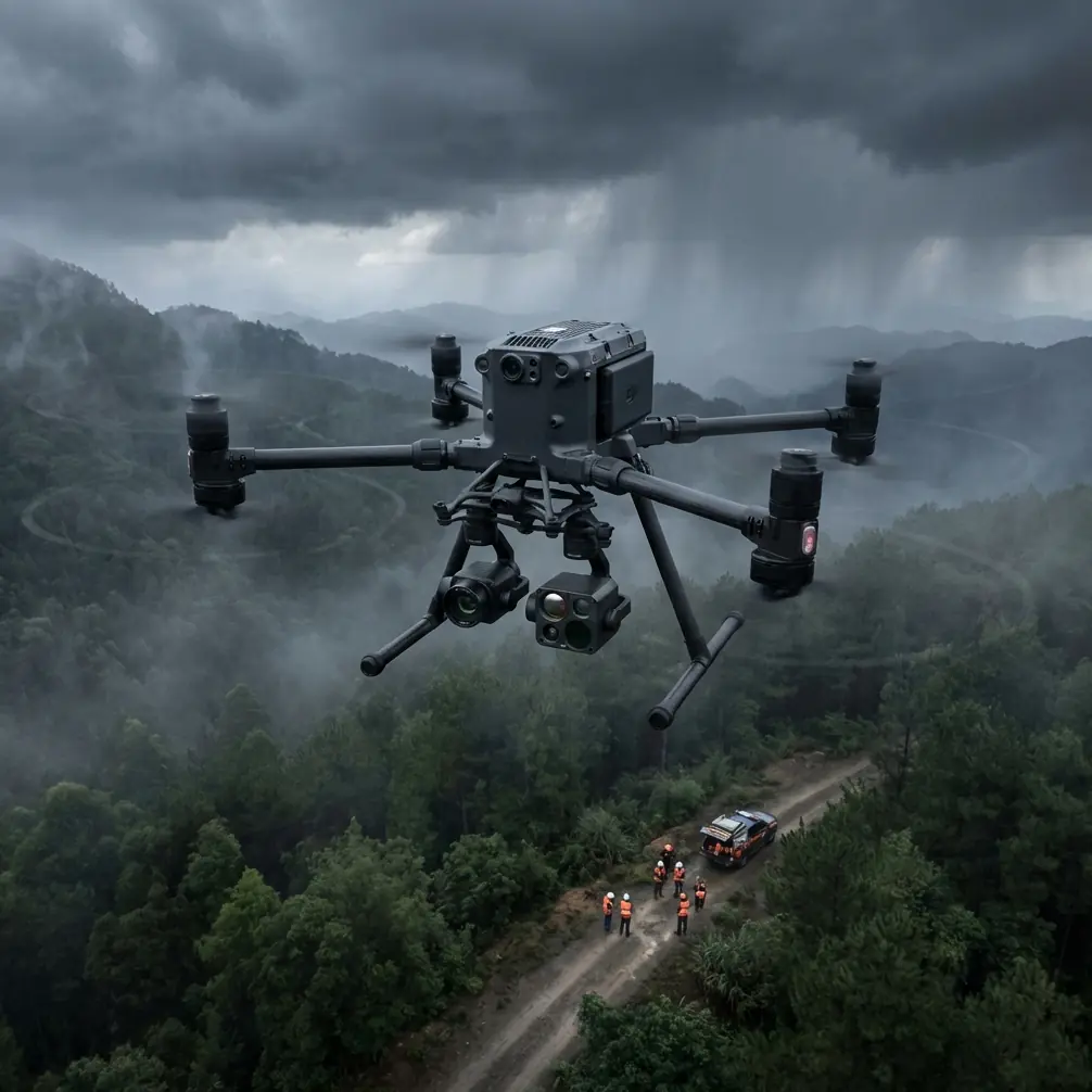
For utilities surveying transmission assets near the shoreline, the Matrice 400 sits in a useful position because it can support multi-sensor workflows while maintaining the kind of stable link and endurance needed for long corridor runs. Against lighter platforms that do well in short spot inspections but start to feel compromised when the mission expands into thermal validation, structure imaging, and mapping in the same sortie, the M400 is simply better suited to the job. That matters when you are trying to capture conductor condition, insulator anomalies, vegetation encroachment, and georeferenced tower context without running separate aircraft and separate crews.
Start with the coastal problem, not the aircraft spec sheet
Power line surveys on the coast are rarely just “inspection flights.” They are layered tasks.
You may need:
- visual imagery for hardware condition
- thermal signature review for connectors or load-related heating patterns
- photogrammetry for tower surroundings and access routes
- repeatable geo-tagged records for asset management
- secure data handling if the utility has strict internal controls
The Matrice 400 becomes valuable here because it can support that layered workflow in one platform. The practical gain is not just convenience. It is consistency. The same aircraft, the same flight controller behavior, and the same operational team reduce variability across jobs.
That is especially useful in coastal environments, where repeat passes often need to be flown in narrow weather windows.
Why transmission reliability changes everything over water and shoreline corridors
One of the first planning priorities for coastal line work is the control and video link. Shoreline routes create awkward RF conditions: open water sections, reflective surfaces, intermittent obstructions from towers, and varying elevation along cliffs or embankments.
This is where O3 transmission belongs at the center of your plan, not as a footnote. A robust transmission system helps preserve situational awareness when the aircraft is working farther down a corridor or offset from the pilot position to maintain safe geometry around energized infrastructure. Operationally, that means fewer interruptions in framing, smoother sensor control, and less time wasted repositioning the ground team just to maintain link quality.
Compared with smaller competitor platforms that may be fine for close-range tower checks but become less confidence-inspiring during extended linear work, the Matrice 400 is a stronger fit when you need stable command and image feedback over long utility runs. In coastal work, that stability translates directly into safer spacing from structures and more consistent image capture.
If your organization is preparing a BVLOS framework, transmission confidence becomes even more significant. Not because the aircraft alone makes BVLOS possible, but because reliable link performance is one of the pillars supporting a mature corridor-survey concept of operations.
The weather is not background noise
A lot of inspection teams underestimate the atmosphere near the coast. That is a mistake.
The reference materials behind classical aircraft design spend real attention on the flying environment, including standard atmosphere models and aviation weather conditions. One listed section places “标准大气” on page 285, followed by a “数据简表” on page 288, and then a section on major aviation meteorological conditions on page 291. Those are not random academic entries. They point to the same operational truth utility drone teams deal with every week: air behavior, temperature, pressure, and weather structure shape performance and data quality.
For Matrice 400 coastal surveys, that has three direct implications.
1. Battery expectations should be adjusted for marine conditions
Sea breezes can create persistent headwinds on outbound legs. Humid air and shifting temperatures also affect power management decisions. If you plan battery reserves based only on inland benchmark flights, your corridor coverage estimate will be optimistic.
2. Thermal inspections need environmental discipline
Thermal signature capture around conductors, clamps, and connectors is sensitive to sun angle, ambient temperature change, and wind cooling. On the coast, surface conditions can change faster than crews expect. A hot component seen clearly during an early pass may become harder to interpret once solar loading and airflow shift.
3. Visual mapping quality is tied to haze and visibility
The weather references also remind us that visibility is not a side issue. Salt aerosol and marine haze can soften image contrast, which affects both manual defect review and photogrammetric reconstruction.
So if you are building a serious Matrice 400 workflow, use a preflight weather model that tracks not just wind speed but also visibility trend, temperature trajectory, and coastal gust timing.
Fatigue thinking belongs in drone utility operations too
Another useful signal from the reference material comes from the helicopter design manual. It includes sections on dynamics testing and fatigue evaluation, with fatigue-related entries appearing around pages 467 to 476, including “疲劳设计基础” at page 468 and “无限寿命设计” at page 475. Even though those references belong to manned aircraft design, the operational lesson is highly relevant for utility drone teams.
Repeated vibration, cyclic loading, and structural stress matter.
Why should a Matrice 400 crew care?
Because coastal power line surveys are repetitive by nature. You will run long missions, frequent takeoffs and landings, repeated gimbal movements, and sustained exposure to gust loading. The point is not to overdramatize the aircraft structure. It is to adopt a fatigue-aware maintenance mindset. That means checking mounting interfaces, payload locks, landing gear wear points, prop condition, and gimbal dampers on a disciplined schedule rather than waiting for obvious faults.
In practical terms, the reference to dynamics testing and fatigue assessment underlines a professional habit: treat repeat-use inspection aircraft like working industrial tools subject to accumulated mechanical stress. Teams that do this well usually see better consistency in image stability and fewer preventable downtime events.
Build the mission around sensor intent
The fastest way to waste a Matrice 400 is to fly a generic route.
A coastal power line mission should be split into at least three survey intents:
Visual asset inspection
This is your close-detail pass for insulators, fittings, corrosion signs, spacer condition, and conductor attachments. Keep your line of travel predictable and your camera angles consistent from tower to tower. Repeatability helps engineers compare conditions over time.
Thermal anomaly review
Do not bolt thermal on as an afterthought. Plan a dedicated pass for thermal signature collection, ideally under conditions chosen for interpretability rather than convenience. The goal is not colorful imagery. It is decision-grade evidence.
Corridor mapping and context
This is where photogrammetry enters. Use it to capture tower surroundings, vegetation proximity, access roads, drainage impacts, and terrain conditions that affect maintenance planning. If the utility wants measurable outputs, anchor the project with GCPs where practical. Ground control is still one of the simplest ways to improve confidence in corridor mapping deliverables, especially when you need repeat surveys over time.
The M400 stands out here because it can carry the mission burden of these mixed tasks more comfortably than narrower-purpose platforms. A competitor may handle thermal. Another may handle mapping. But for a utility team trying to standardize one operational system for coastal line work, platform consolidation has real value.
Hot-swap batteries are not just a convenience feature
On coastal transmission routes, battery handling affects data continuity.
Hot-swap batteries matter because they help crews keep the aircraft and workflow moving between segments with less disruption. That reduces the temptation to rush setup or compress preflight checks just to recover time. It also helps preserve rhythm when flying tower groups in sequence.
The operational significance is bigger than saved minutes:
- less interruption between route segments
- cleaner mission continuity for corridor coverage
- more predictable crew task allocation
- lower chance of losing the ideal weather window during a full shutdown-and-restart cycle
When comparing the Matrice 400 with aircraft that require more cumbersome turnaround behavior, this is one of those features that professionals appreciate more after a month in the field than on day one.
Data security is part of utility operations now
Utilities are increasingly strict about data handling, especially when imagery reveals critical infrastructure layout, maintenance condition, and asset location details.
AES-256 matters here because it supports a higher-trust workflow for stored or transmitted operational data. For an internal inspection team or contractor working under a utility security policy, this can be the difference between a smooth approval path and a lot of compliance friction. Security features rarely get celebrated in field conversations, but in real enterprise deployment they can shape whether a platform is easy to adopt at scale.
If your team is reviewing setup options for secure corridor inspection workflows, you can message a Matrice 400 utility specialist here and compare deployment approaches before standardizing procedures.
A practical coastal flight pattern for Matrice 400
If I were setting up a repeatable M400 workflow for shoreline transmission inspection, I would use something like this:
Phase 1: Recon pass
Fly a conservative route to assess actual wind behavior near towers, note signal reflections, and identify any visibility degradation from haze. This is where you validate the day, not where you chase full data capture.
Phase 2: Visual inspection run
Execute tower-by-tower capture with standardized shot logic. Keep framing consistent. Utilities benefit more from comparable records than from creative angles.
Phase 3: Thermal pass
Re-fly the priority structures and connectors under the sensor settings and environmental timing chosen for thermal interpretation. Separate this from the visual run if conditions warrant it.
Phase 4: Photogrammetry segment
Capture corridor context and structure surroundings for engineering review, vegetation assessment, or maintenance planning. Use GCP-backed control if the output needs stronger spatial reliability.
Phase 5: Postflight fatigue-aware inspection
Before packing out, check propellers, payload mount security, gimbal isolators, and airframe contact points. Again, this echoes the larger aviation logic seen in those reference sections on dynamics testing and fatigue evaluation: repeated loading deserves repeated inspection.
Where crews usually get it wrong
Most weak results in coastal line surveys do not come from the aircraft. They come from planning shortcuts.
Common errors include:
- trying to combine thermal and visual work into a single compromised pass
- underestimating haze impact on photogrammetry
- flying too aggressively around towers because the route looks simple on a map
- treating battery swaps as a minor detail rather than a schedule variable
- skipping structured postflight checks after repeated windy sorties
The Matrice 400 gives you room to operate professionally. It does not remove the need for discipline.
Why the Matrice 400 is especially strong for this scenario
For coastal power line work, the M400’s edge is not one headline spec. It is the way several capabilities stack together:
- O3 transmission supports more stable corridor operations
- hot-swap batteries improve continuity across long linear surveys
- thermal and photogrammetry workflows can live on the same platform
- AES-256 aligns better with utility data governance
- the aircraft is simply more comfortable in complex industrial mission sets than lighter, narrower platforms
That combination is why it excels over competitors that may be easier to carry or simpler for occasional site visits, but are less convincing once the assignment becomes a repeatable utility inspection program.
A serious power line survey program needs more than flight time. It needs dependable data, secure handling, controlled workflows, and an aircraft that can tolerate repetitive industrial use. The old aircraft design references cited above may seem far removed from a modern utility drone, yet they reinforce two principles that still matter on every coastal inspection day: the atmosphere shapes your mission, and repeated structural loading is real even when the platform is unmanned.
That is the right lens for using Matrice 400 well.
Ready for your own Matrice 400? Contact our team for expert consultation.