Matrice 400 for Coastal Solar Surveys: What Actually
Matrice 400 for Coastal Solar Surveys: What Actually Matters in the Powertrain and Safety Logic
META: A field-driven look at how Matrice 400 fits coastal solar farm surveying, with practical insight on control systems, safety analysis, transmission security, thermal workflows, and long-duration operations.
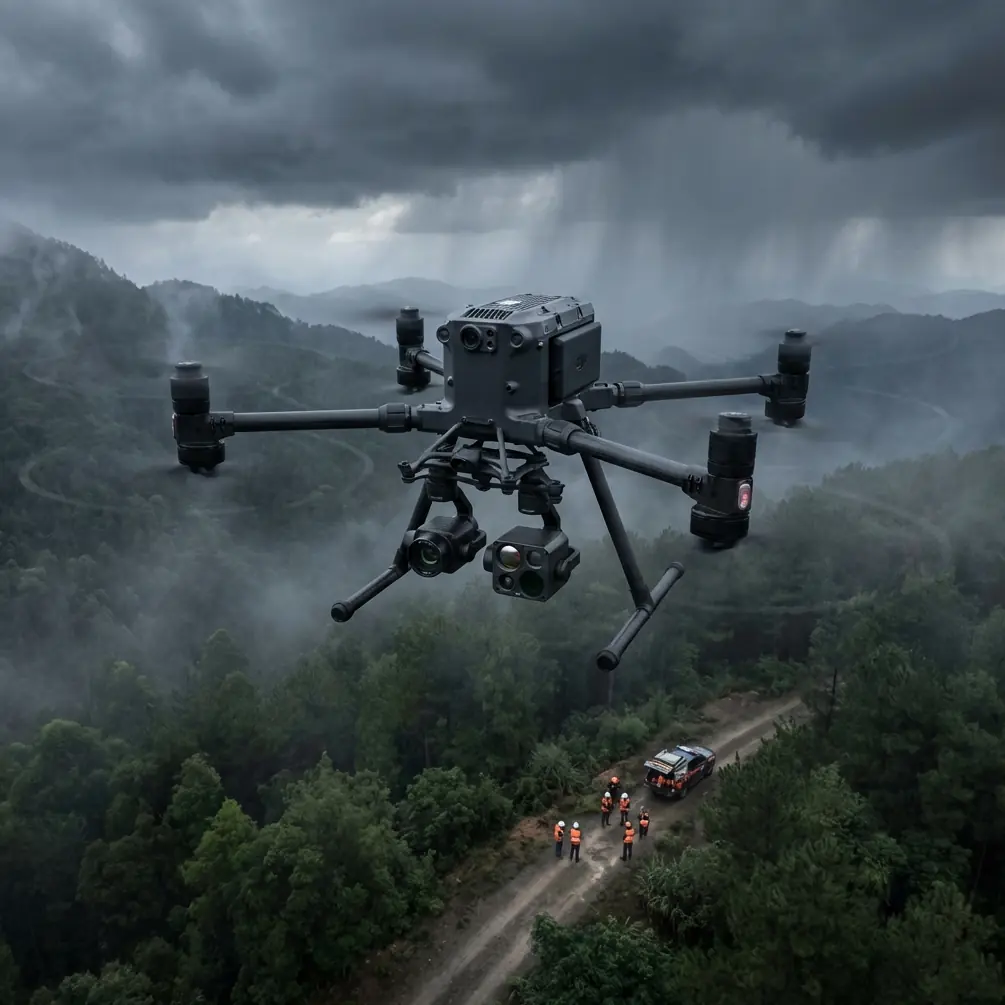
Coastal solar work exposes every weak assumption in a drone program.
Salt air creeps into connectors. Wind pushes airframes off tidy mission lines. Heat shimmer can distort visual data near noon, while low-angle light at dawn and late afternoon changes what your camera sees across thousands of panels. And if you are surveying a utility-scale site near the shoreline, you are not just collecting pretty maps. You are trying to produce repeatable, decision-grade information: thermal signature anomalies, string-level layout verification, drainage patterns, corrosion clues, hotspot clustering, and maintenance prioritization.
I learned that the hard way on a coastal array where the workflow looked fine on paper. We had decent photogrammetry, enough battery sets, and a team that knew ground control point placement. What we did not fully account for was how much mission stability depends on two things operators often treat as background details: how the aircraft manages control inputs under changing load, and how systematically the operation handles failure risk before the first takeoff.
That is why the Matrice 400 conversation should not start with a spec sheet alone. For coastal solar surveys, the more useful question is this: does the platform support disciplined operations when the environment is trying to create instability?
The hidden issue in coastal solar mapping
Most teams shopping for a new platform focus on payload options, endurance, and sensor combinations. Those matter. In a solar environment, especially one spread across reclaimed coastal land or exposed shoreline terrain, the real bottleneck is often smoother control under variable mission demands.
A drone surveying PV rows may switch between thermal collection, oblique visual capture, corridor-style mapping, and close inspection passes around substations or inverters. Every change in flight behavior creates a different demand on the aircraft’s control logic. Add crosswinds coming off the water, abrupt gusts around equipment buildings, and long repetitive runs over reflective surfaces, and you have a scenario where stable response is not a luxury. It is the difference between a clean, usable dataset and a reflight.
One of the most valuable ideas buried in classic aircraft design literature is the relationship between the engine control side and the operator command side. In the helicopter design reference provided, the control architecture is described as a combined system where the fuel-regulating portion is the main executing element, while the operator control system acts as the command input interface. That distinction matters far beyond helicopters. Operationally, it is a reminder that the aircraft has to do more than obey inputs. It has to translate them into stable power response that protects performance.
The same source also highlights a full-authority digital control approach in which the main engine control signals are transmitted digitally, calling it a modern advanced control method. Even though the Matrice 400 is not a helicopter, the principle carries over neatly into heavy-duty UAV operations: digital control architecture tends to support more precise response, cleaner signal handling, and tighter integration between pilot intent, autopilot behavior, and propulsion management.
For coastal solar survey work, that matters in three practical ways.
Why digital control logic matters on a Matrice 400 mission
First, repeatability.
When you are building thermal maps over a large array, consistency beats raw speed. A platform that reacts predictably to changing load and flight commands gives you more uniform overlap, steadier altitude maintenance, and cleaner panel-to-panel comparison. Thermal signature analysis is especially sensitive to inconsistency. A minor wobble or timing change can complicate interpretation when you are trying to distinguish true panel anomalies from capture artifacts.
Second, response under environmental disturbance.
The reference material makes a point that control design should reduce overshoot, shorten regulation time, improve constant-speed accuracy, and preserve stability. Translate that to a Matrice 400 flying over coastal solar infrastructure and the significance becomes obvious. In gusting wind, you do not want delayed correction or exaggerated response. You want the aircraft to settle quickly and keep the mission geometry intact. That has direct impact on photogrammetry alignment, thermal pass quality, and confidence in defect localization.
Third, integration with automated workflows.
Modern enterprise UAV operations are built around linked systems: flight planning, RTK or GCP-backed positioning, onboard capture triggers, cloud processing, inspection reports, and asset management exports. A platform with mature digital control foundations is simply better suited to this chain than one that feels loosely stitched together. For teams planning BVLOS-ready procedures where regulations allow, that systems discipline becomes even more valuable.
Solar farms don’t need drama. They need controlled power response.
Another detail from the helicopter reference deserves attention: the system is expected to accept load-related signals directly and adjust engine power rapidly to reduce output speed variation. In rotorcraft language, this refers to reacting to changing collective load. In UAV field terms, the lesson is broader: when operational demand shifts, the aircraft’s power management should compensate quickly enough that mission stability is preserved.
On a coastal solar site, “load” is not just payload mass. It is the total operational burden on the aircraft: wind correction, course holding, hovering for close visual checks, repeated acceleration and deceleration at row ends, and maintaining sensor quality over long-duration sorties.
This is where the Matrice 400 becomes easier to appreciate as a work platform rather than a headline machine. If you are flying a mixed workflow that starts with wide-area thermal scanning and then moves into targeted visual confirmation, the value is not just airtime. It is the platform’s ability to remain composed as mission demands shift. That composure shows up in better data continuity, fewer partial refly zones, and less operator fatigue.
And fatigue matters. Coastal sites are monotonous in a deceptive way. The rows look repetitive. The sea breeze feels manageable until it is not. Glare can wear down concentration. The more the aircraft can absorb routine control complexity, the more the crew can focus on mission quality and safety decisions.
Safety analysis is not paperwork if you operate near the coast
The second reference document, from a civil aircraft design handbook, is even more relevant than many drone teams realize. It describes safety design as a structured process, not a one-time checkbox. The text specifically calls for functional hazard analysis, fault tree analysis for hazardous or catastrophic events, and iterative revision of the design or analysis as findings emerge. It also ties safety reviews to design milestones, installation conditions, testing, and final review.
That framework is exactly how a serious Matrice 400 program should be built for commercial solar work.
Not because your operation is identical to manned aircraft certification. It is not. But because the logic is sound.
If you are deploying the Matrice 400 at coastal solar sites, your hazard analysis should not stop at “check wind, inspect propellers, brief observers.” The reference makes clear that system functions should be listed methodically, hazards should be identified from loss of function, unintended operation, and external failures, and the consequences to other systems should be considered. For a drone team, that translates into a more mature predeployment process:
- What happens if transmission quality degrades near metallic infrastructure?
- What happens if salt exposure affects connectors over time?
- What happens if thermal mission timing slips into higher irradiance conditions that distort comparison value?
- What happens if a battery swap interrupts a tight weather window?
- What happens if a mapping corridor crosses areas of poor GNSS confidence?
- What happens if one workflow depends on GCPs but the next assumes RTK-only continuity?
Those are not theoretical questions. They shape whether your final deliverable is defendable.
The same reference specifically points to fault tree analysis, or FTA, for dangerous events, with the goal of finding weak links and deciding corrective action. In drone terms, that could mean tracing a failed inspection sortie back through mission design, pilot decisions, battery handling, storage practice, firmware baselines, payload mounting, and transmission conditions. If your Matrice 400 operation includes O3 transmission and AES-256-protected data links, that should be part of your risk model too. Secure communication is not just an IT feature. On sensitive energy infrastructure, it is part of operational integrity.
Where Matrice 400 can simplify the coastal solar workflow
For this kind of site work, simplification is a major advantage.
A heavy-duty platform with dependable transmission, long mission legs, hot-swap batteries, and enterprise sensor support can compress what used to require separate sorties or awkward compromises. You can thermal scan broad panel fields, verify geometry for photogrammetry outputs, inspect drainage issues around mounting rows, and revisit suspect anomalies without rebuilding the whole day around charging downtime.
Hot-swap batteries deserve more respect than they usually get. On a coastal site, the weather often gives you narrow windows where wind, sun angle, and crew availability line up. Swapping power quickly while preserving workflow continuity can save a survey day. That is not convenience. It is schedule protection.
The same applies to transmission quality. If you are working long rows, service roads, fencing, inverter islands, and shoreline setbacks, maintaining strong situational awareness matters for both efficiency and confidence. O3 transmission has practical value here because coastal sites can appear open while still producing signal complications from infrastructure layout, reflective surfaces, and distance. A reliable link helps the pilot spend less mental bandwidth second-guessing aircraft state and more on observing mission quality.
And if your team handles owner-operator or EPC reporting, secure handling of inspection data is no small thing. AES-256 encryption is not an abstract spec to mention once and forget. When thermal captures, asset maps, and site condition records are moving across organizational boundaries, it helps reinforce trust in the workflow.
The GCP question: when precision is worth the extra setup
Coastal solar farms often challenge assumptions around control points.
Large flat arrays tempt teams to minimize GCP deployment because the terrain looks simple. Yet shoreline-adjacent conditions, repetitive geometry, and occasional access constraints can make careful ground control more valuable, not less. If the Matrice 400 is being used for photogrammetry that feeds engineering review, drainage assessment, or expansion planning, the choice between RTK-only and RTK-plus-GCP should be made intentionally.
This is another place where the safety-design mindset from the civil aircraft reference helps. The document emphasizes reviewing function, installation, interaction, and failure consequences in a structured way. Applied to mapping, that means asking how positioning assumptions propagate into decisions. If a misalignment shifts defect location or row attribution, your workflow has a systems problem, not just a mapping problem.
For many coastal projects, a hybrid approach is the sensible one: use the Matrice 400 for efficient capture, support with selected GCPs where asset density or geometry demands higher confidence, and reserve targeted reflights for questionable zones rather than blanket rework.
A better way to think about BVLOS readiness
BVLOS gets discussed as if it were mainly a regulation topic. It is not. It is also a systems maturity topic.
The handbooks behind the reference data make one point unmistakably clear: safe operation comes from structured analysis, iterative review, and designing around real failure paths. If you want to move a Matrice 400 program toward BVLOS-capable utility inspections where local rules permit, then the path is not just stronger radios or better batteries. It is a documented operational architecture.
That means clear hazard analysis, communication integrity, battery procedures, route logic, emergency planning, maintenance intervals, corrosion inspection routines for coastal exposure, and test-backed confidence in how the platform behaves when conditions are less than perfect.
That may sound dry. In practice, it is what separates scalable drone operations from teams that keep rediscovering the same preventable problems.
The past challenge I don’t want to repeat
On that earlier coastal survey, the biggest waste was not a crash or hard failure. It was operational friction. We lost time to cautious rechecks, inconsistent pass quality, and uncertainty about whether anomalies were real or capture-related. The data was usable, but not elegant. Every awkward handoff between flight execution and analysis multiplied the work.
A platform like the Matrice 400 makes that easier when it is treated as part of a disciplined system. Not because one aircraft magically solves coastal complexity, but because modern digital control, dependable transmission, secure links, and efficient power handling reduce the number of things the crew has to fight.
If you are planning a coastal solar deployment and need to sanity-check your mission design, payload mix, or control strategy, you can message the field team here. The right discussion is usually not about headline specs. It is about whether your operating method produces clean evidence under real site conditions.
What the reference material tells us about Matrice 400, indirectly but clearly
The provided reference data never mentions the Matrice 400 by name. That is exactly why it is useful.
One source explains that advanced digital control signal transmission is a modern way to manage the engine control side of an aircraft, and that the executing control system must be designed around stable response, quick regulation, and direct handling of changing load signals. The other lays out a formal chain of functional hazard analysis, fault tree analysis, safety review, and iterative revision. Put together, they describe the logic behind dependable aircraft operations.
For coastal solar surveys, that logic maps neatly onto what experienced teams need from a Matrice 400 deployment:
- precise and stable aircraft response during repetitive capture work
- resilience when environmental load changes rapidly
- mission continuity through efficient battery handling
- secure, reliable communications across sensitive infrastructure
- structured safety thinking before scaling operations
That is the real story.
The drone is only half the answer. The rest is whether the platform supports a control-and-safety philosophy strong enough for the environment you fly in. On coastal solar sites, that philosophy is what turns data collection into an operation you can trust.
Ready for your own Matrice 400? Contact our team for expert consultation.