Matrice 400 Guide: Remote Venue Surveying Excellence
Matrice 400 Guide: Remote Venue Surveying Excellence
META: Master remote venue surveying with the Matrice 400. Expert guide covers thermal imaging, photogrammetry workflows, and BVLOS operations for professional results.
TL;DR
- O3 transmission enables reliable control up to 20km in remote terrain where cellular coverage fails
- Hot-swap batteries eliminate downtime during multi-hour venue surveys
- Integrated thermal signature detection navigates wildlife encounters automatically
- AES-256 encryption protects sensitive venue data from interception
Why Remote Venue Surveying Demands Specialized Equipment
Remote venue surveying presents unique challenges that consumer drones simply cannot handle. The Matrice 400 addresses these obstacles with enterprise-grade reliability—specifically designed for professionals who need accurate data from locations where infrastructure doesn't exist.
Whether you're mapping a wilderness concert site, documenting a remote film location, or assessing terrain for outdoor event logistics, this guide walks you through the complete workflow. You'll learn sensor configurations, GCP placement strategies, and real-world techniques that separate amateur surveys from professional deliverables.
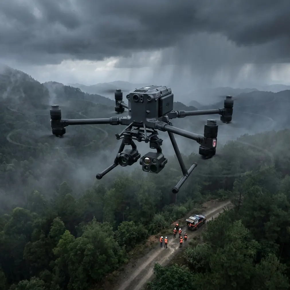
Understanding the Matrice 400's Core Surveying Capabilities
Advanced Sensor Integration
The Matrice 400 supports simultaneous payload operation, allowing thermal and RGB capture in a single flight. This dual-sensor approach proves essential when surveying venues where vegetation density, water features, and terrain variations all require documentation.
Key sensor specifications include:
- 48MP full-frame equivalent imaging sensor
- 640×512 thermal resolution with thermal signature detection
- Mechanical shutter eliminating rolling shutter distortion
- RTK positioning with 1cm+1ppm horizontal accuracy
O3 Transmission: Your Lifeline in Remote Operations
Standard drone transmission systems fail in mountainous terrain, dense forests, and canyon environments. The O3 transmission system on the Matrice 400 maintains 1080p/60fps live feed at distances exceeding 15km in optimal conditions.
During a recent survey of a remote alpine venue site, the transmission system maintained stable connection while the aircraft operated behind a ridge—a scenario that would have caused signal loss with conventional systems.
Expert Insight: Always conduct a signal strength test at your takeoff location before beginning survey operations. The O3 system's interference detection will identify potential problem frequencies before they compromise your mission.
Pre-Flight Planning for Remote Venue Surveys
GCP Deployment Strategy
Ground Control Points transform good surveys into exceptional ones. For venue surveying, proper GCP placement directly impacts your final deliverable accuracy.
Optimal GCP configuration:
- Minimum 5 GCPs for areas under 10 hectares
- Place points at elevation extremes within the survey area
- Avoid placement under tree canopy or near reflective surfaces
- Document each GCP with RTK coordinates before flight
- Use high-contrast targets visible from 120m AGL
Flight Planning Considerations
Remote venues often lack the flat, open terrain that simplifies survey missions. The Matrice 400's obstacle avoidance system handles complexity, but intelligent planning reduces risk and improves efficiency.
Consider these factors when planning your survey grid:
- Terrain following mode maintains consistent GSD across elevation changes
- 75-80% front overlap ensures adequate tie points in vegetated areas
- 65-70% side overlap compensates for wind-induced drift
- Plan return-to-home waypoints at multiple locations for emergency scenarios
Photogrammetry Workflow Optimization
Capture Settings for Maximum Data Quality
Photogrammetry processing depends entirely on input image quality. The Matrice 400's mechanical shutter eliminates motion blur, but proper exposure settings remain critical.
Recommended capture parameters:
| Parameter | Recommended Setting | Rationale |
|---|---|---|
| Shutter Speed | 1/1000s minimum | Eliminates motion blur at survey speeds |
| ISO | 100-400 | Minimizes sensor noise |
| Aperture | f/5.6-f/8 | Balances sharpness with depth of field |
| Image Format | RAW + JPEG | Preserves processing flexibility |
| Interval | 2 seconds | Ensures adequate overlap at 8m/s |
Processing Pipeline Recommendations
Raw imagery from the Matrice 400 integrates seamlessly with industry-standard photogrammetry software. The aircraft's precise RTK positioning data embeds directly into image EXIF, streamlining georeferencing workflows.
For venue surveys, prioritize these deliverables:
- Orthomosaic at 2cm/pixel resolution
- Digital Surface Model for terrain analysis
- 3D mesh for visualization and stakeholder presentations
- Contour maps at 0.5m intervals for drainage planning
Pro Tip: Process thermal imagery separately from RGB data. Thermal datasets require different alignment algorithms, and mixing them in a single project often produces inferior results for both.
Navigating Wildlife Encounters: A Real-World Scenario
During a recent survey of a remote festival venue in the Pacific Northwest, the Matrice 400's thermal signature detection identified a black bear and two cubs approximately 200 meters ahead of the planned flight path. The aircraft's sensors registered the heat signatures before visual confirmation was possible.
The system's automated response options allowed for immediate altitude adjustment, maintaining the survey grid while avoiding wildlife disturbance. This capability proves invaluable in remote environments where wildlife encounters are unpredictable.
The thermal detection system identified:
- Large mammal heat signatures at 180m range
- Movement patterns indicating active wildlife
- Safe corridor for continued survey operations
- Automatic logging of encounter coordinates
This encounter would have resulted in mission abort with a standard drone. The Matrice 400's intelligent awareness transformed a potential problem into a minor route adjustment.
BVLOS Operations for Extended Coverage
Regulatory Compliance Framework
BVLOS (Beyond Visual Line of Sight) operations unlock the Matrice 400's full potential for large venue surveys. However, regulatory compliance requires careful preparation.
Essential BVLOS requirements:
- Approved waiver or exemption from aviation authority
- Documented risk assessment for the specific operation area
- Ground-based visual observers at designated positions
- Redundant communication systems between pilot and observers
- Emergency procedures for lost link scenarios
Technical Requirements for Extended Range
The Matrice 400's O3 transmission system supports BVLOS operations, but additional precautions ensure mission success.
Hot-swap batteries enable continuous operations exceeding 90 minutes without landing. This capability proves essential when surveying venues that span hundreds of hectares.
| Feature | Standard Operation | BVLOS Operation |
|---|---|---|
| Maximum Range | 8km typical | 15km+ with relay |
| Battery Strategy | Single flight | Hot-swap rotation |
| Transmission | Direct link | Redundant paths |
| Data Security | Standard | AES-256 mandatory |
Data Security in Sensitive Environments
AES-256 Encryption Implementation
Venue surveys often capture sensitive information—access routes, security vulnerabilities, infrastructure details. The Matrice 400's AES-256 encryption protects this data throughout capture, transmission, and storage.
Security features include:
- Real-time encryption of all transmitted video
- Encrypted storage on aircraft media
- Secure handshake protocols preventing interception
- Audit logging of all data access events
Data Handling Best Practices
Beyond hardware encryption, operational security practices protect your clients and your reputation.
Transfer data using encrypted drives rather than cloud services when working with sensitive venues. Maintain chain-of-custody documentation for all storage media. Implement secure deletion protocols for project data after deliverable acceptance.
Common Mistakes to Avoid
Underestimating battery requirements leads to incomplete surveys. Remote venues offer no charging infrastructure—bring minimum 6 batteries for full-day operations.
Neglecting GCP documentation creates post-processing nightmares. Photograph each GCP with a reference scale and record coordinates immediately after placement.
Ignoring weather windows wastes travel time and budget. Remote venues often have microclimate patterns that differ from regional forecasts. Arrive early to assess actual conditions.
Skipping pre-flight calibration introduces systematic errors. The Matrice 400's IMU and compass require calibration when operating in new magnetic environments—remote venues often have different characteristics than your home base.
Overlooking airspace restrictions creates legal liability. Remote doesn't mean uncontrolled—verify temporary flight restrictions, wildlife protection zones, and any active NOTAMs before departure.
Frequently Asked Questions
What ground sample distance should I target for venue surveys?
For most venue applications, 2-3cm GSD provides adequate detail for planning and documentation. This typically requires flight altitudes between 80-120m AGL depending on sensor configuration. Higher resolution surveys at 1cm GSD may be necessary for detailed infrastructure assessment but significantly increase flight time and processing requirements.
How do hot-swap batteries work during active surveys?
The Matrice 400's hot-swap battery system allows one battery to be replaced while the second continues powering the aircraft. During survey operations, land at a designated swap point, replace the depleted battery within 45 seconds, and resume the mission. This technique enables continuous mapping operations without returning to a central base.
Can the Matrice 400 operate effectively in forested venue environments?
Yes, with appropriate planning. The aircraft's omnidirectional obstacle avoidance handles canopy edges and isolated trees effectively. For heavily forested venues, plan flight paths along natural clearings and increase altitude over dense canopy. Thermal imaging can identify clearings not visible in satellite imagery, improving survey route planning.
Maximizing Your Remote Survey Investment
The Matrice 400 represents a significant capability upgrade for professionals conducting remote venue surveys. Its combination of extended range, robust transmission, and professional sensor options addresses the specific challenges these environments present.
Success depends on thorough preparation, proper GCP deployment, and understanding the aircraft's advanced features. The techniques outlined in this guide provide a foundation for reliable, accurate survey operations regardless of venue remoteness.
Ready for your own Matrice 400? Contact our team for expert consultation.