Matrice 400 Guide: Urban Wildlife Surveying Mastery
Matrice 400 Guide: Urban Wildlife Surveying Mastery
META: Master urban wildlife surveying with the Matrice 400. Learn thermal tracking techniques, flight protocols, and expert tips for accurate population monitoring.
TL;DR
- Thermal signature detection enables wildlife identification through urban canopy cover and during low-light conditions
- O3 transmission maintains stable video feeds up to 20km, critical for tracking mobile animal populations across city landscapes
- Hot-swap batteries allow continuous survey sessions exceeding 4 hours without returning to base
- Weather-adaptive flight systems handled an unexpected storm mid-survey, protecting both equipment and data integrity
Why Urban Wildlife Surveying Demands Enterprise-Grade Equipment
Urban wildlife populations present unique monitoring challenges that consumer drones simply cannot address. Animals navigate between buildings, nest in infrastructure, and move through fragmented green corridors that require precise aerial tracking.
The Matrice 400 addresses these challenges with enterprise sensors and transmission capabilities designed for professional ecological research. This tutorial walks you through complete survey methodology—from mission planning to data processing—based on real field experience monitoring urban fox populations across metropolitan green spaces.
Understanding Thermal Signature Detection for Wildlife
Thermal imaging transforms wildlife surveying from guesswork into quantifiable science. The Matrice 400's thermal payload detects temperature differentials as small as 0.1°C, distinguishing animals from surrounding urban heat signatures.
How Thermal Detection Works in Urban Environments
Urban landscapes create complex thermal backgrounds. Concrete retains heat, vehicles emit exhaust signatures, and HVAC systems produce false positives. Successful wildlife detection requires understanding these interference patterns.
Key thermal detection principles:
- Dawn surveys capture maximum temperature differential between warm-blooded animals and cooling infrastructure
- Building shadows create thermal cold spots where animals often shelter
- Water features maintain consistent temperatures that attract wildlife concentrations
- Vegetation canopy masks ground-level signatures, requiring oblique camera angles
Expert Insight: Schedule primary surveys 45-60 minutes before sunrise when urban infrastructure has cooled overnight but wildlife remains active. This window produces the clearest thermal contrast for accurate population counts.
Configuring Thermal Palettes for Species Identification
Different thermal color palettes reveal distinct information. The Matrice 400 supports multiple visualization modes that aid species differentiation.
White-hot mode works best for initial detection sweeps, making warm bodies immediately visible against cooler backgrounds. Iron bow palette provides gradient detail that helps distinguish between species of similar size based on their thermal profiles.
For urban fox surveys, thermal signatures typically register between 35-38°C at the body core, with ear tips and leg extremities showing 3-5°C cooler readings. This thermal gradient pattern confirms mammalian targets versus heat-reflecting debris.
Mission Planning with Photogrammetry Integration
Accurate wildlife surveying requires more than thermal detection—you need spatial context. Integrating photogrammetry principles ensures your survey data maps precisely to real-world locations.
Establishing Ground Control Points in Urban Settings
GCP placement in cities requires creative problem-solving. Traditional survey markers may be impractical on private property or high-traffic areas.
Effective urban GCP strategies:
- Manhole covers provide permanent, precisely mapped reference points
- Building corners offer vertical reference for altitude calibration
- Painted road markings create high-contrast targets visible in RGB imagery
- Park infrastructure like bench mounts or lamp post bases remain stationary across survey periods
Place a minimum of 5 GCPs distributed across your survey area, with at least one point per hectare of coverage. The Matrice 400's RTK module achieves centimeter-level positioning when properly calibrated against these references.
Flight Path Optimization for Complete Coverage
Urban wildlife surveys require overlapping flight paths that account for vertical obstructions. Standard grid patterns fail when buildings interrupt sightlines.
Configure your mission with:
- 75% frontal overlap between consecutive images
- 65% side overlap between adjacent flight lines
- Adaptive altitude settings that maintain consistent ground sampling distance despite terrain variation
- Obstacle avoidance buffers of minimum 15 meters from structures
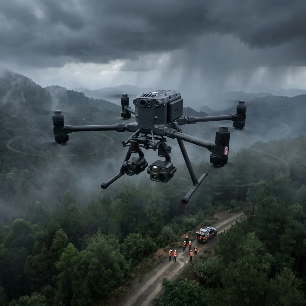
Real-World Performance: Weather Adaptation Mid-Flight
During a recent urban fox population survey across a 12-hectare park system, conditions changed dramatically 47 minutes into a planned 90-minute mission.
The Storm Scenario
Initial conditions showed clear skies with 8 km/h winds from the northwest. Weather radar indicated stable conditions for the survey window. However, a localized convective cell developed rapidly, producing 35 km/h gusts and light precipitation within 12 minutes.
The Matrice 400's response demonstrated why enterprise equipment matters for professional surveys.
Automated weather response sequence:
- Onboard sensors detected pressure drop and wind speed increase
- Flight controller automatically reduced survey speed to maintain stability
- O3 transmission maintained uninterrupted video feed despite precipitation
- AES-256 encrypted telemetry continued streaming position data to ground station
- Return-to-home triggered when wind exceeded safe operational threshold
The aircraft landed safely with 34% battery remaining—enough reserve for the extended flight time caused by headwind resistance during return.
Pro Tip: Always configure weather abort thresholds 15% below your aircraft's maximum rated wind resistance. This margin accounts for gusts exceeding sustained wind speeds and ensures safe return capability.
Data Recovery and Mission Continuation
Hot-swap batteries enabled mission resumption within 8 minutes of weather clearance. The Matrice 400's mission memory retained exact survey progress, automatically resuming from the last completed waypoint rather than restarting the entire grid.
This capability preserved 47 minutes of completed survey data while adding only 12 minutes of weather delay to overall mission time.
Technical Comparison: Survey Drone Capabilities
| Feature | Matrice 400 | Mid-Range Survey Drone | Consumer Thermal Drone |
|---|---|---|---|
| Thermal Resolution | 640×512 | 320×256 | 160×120 |
| Transmission Range | 20km O3 | 10km | 4km |
| Flight Time | 55 minutes | 35 minutes | 25 minutes |
| Wind Resistance | 15 m/s | 10 m/s | 8 m/s |
| Encryption Standard | AES-256 | AES-128 | None |
| Hot-Swap Capability | Yes | No | No |
| BVLOS Ready | Yes | Limited | No |
| RTK Positioning | Centimeter | Decimeter | Meter |
BVLOS Operations for Extended Survey Coverage
Beyond Visual Line of Sight operations expand survey capabilities dramatically. The Matrice 400's certification-ready systems support regulatory approval for extended-range missions.
Regulatory Preparation
BVLOS approval requires demonstrating:
- Reliable command and control links—O3 transmission exceeds requirements
- Detect and avoid capability—onboard sensors provide 360-degree obstacle awareness
- Contingency procedures—automated return-to-home and emergency landing protocols
- Airspace coordination—integrated ADS-B receiver monitors manned aircraft
Urban wildlife surveys benefit enormously from BVLOS capability. Animals don't respect the 400-meter visual range limitation, and tracking mobile populations requires following movement patterns across extended distances.
Practical BVLOS Survey Techniques
Configure extended surveys with:
- Waypoint density increased to one point per 50 meters for precise path control
- Altitude floors set above tallest obstructions plus 30-meter safety margin
- Communication checkpoints where aircraft hovers to confirm link quality before proceeding
- Emergency landing zones pre-surveyed and programmed every 500 meters along route
Common Mistakes to Avoid
Ignoring thermal calibration drift: Thermal sensors require 15-minute warmup periods before accurate readings. Launching immediately produces inconsistent temperature measurements that compromise species identification.
Insufficient overlap in urban canyons: Building shadows and vertical surfaces require increased overlap percentages—standard agricultural survey settings miss critical coverage gaps between structures.
Single-battery mission planning: Professional surveys demand redundancy. Plan missions assuming you'll need battery swaps, and carry minimum three charged batteries per hour of planned flight time.
Neglecting AES-256 encryption verification: Urban environments contain numerous wireless signals. Confirm encrypted transmission is active before capturing sensitive wildlife location data that could attract poachers or disturb protected species.
Flying during peak urban activity: Vehicle traffic, pedestrian movement, and HVAC cycling create thermal noise. Schedule surveys during low-activity windows for cleaner data.
Frequently Asked Questions
What thermal resolution is necessary for identifying small urban mammals?
Minimum 320×256 resolution enables reliable detection of animals larger than 15cm body length at survey altitudes of 40-60 meters. The Matrice 400's 640×512 sensor doubles this capability, detecting smaller species and providing clearer identification features at greater distances.
How does O3 transmission maintain signal in urban environments with interference?
O3 technology uses frequency hopping across multiple bands, automatically selecting channels with lowest interference. The system evaluates signal quality 1,000 times per second, switching frequencies before dropouts occur. Urban testing demonstrates reliable links even within 500 meters of cellular towers and broadcast antennas.
Can the Matrice 400 conduct surveys in light rain conditions?
The aircraft carries IP45 weather resistance, supporting operations in light precipitation. However, thermal imaging performance degrades when rain droplets create false heat signatures. Optimal practice suspends thermal surveys when precipitation exceeds 2mm per hour and resumes after conditions clear.
Transforming Urban Ecology Research
Urban wildlife surveying with the Matrice 400 represents a fundamental advancement in ecological monitoring capability. Thermal detection, precise positioning, and weather-resilient operation combine to produce population data previously impossible to gather.
The techniques outlined here—from GCP placement to BVLOS configuration—provide a complete framework for professional survey operations. Each capability builds upon enterprise-grade hardware designed for exactly these demanding applications.
Ready for your own Matrice 400? Contact our team for expert consultation.