Matrice 400 for Urban Wildlife Surveys: A Field
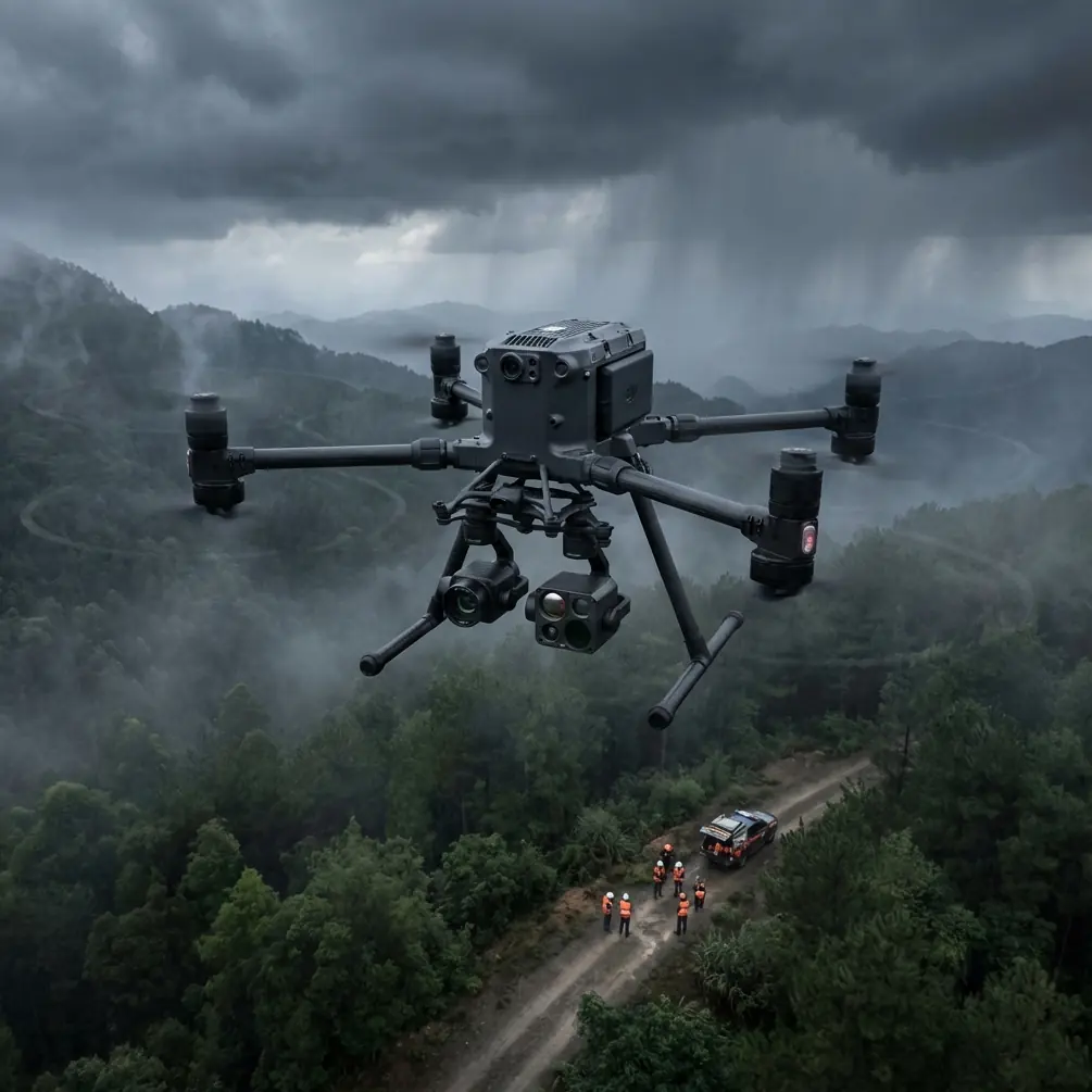
Matrice 400 for Urban Wildlife Surveys: A Field-First Approach to Cleaner Data and Safer Flights
META: Expert guide to using the DJI Matrice 400 for urban wildlife surveys, with practical insights on thermal signature capture, photogrammetry, GCP workflow, O3 transmission, AES-256 security, hot-swap batteries, BVLOS planning, and EMI antenna handling.
Urban wildlife surveys are rarely limited by animal behavior alone. In most cities, the harder problem is the environment around the animals: reflective glass, dense RF noise, rooftop turbulence, patchy GNSS conditions, and tight launch windows between people, traffic, and site access rules. That is where the Matrice 400 becomes interesting—not as a spec-sheet exercise, but as a working platform for gathering dependable ecological data in places that fight back.
If your job is counting roosting birds on warehouse roofs, checking bat emergence corridors along bridges, mapping nesting habitat beside rail assets, or detecting thermal movement in fragmented green spaces, the aircraft matters less than the integrity of the data it can deliver under pressure. The Matrice 400 sits in that conversation because it addresses three urban survey problems at once: payload flexibility, continuity in the field, and link reliability in hostile electromagnetic conditions.
The real challenge in urban wildlife work
Wildlife teams operating in cities usually need more than one kind of evidence. A thermal pass can reveal presence and movement when visible imagery cannot. A photogrammetry run can produce measurable habitat models, canopy edges, roof features, or waterline context. A repeatable mission profile helps compare one survey window to the next.
The trouble is that cities degrade all three.
Thermal signature collection becomes messy when HVAC exhaust, sun-warmed cladding, asphalt heat retention, and vehicle traffic pollute the scene. Photogrammetry suffers when flight lines are interrupted, overlap drops near obstacles, or control is weak around reflective infrastructure. And even a carefully planned mission can unravel when electromagnetic interference starts chewing at the control and video link.
The Matrice 400 is best understood as a response to that operating reality. Not because it eliminates those variables, but because it gives survey crews more ways to manage them without compromising safety or data quality.
Why the platform matters for wildlife, not just inspection
A lot of heavy-lift enterprise aircraft are discussed through an infrastructure lens. That misses the point for environmental work. Urban wildlife teams often need to swap between payload objectives quickly: thermal observation at dawn, visual documentation after sunrise, then an orthomosaic or low-altitude 3D capture over a specific habitat patch. A platform built for modular work reduces downtime between those tasks.
That is where hot-swap batteries become operationally significant. On paper, battery replacement speed sounds like a convenience feature. In actual wildlife work, it can preserve a survey window. Early morning thermal contrast can collapse fast as roofs and roads begin heating. If you have to power down fully and lose your rhythm between sorties, the quality of your dataset changes with the temperature of the city. Hot-swap support allows a crew to keep the aircraft active while exchanging packs, which means less drift between passes and less wasted time while a target species changes behavior.
The same logic applies during repeated transects in urban green corridors. If you are documenting bird movement between tree lines, retention ponds, and rooftops, continuity helps. You want consistent altitude, timing, and sensor behavior, not a stop-start workflow that introduces unnecessary variation.
Thermal work in cities: what the Matrice 400 makes easier
Thermal imaging for wildlife is often misunderstood. It is not simply about “seeing heat.” It is about separating a meaningful thermal signature from the noise of the built environment. A pigeon colony under a bridge deck, bats leaving a crevice, or mammals using a rail embankment at first light all produce signatures that can be masked by surrounding structures.
A heavier enterprise platform such as the Matrice 400 is useful here because stable flight matters to thermal interpretation. Small corrections, yaw oscillation, or inconsistent speed across a pass can make a warm target harder to classify when you review imagery frame by frame. In urban wildlife surveys, stable positioning is not just a pilot comfort issue. It affects whether the thermal record stands up when ecologists compare count estimates or movement patterns later.
The second advantage is payload compatibility and workflow discipline. Thermal data is most valuable when tied to visible context and accurate geospatial reference. If a survey team can gather heat signatures and then follow with photogrammetry over the same area, they can connect animal presence to habitat structure rather than producing isolated thermal clips with limited planning value.
That matters when the question is not only “What was there?” but “Why is this site being used?”
Photogrammetry is more useful when paired with ecology questions
Urban wildlife clients increasingly want more than simple presence-absence reporting. They want habitat condition, disturbance context, repeatability, and evidence they can compare across seasons. Photogrammetry turns a flight from an observation exercise into a measurement exercise.
With the Matrice 400, photogrammetry becomes practical in mixed urban terrain because the aircraft is designed around enterprise-grade mission execution rather than ad hoc visual capture. For habitat mapping, consistent overlap and planned track geometry are essential. That is especially true where rooftop parapets, courtyards, tree canopies, and narrow linear corridors create vertical complexity.
This is where GCP workflow enters the picture. Ground control points are not glamorous, but they remain one of the clearest ways to improve confidence in mapping outputs. In urban wildlife surveys, GCPs can anchor orthomosaics and surface models so ecologists can reliably measure nesting zones, vegetation patch boundaries, shoreline encroachment, or access routes near sensitive habitat. Without that control, even visually sharp outputs can become less defensible when decisions depend on exact location or dimensional comparison over time.
The key operational takeaway is simple: the Matrice 400 should not be used just to collect images. It should be used to support a structured capture workflow in which thermal detection, visual confirmation, and geospatially controlled photogrammetry feed the same ecological question.
O3 transmission and why it changes field confidence
Most discussions of transmission systems focus on range. Urban wildlife teams should care at least as much about resilience. O3 transmission is relevant not because every survey is long-distance, but because city environments are full of signal clutter. Wi-Fi saturation, rooftop telecom equipment, reflective façades, utility infrastructure, and moving vehicles can all complicate the link between aircraft and crew.
Reliable transmission affects more than convenience. It affects whether an observer can confidently identify species behavior in real time, whether a pilot can hold mission quality around obstacles, and whether a thermal target can be marked for immediate follow-up before the opportunity disappears.
In practical terms, urban RF interference is rarely solved by panic. It is managed through orientation, line of sight, launch placement, and antenna discipline. One of the most useful habits with a platform like the Matrice 400 is to treat antenna adjustment as an active part of the mission rather than a setup chore you forget after takeoff.
If you begin to see signal quality dip near dense building clusters or metal-heavy structures, the fix is often not to climb blindly or abandon the run. Reassess the aircraft’s relative position, maintain cleaner geometry between controller and airframe, and adjust antenna orientation deliberately so the transmission path is not fighting avoidable obstructions. In urban wildlife work, this can preserve a survey over a sensitive nesting area without forcing a rushed reposition that disturbs the site.
That handling discipline is one of those small professional differences that separates a usable data day from a compromised one.
Security matters when wildlife data is sensitive
Not every wildlife survey dataset is public-facing. Some involve species location sensitivity, private industrial land, utility corridors, university sites, water facilities, or critical urban habitats where access and coordinates should be tightly controlled. That is why AES-256 deserves more attention than it usually gets in drone conversations.
AES-256 encryption is operationally significant because it helps protect the integrity of transmitted data and mission communications. For ecological consultants, NGOs, and land managers, that matters when the survey involves vulnerable species locations or commercially sensitive infrastructure near habitat zones. The point is not abstract cybersecurity language. The point is that location intelligence has consequences, and professional survey programs should treat data handling with the same seriousness they give flight safety.
On projects with multiple stakeholders, strong transmission security can also make it easier to integrate drone operations into broader governance requirements. That is increasingly relevant in cities where environmental studies intersect with transport operators, developers, utilities, and public land authorities.
BVLOS planning is about efficiency, not just distance
BVLOS gets mentioned often, usually as a marker of advanced operations. For urban wildlife work, the better lens is efficiency under controlled conditions. Some wildlife corridors run along canals, utility easements, coastlines, or fragmented park systems where line-of-sight operations create repeated setup delays. A Matrice 400 workflow built with BVLOS planning principles can improve coverage, reduce unnecessary repositioning, and support more consistent mission geometry.
That does not mean forcing every survey into a BVLOS model. It means planning routes, observers, contingency areas, communications, and airspace coordination in a way that scales when the corridor is longer than one practical visual segment. Even when the operation remains within sight, BVLOS-style discipline tends to improve mission design.
For wildlife teams, that translates into better repeatability. The same corridor can be flown with more consistency from one season to the next, making trend analysis more credible.
A practical urban workflow for the Matrice 400
A strong urban wildlife mission with this platform usually follows a sequence rather than a single pass.
Start before first light if thermal contrast is central to the objective. Use initial sorties to identify active zones, movement paths, and thermal anomalies worth verifying. Keep flight behavior disciplined and avoid overflying unnecessarily close to target fauna. The goal is detection with minimal disturbance.
Then transition to visible data collection after ambient conditions improve. If the project requires mapping, establish GCPs where safe and legally permitted so your orthomosaic or 3D output has defensible control. Fly photogrammetry lines with enough overlap to handle the vertical complexity of city habitat patches. Rooftop edges, tree crowns, bridge understructures, and embankments all benefit from planning that respects relief variation.
During each phase, monitor the link actively. In interference-prone areas, antenna adjustment should be treated as part of flight management. A small change in controller orientation or crew position can stabilize the O3 link without breaking mission flow. On long mornings, hot-swap battery capability helps preserve continuity as the environmental conditions shift.
Finally, merge the outputs. Thermal clips identify occupancy. Visible imagery confirms context. Photogrammetry explains structure. Together, they produce a survey that is not only persuasive to clients, but genuinely useful to ecologists and planners.
Where the Matrice 400 fits best
The Matrice 400 is not for every wildlife task. If your work is limited to quick visual checks in open rural fields, a lighter platform may be enough. But in urban environments—where data quality, payload flexibility, RF resilience, and operational continuity all carry weight—it starts to make a lot of sense.
Its value shows up in the margins that decide whether a mission succeeds: maintaining a secure AES-256 transmission path when site sensitivity matters, preserving a dawn thermal window through hot-swap batteries, and using O3 transmission with smart antenna adjustment to stay productive around electromagnetic interference. Add a disciplined photogrammetry workflow with GCP support, and the aircraft becomes more than a camera carrier. It becomes a reliable survey instrument.
That is the distinction professionals should care about.
If you are designing an urban wildlife program around the Matrice 400 and need help with payload choice, mapping workflow, or interference-aware mission planning, you can message an enterprise drone specialist here.
Ready for your own Matrice 400? Contact our team for expert consultation.