Matrice 400 Field Report: Surveying Wildlife in Complex
Matrice 400 Field Report: Surveying Wildlife in Complex Terrain Without Losing the Plot
META: Expert field report on using the DJI Matrice 400 for wildlife surveying in steep, obstructed terrain, with practical insight on thermal work, photogrammetry, O3 transmission, hot-swap batteries, GCPs, and BVLOS planning.
By James Mitchell
The hard part about wildlife surveying is rarely just finding animals. It is finding them early enough, cleanly enough, and repeatedly enough to build data you can defend later.
That becomes painfully clear in broken terrain. Deep gullies distort line of sight. Tree cover fragments thermal contrast. Ridge faces create wind shear that looks manageable from the truck and turns messy once the aircraft is working the slope. If you are trying to document population movement, identify nesting zones, or build a photogrammetric model of habitat conditions, the aircraft matters less as a flying camera and more as a stable data platform that can keep producing usable information when the landscape is doing everything it can to interrupt the mission.
That is where the Matrice 400 becomes interesting.
This is not a generic overview. It is a field-driven look at what the Matrice 400 means for wildlife teams operating in complex terrain, especially when the job includes both visual observation and mapped habitat documentation on the same deployment.
A morning on the ridge
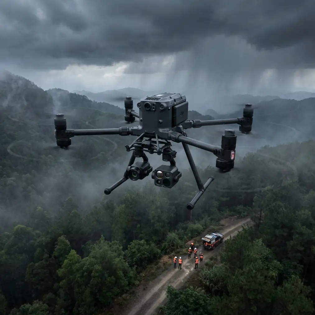
One of the more revealing moments I have seen with this class of platform happened during an early-morning wildlife survey above a cut valley where scrub, rock shelves, and patchy conifers all met in one compressed corridor. The goal was straightforward on paper: verify movement through a known crossing zone, collect thermal detections before the sun flattened contrast, then run a follow-up mapping pass for habitat analysis.
Simple enough until a pair of mountain ungulates emerged from shadow near a rock break, moved behind scattered cover, and effectively disappeared to the naked eye from our ground position. From the aircraft, though, their thermal signature held just long enough to maintain track as they crossed from cooler stone into low brush. That transition mattered. On a lesser setup, you might log a probable sighting and move on. With a stable aerial platform carrying the right sensing package, you can record the actual route, correlate it to terrain features, and then map the surrounding surface conditions for repeat analysis later.
That is the difference between observation and survey-grade fieldwork.
Why the Matrice 400 fits this kind of work
For wildlife teams, the Matrice 400 sits in a useful middle ground: large enough to support serious sensor operations and long-duration tasking, yet still practical for field teams that need to move between launch points in a single day.
The key advantage is not one single specification. It is the combination of endurance, transmission reliability, payload flexibility, and operational continuity. In complex terrain, every interruption costs more than time. If you lose signal around a ridge shoulder, swap aircraft because batteries are exhausted mid-window, or return with imagery that cannot be aligned to control, the field day starts unraveling.
This is where a few capabilities matter operationally, not just on a spec sheet.
O3 transmission is not a luxury in obstructed terrain
In wildlife missions, terrain is the adversary. Dense canopy, cliffs, folds in the land, and uneven launch elevations all test your link budget. O3 transmission matters here because it helps preserve situational awareness when the aircraft is working around visual obstructions and varying topography. That is not just about keeping a live image on screen. It affects route decisions, sensor confidence, and whether the pilot can safely maintain mission continuity as the aircraft moves through terrain-induced interference zones.
For wildlife survey crews, a stronger transmission system often means fewer abandoned passes and less need to reposition the team just to regain confidence in the feed. In steep ground, that is a real operational gain.
AES-256 has field significance when your data is sensitive
Wildlife work is not always public-facing. Nesting locations, migration corridors, endangered species observations, and concession-bound environmental assessments can all involve sensitive geospatial data. AES-256 encryption matters because the aircraft is not just collecting pretty footage; it is often carrying ecological evidence with location value. Whether the mission supports a conservation body, environmental consultant, or land manager, protecting the transmission chain and recorded data is part of professional practice.
That detail is easy to overlook until you are handling habitat records that should not circulate casually.
Hot-swap batteries change what a survey day looks like
Battery endurance gets discussed constantly, but hot-swap batteries are the detail that field teams appreciate most after a few serious deployments.
Wildlife encounters do not respect your battery cycle. Dawn thermal windows are short. Animal movement may spike unexpectedly. A cliff-side nest check might only become possible once local wind settles. When the platform supports hot-swap battery operations, teams can rotate packs with far less disruption between sorties. The aircraft gets back to work faster, and the crew keeps the mission rhythm intact.
That matters more than people realize in habitat documentation. If you thermal-scout an area at first light and then want a follow-up photogrammetry pass while environmental conditions remain stable, quick turnaround is a major advantage. You preserve overlap planning, maintain crew focus, and keep the site context fresh in everyone’s head.
Thermal first, photogrammetry second
For wildlife surveys in complex terrain, one of the best workflows with the Matrice 400 is to separate the mission into two linked objectives rather than forcing one sensor pass to do everything.
Start with thermal.
Thermal detection is often strongest during low-sun periods when ground surfaces have not equalized. In broken country, animals can vanish visually behind vegetation or blend into background texture, while their heat contrast still gives them away. But thermal alone is not enough if your end product must support habitat assessment, route analysis, or environmental reporting.
That is where photogrammetry enters the sequence.
After locating movement corridors or behavior hotspots, run a structured visual mapping mission to produce a high-resolution model of the area. The significance is practical: now your wildlife detections can be interpreted against slope, drainage, canopy breaks, rock shelter, and access routes. Instead of saying animals were present in a general zone, you can document how terrain likely shaped their movement.
This is especially useful when teams need to revisit the same site over time. A repeatable orthomosaic or 3D surface model helps compare seasonal vegetation change, erosion, or habitat disturbance against observed wildlife activity.
GCPs still matter, even with a smart aircraft
There is a temptation with advanced platforms to skip the discipline of proper control. That is a mistake.
If the Matrice 400 is being used for photogrammetry in support of environmental monitoring, Ground Control Points remain one of the clearest ways to strengthen positional trust in the finished output. In rugged terrain, where elevation shifts and image geometry can complicate reconstruction, GCPs provide a known framework that helps tie the model to real coordinates.
Their operational significance is simple: better control means stronger repeatability. If a conservation team returns in three months to compare trail widening, watercourse change, or vegetation stress near an active wildlife corridor, they need confidence that differences in the dataset reflect the landscape, not loose alignment.
That is why I still advise crews to place and verify GCPs whenever the site and mission scope justify it. The aircraft can do a great deal. Good survey habits still do the rest.
Complex terrain changes how you plan BVLOS-type workflows
BVLOS is one of those terms people throw around too casually. For wildlife operations, the real issue is not ambition but risk structure. In large protected areas, valleys, coastal escarpments, or forested uplands, survey targets may fall beyond practical visual coverage from a single launch point. That is why BVLOS planning keeps entering the conversation around larger enterprise aircraft like the Matrice 400.
The significance is not that every wildlife crew should rush into long-range operations. It is that the aircraft is suited to workflows where distance, transmission integrity, route discipline, and operational redundancy all matter. Even when missions remain within regulatory visual limits, planning them with BVLOS-style rigor improves outcomes. You think harder about terrain masking, emergency routes, communication handoff, battery reserve, and recovery options.
That mindset pays off.
In wildlife surveying, disciplined route planning reduces unnecessary overflight, lowers disturbance risk, and improves the odds of coming home with data that can actually be used.
Sensor behavior matters as much as aircraft behavior
When readers ask whether the Matrice 400 is “good for wildlife,” the question is too broad to be useful. The better question is whether the platform helps sensors do meaningful work in imperfect conditions.
That is where the aircraft earns its place.
A stable, mission-oriented platform allows thermal and visual payloads to be used deliberately rather than reactively. You can hold an observation angle over a slope break without fighting the airframe. You can transition from detection work to mapping work without changing the entire field setup. You can use one deployment to gather multiple layers of evidence: thermal presence, visual confirmation, terrain context, and mapped habitat condition.
In practical terms, that means fewer compromises.
You are not choosing between spotting animals and documenting the site. You are structuring the mission to do both.
What crews should get right before launch
The Matrice 400 can support strong field outcomes, but wildlife survey quality still depends on method. Before launch, I would focus on five points.
First, define whether the primary output is detection, counting, habitat mapping, or change analysis. Those are not the same mission.
Second, match the time of day to the sensing objective. Thermal windows are fleeting. Photogrammetry usually benefits from more consistent light.
Third, decide early whether GCPs are necessary. If the output will support repeated comparison or environmental reporting, they usually are.
Fourth, treat transmission planning seriously. O3 gives you a stronger operating envelope, but ridges and canopy still win if you ignore terrain.
Fifth, build battery rotation around the survey window, not around convenience. Hot-swap capability helps only if the crew has already organized charging, pack order, and relaunch procedures.
None of this is glamorous. All of it affects data quality.
The larger value of the Matrice 400 in wildlife work
The strongest case for the Matrice 400 in this sector is not that it does one thing no other aircraft can do. It is that it supports professional wildlife survey workflows without forcing constant tradeoffs between endurance, sensor utility, mapping discipline, and operational resilience.
For teams working in complex terrain, that balance matters.
An aircraft that can maintain a reliable link through difficult topography, protect sensitive environmental data with AES-256, support rapid turnaround through hot-swap batteries, and carry out both thermal detection and photogrammetry is not just convenient. It changes what kinds of field days are feasible.
And in wildlife work, feasibility is everything.
Conditions shift. Animals move unpredictably. Light changes by the minute. The best aircraft is the one that lets the team adapt without collapsing the integrity of the mission.
That is the Matrice 400 story as I see it: not a machine for spectacle, but a platform for disciplined observation in places where the landscape refuses to cooperate.
If you are planning a Matrice 400 workflow for wildlife corridors, habitat mapping, or conservation survey design and want to compare sensor setups or field procedures, you can message the team here.
Ready for your own Matrice 400? Contact our team for expert consultation.