Mountain Wildlife Surveying With Matrice 400
Mountain Wildlife Surveying With Matrice 400: A Field Case Study on Stability, Control Logic, and Payload Strategy
META: A specialist case study on using Matrice 400 for mountain wildlife surveying, with practical insight on thermal detection, photogrammetry, control stability, transmission resilience, and accessory-driven field performance.
Mountain wildlife surveys punish weak aircraft designs.
The problem is not simply distance. It is the mix: thin air, abrupt ridge lift, cold starts before sunrise, patchy GNSS visibility in narrow valleys, and the need to switch between broad-area search and careful observation without disturbing animals. In that environment, the Matrice 400 becomes interesting not because it is a flagship platform on paper, but because mountain work exposes whether a drone’s structure, control system, and payload ecosystem are genuinely integrated.
I recently reviewed a mountain wildlife survey workflow through the lens of two old but still useful aircraft design references: one focused on structural design, the other on flight control and hydraulic system design. At first glance, neither source mentions Matrice 400. Yet they highlight something many drone buyers skip over: aircraft capability is not just a matter of sensors or endurance. It is the result of how structure, control logic, cross-linked systems, and maintenance priorities are designed to work together under stress.
For wildlife teams operating in steep terrain, that distinction matters.
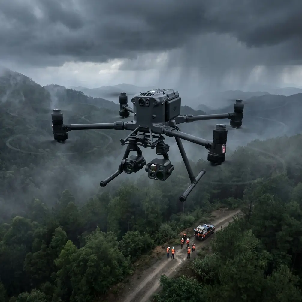
The mission profile: counting what you cannot easily approach
The survey objective was straightforward. A field team needed to identify animal presence across a mountainous corridor, map habitat use, and collect image data suitable for later analysis. In practice, that required two very different outputs from one aircraft:
- thermal detection during low-light windows to spot animals by heat contrast
- visible-light mapping for photogrammetry and habitat assessment
That is where Matrice 400 fits the job. It can support a layered workflow rather than a single-task flight. In mountain wildlife work, that means searching with thermal signature data first, then returning over the same sector with a mapping pattern tied to GCP-backed photogrammetry.
This sounds ordinary until terrain gets involved. Mountain updrafts and crosswinds do not simply shake the aircraft. They degrade image consistency, make manual repositioning less efficient, and increase the pilot’s workload at exactly the moment when precise sensor pointing matters most.
The old flight-control reference is useful here. In Chapter 3, it discusses “automatic flight control systems and augmentation systems,” including attitude hold, heading hold, altitude hold, and typical lateral-directional augmentation control. Those are not abstract engineering topics. In field terms, they explain why a stable aircraft can keep a thermal subject in frame on a ridge face instead of forcing the operator into constant corrections.
That operational significance is often underestimated. If the aircraft can maintain attitude and heading cleanly while the payload operator tracks movement below, the entire mission gets better: less blurred data, less pilot fatigue, and fewer broken survey lines.
Why control augmentation matters more in mountains than on flat sites
On a flat agricultural block, a brief gust usually means a minor correction. In mountain surveys, gusts arrive with shape. They roll off ridgelines, curl through saddles, and accelerate inside drainage channels. A drone that is merely “flyable” becomes exhausting to operate over a long sortie.
The source material’s discussion of “typical lateral-directional augmentation control” on page 407 and “automatic trim and autopilot return-to-zero” around page 396 points to a deeper truth: good control systems reduce the effort required to keep the aircraft in a known state. For a Matrice 400 wildlife team, this shows up in three ways.
First, route fidelity improves. When flying photogrammetry lines over sloped terrain, stable cross-track behavior helps maintain overlap consistency. That directly supports cleaner processing later, especially when the team is tying imagery to GCPs for habitat analysis.
Second, observation quality improves. During thermal passes, animals may appear only briefly through canopy gaps or on exposed rock shelves. If the aircraft can hold position and orientation smoothly, the payload operator has a better chance of distinguishing a genuine thermal signature from a false positive caused by motion or angle shifts.
Third, operator bandwidth is preserved. In mountain work, people are already monitoring weather, topographic clearance, battery planning, and link quality. Every bit of aircraft self-discipline gives the crew more capacity to think.
This is one reason O3 transmission and AES-256 matter in the Matrice 400 conversation, even when wildlife teams are not fixated on spec sheets. O3 transmission supports command and image-link continuity in terrain where line-of-sight can change quickly. AES-256 adds confidence when survey data includes sensitive location information for protected species. Not every wildlife project needs encrypted transmission at the center of the brief, but many conservation teams now treat species location privacy as part of ethical field practice.
Structural thinking still matters in a modern UAV
The structural design reference is even more revealing. It includes sections on structural layout, control-surface connection mechanisms, maintenance-oriented design concerns, corrosion protection, and even sudden cabin decompression considerations in manned aircraft. Some of those topics do not directly map onto an uncrewed multirotor. But the mindset absolutely does.
The important lesson is that aircraft design should anticipate what happens when the environment starts stressing joints, surfaces, seals, and service access.
One detail from the source stands out: the emphasis on maintenance-focused design in section 15.4.1, listed on page 482. Another is the attention to sealing and material choice in the pressurized cabin chapter, where structural sealing forms and sealing-material selection appear on pages 560 and 571. A Matrice 400 is not a pressurized aircraft, of course, but mountain wildlife operations still benefit from the same design philosophy. Why? Because cold, moisture, dust, and repeated field deployment all punish poor interfaces.
In practical terms, crews working from mountain staging points need fast inspections, predictable component access, and confidence that environmental exposure will not create hidden reliability problems. That is also why hot-swap batteries are not just a convenience feature. They are an operational tool. When daylight, weather windows, and animal activity periods are narrow, the ability to change batteries without fully resetting the workflow preserves mission tempo.
That can be the difference between catching dawn thermal movement and arriving ten minutes too late, after rock faces have already begun heating unevenly.
The accessory that changed the mission
The most useful upgrade in this case was not exotic. It was a third-party high-gain directional antenna kit used at the ground station.
On paper, that may seem secondary compared with payload choice. In the mountains, it was decisive. The team was surveying along broken ridgelines where the aircraft periodically moved into geometries that weakened the downlink. The antenna kit improved link consistency enough to let the crew hold safer standoff positions instead of chasing terrain with the pilot’s vehicle or relocating repeatedly on foot.
That kind of accessory does more than extend convenience. It changes mission architecture. Better link performance means the crew can select takeoff points based on safety and observation value rather than only on signal compromise. Combined with O3 transmission, it produced a more stable operating envelope in difficult topography.
A case like this also explains why BVLOS is discussed so often around Matrice platforms, though the real-world answer always depends on local regulations, waivers, training, detect-and-avoid procedures, and site-specific risk controls. In mountain wildlife surveying, many corridors are long, narrow, and inaccessible. Even when the mission is not formally BVLOS, planning principles borrowed from BVLOS thinking—communications resilience, battery contingencies, terrain masking awareness, and recovery options—make the operation stronger.
Thermal first, photogrammetry second
The actual workflow was built around timing.
Before sunrise, the crew launched the Matrice 400 with thermal capability to scan south-facing slopes, drainage lines, and sheltered benches. At that hour, animal heat signatures separated more clearly from the background. A thermal image is not species proof by itself, but it is an efficient way to locate movement and prioritize follow-up.
Later, once the light was suitable, the team shifted to visible-spectrum collection for photogrammetry. This second phase focused on terrain context, vegetation edges, game trails, and possible bedding or grazing zones. GCPs were used in selected accessible areas to strengthen geospatial accuracy, especially where the deliverable would later be compared against prior habitat maps.
This is where the Matrice 400’s value becomes less about raw flight time and more about workflow continuity. One aircraft, one trained crew, and one integrated data chain can cover detection, confirmation, and mapping. That reduces the usual frictions between separate drone teams or separate airframes.
The old control-system reference again becomes relevant. Its section on “system verification and quality assurance” is not fully visible in the extract, but the chapter structure clearly points toward a validation mindset. That is exactly what wildlife survey teams need. A thermal contact should lead to a repeatable, reviewable process: locate, mark, re-observe, map, and correlate. The aircraft is part of that quality system, not just the transport for a camera.
Why stable mapping is a wildlife issue, not just a surveying issue
Many people hear photogrammetry and think construction or mining. In mountain ecology, however, photogrammetry supports a different kind of decision-making.
A well-planned Matrice 400 mission can help teams understand animal movement corridors, erosion impacts near watering points, vegetation density at elevation bands, and the relationship between shelter features and observed thermal contacts. In that sense, image overlap, track spacing, and terrain-following discipline are not academic details. They affect whether a wildlife biologist receives usable habitat intelligence or only attractive imagery.
This is why I keep returning to the source material’s discussion of control augmentation and cross-link requirements, with cross-link requirements listed at page 406. In a modern UAV context, that idea translates neatly into coordinated subsystems: navigation, stabilization, payload management, transmission, and operator interface all feeding the same mission goal. If any one of those layers is weak, the survey becomes fragmented.
For mountain wildlife crews, fragmentation is expensive in time, physical effort, and missed observation windows.
What Matrice 400 gets right for this scenario
The strongest argument for Matrice 400 in this use case is not that it can do everything. It is that it reduces the number of compromises usually forced on a mountain survey.
It supports thermal signature work when timing and temperature contrast matter. It supports photogrammetry when the project demands geospatial structure rather than only visual confirmation. O3 transmission helps maintain control and situational awareness in terrain with awkward signal behavior. AES-256 supports responsible handling of sensitive environmental data. Hot-swap batteries keep the crew moving during short weather windows. And when paired with a smart third-party accessory like a directional antenna system, the platform becomes more practical in ridgeline operations.
Just as importantly, the aircraft rewards disciplined operators. Teams that understand GCP placement, terrain effects on image planning, and the value of stable control modes will get far more from the platform than teams that treat mountain work like a simple line mission.
If you are building a wildlife survey workflow around Matrice 400 and want to talk through payload combinations, transmission setup, or field procedures for steep terrain, you can message our flight team here.
The broader lesson from the reference material
Those handbook excerpts may look old-fashioned, but they point to a modern truth. Good aircraft are not defined by isolated features. They are defined by how structure, stability, sealing, verification, and maintainability combine to support real missions.
The structural design volume’s attention to maintenance-oriented design on page 482 and sealing strategy on pages 560 and 571 reflects a philosophy of durability under operational stress. The flight-control volume’s treatment of automatic flight control systems, autopilot functions, and lateral-directional augmentation across pages 396 to 407 reflects a philosophy of reducing pilot burden while preserving precision. Put those ideas together, and you get a useful framework for understanding why Matrice 400 performs well in mountain wildlife surveying.
Not because it looks capable in a brochure.
Because difficult terrain exposes design quality fast, and this class of mission rewards an aircraft that can keep its composure while collecting data that actually holds up in review.
Ready for your own Matrice 400? Contact our team for expert consultation.