Matrice 400 Guide for Wildlife Surveys in Extreme Temperatur
Matrice 400 Guide for Wildlife Surveys in Extreme Temperatures
META: Expert how-to on using Matrice 400 for wildlife surveying in extreme heat and cold, with practical guidance on reliability, sensor workflow, thermal signature capture, and flight-system redundancy.
I’m Dr. Lisa Wang, and when people ask what matters most in a wildlife survey aircraft, they usually expect me to say sensor quality. That matters, of course. But in extreme temperatures, the first question is simpler: will the aircraft keep doing the boring things correctly when conditions stop being forgiving?
That is the real lens for understanding the Matrice 400 in wildlife work. Not as a generic “powerful drone,” but as a platform you trust when dawn frost is still on the sedges, when midday heat starts bending the air over rock, and when the subject you are mapping refuses to behave like a test target.
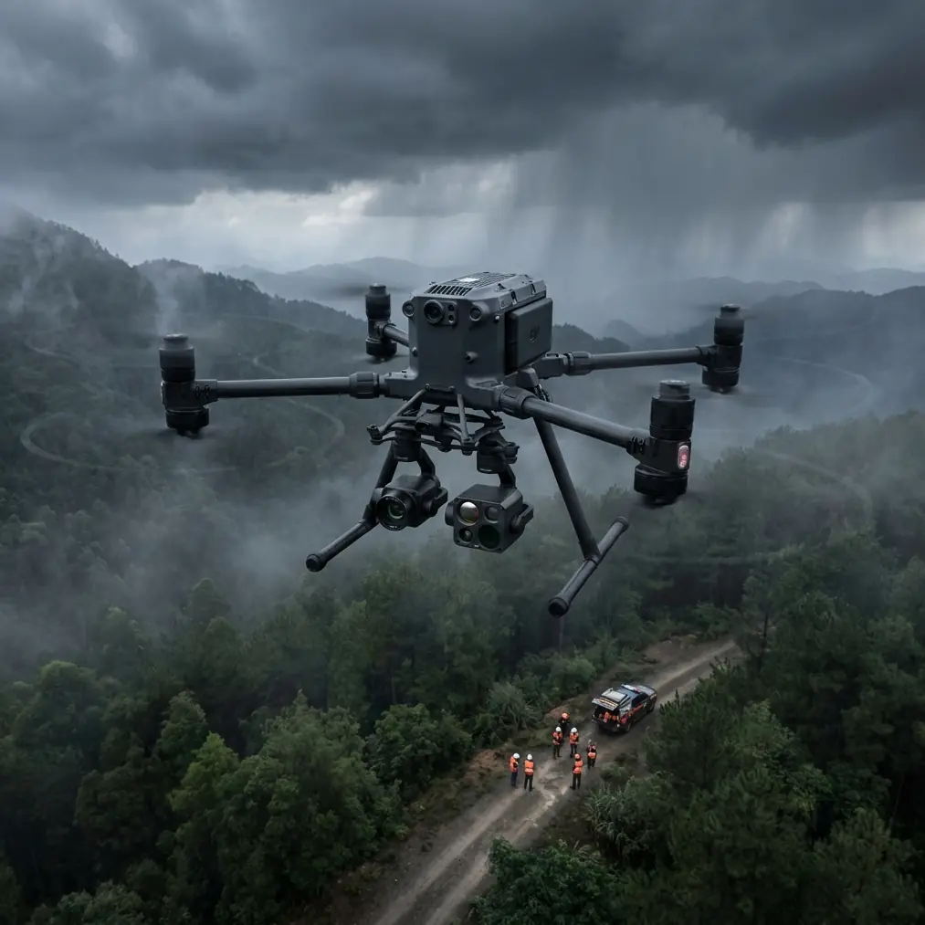
On one winter survey, we tracked a small herd moving across a broken tree line at first light. The visible camera lost contrast as shadows stretched across the snowpack, but the thermal signature remained clean enough to separate the animals from the colder background. The challenge was not just detection. It was maintaining a stable survey rhythm while the aircraft transitioned between hover checks, cross-track passes, and a changing line of sight through dense branches. In those moments, system resilience matters more than spec-sheet theater.
This guide is about how to use a Matrice 400 for wildlife surveying in extreme temperatures, with particular attention to the less glamorous engineering principles that quietly decide whether your data set is usable.
Start with the mission, not the route
Wildlife surveys usually tempt teams into overplanning the flight path and underplanning the data logic. If your objective is population counting, den-site observation, or habitat-use mapping, the aircraft setup changes.
For example:
- If you need counts at dawn or dusk, thermal signature quality may matter more than RGB detail.
- If you need habitat modeling, photogrammetry and repeatable overlap become the priority.
- If you are documenting movement corridors, transmission stability and predictable command response often outrank raw image resolution.
That sounds obvious, but it becomes critical in extreme temperatures because environmental stress narrows your margin for correction. A platform such as Matrice 400 should be configured around the most failure-sensitive part of the job.
Why reliability architecture matters in wildlife operations
The reference material behind this article comes from aircraft design practice, not consumer drone marketing, and that is exactly why it is useful.
One source highlights a core principle of fly-by-wire system design: to prevent a single-point failure, information transmission paths should not be controlled by only one control source. It also states that the transmission system should have enough capability for fault detection, isolation, and recovery from transient faults. That has direct operational significance for Matrice 400 field teams.
In wildlife surveying, especially under extreme heat or cold, transient faults are not abstract engineering jargon. They can show up as brief communication interruptions, delayed actuator response, or intermittent sensor behavior caused by temperature stress, condensation cycles, or vibration after repeated climbs and descents. A platform and workflow built around fault detection and recovery gives you a better chance of finishing a survey line without compromising safety or data continuity.
The same source also notes that critical functions in fly-by-wire systems are commonly connected through dedicated cabling between sensors, processors, and actuators, while only some non-critical functions are placed on data buses. That distinction matters because not all links inside an aircraft deserve the same level of trust. For wildlife crews, the practical lesson is straightforward: treat command-and-control, propulsion health, and navigation integrity as sacred; treat secondary display layers and convenience features as optional. When weather or temperature pushes the system, you want the aircraft’s architecture to prioritize what keeps it stable and recoverable.
This is one reason serious operators care about O3 transmission quality and encrypted links such as AES-256, but they should care in the right order. Secure, long-range transmission helps protect mission integrity and support BVLOS workflows where regulations permit, yet the deeper concern is not merely signal reach. It is whether the system can maintain dependable control pathways and degrade gracefully when the environment gets noisy.
A note on buses, bottlenecks, and field confidence
Another detail in the source material deserves more attention than it usually gets. It discusses the widely used command/response multiplex data bus standard corresponding to MIL-STD-1553B and points out a weakness: the whole bus is controlled by a centralized bus controller, creating a potential single-point failure and possible communication congestion.
Why should a Matrice 400 wildlife operator care about an avionics bus concept from crewed aircraft design?
Because the principle survives the translation from large aircraft to advanced UAV operations. Any architecture that depends too heavily on one controller or one communications bottleneck becomes more vulnerable as mission complexity rises. Add thermal imaging, live downlink review, route adjustments, terrain changes, and a moving animal target, and the operational load climbs quickly. In extreme conditions, that is when hidden fragility appears.
So when you build your survey workflow, avoid stacking too many live decisions on top of a single data path. Pre-define your trigger logic. Decide in advance when the thermal payload leads the mission and when RGB takes over for photogrammetry. Establish fallback behavior for signal degradation. If the Matrice 400 gives you strong transmission and robust system integration, use that strength to simplify the mission rather than to make it unnecessarily busy.
Extreme temperature prep: the aircraft is only half the system
A wildlife aircraft can be technically excellent and still underperform if the field process is sloppy. My checklist for extreme-temperature Matrice 400 work is built around energy continuity, sensor stability, and data repeatability.
1. Stabilize your battery strategy
Hot-swap batteries are not a convenience in this kind of work; they are a continuity tool. In cold environments, every minute spent power-cycling, waiting, or resetting increases the chance of losing the narrow detection window when wildlife is most visible thermally. In hot conditions, faster turnaround helps avoid keeping aircraft and batteries soaking in direct sun longer than necessary.
The practical advantage is simple: keep the mission cadence intact. Survey teams that preserve cadence collect cleaner comparative datasets.
2. Match sensor warm-up to the environment
Thermal payloads do not behave identically after a vehicle leaves a heated truck in subzero conditions or after it sits on a hot case lid in open summer light. Build a short calibration segment into the start of each mission. Fly a controlled line over terrain with known thermal contrast and review image consistency before committing to the full grid.
That small delay often saves an entire sortie.
3. Use GCPs when your output must stand up to scrutiny
If the mission ends in a map that will support habitat modeling, restoration planning, or environmental compliance, photogrammetry without ground discipline is weak practice. GCP placement remains one of the simplest ways to reduce avoidable uncertainty. In snow, scrubland, or low-texture terrain, it matters even more because visual tie points can become unreliable.
Matrice 400 can carry the mission well, but the accuracy claim belongs to the workflow, not just the aircraft.
Thread standards sound far removed from drones. They are not.
One of the reference documents compares BS1580 and ASME B1.1 thread standards and highlights several differences. Among them: ASME B1.1 includes additional marking requirements for special thread conditions such as longer-than-standard engagement lengths, including identifiers like “LC” and “SPL,” while BS1580 does not provide those same provisions. The source also mentions that ASME includes a 27-threads-per-inch series for thin-wall pipe in the 1/8 to 1 inch range.
At first glance, this looks unrelated to a Matrice 400 wildlife mission. It is not.
Payload security, mounting repeatability, and environmental sealing all depend on disciplined mechanical interfaces. In extreme temperatures, slight dimensional assumptions become operational problems. Different coating thicknesses, special engagement lengths, and nonstandard thread interpretations can affect how accessories seat, how vibration is transmitted, and how reliably a sensor mount remains aligned over repeated flights.
For wildlife survey teams, the operational takeaway is this: do not treat threaded adapters, antenna mounts, sensor brackets, or protective housings as interchangeable just because they seem close enough on paper. Standards divergence matters. If a component was designed around one thread convention and field-modified under another, you can introduce play, preload errors, or sealing inconsistencies. Those issues may not appear on a bench. They emerge during cold contraction, heat expansion, or repeated transport over rough access roads.
That is not theoretical. A half-degree sensor alignment drift can turn a careful thermal-to-RGB comparison into a time-consuming correction exercise.
Building a Matrice 400 wildlife survey workflow
Here is the field method I recommend when surveying animals in extreme temperatures.
Step 1: Define the detection window
Identify when the animals are most separable from the background. In cold conditions, this may be just after sunrise when body heat stands out against the landscape. In hot climates, the usable thermal window may shift earlier or later depending on ground heating.
Plan your launch so the aircraft is airborne before the window peaks.
Step 2: Divide the mission into detection and documentation passes
Do not expect one pass to do everything well.
- Detection pass: prioritize thermal signature identification, broad coverage, and stable live review.
- Documentation pass: once targets are confirmed, switch to tighter geometry for RGB confirmation or photogrammetry-grade capture.
This keeps your first sortie from becoming overloaded with conflicting objectives.
Step 3: Protect your command path
Use the best possible takeoff location for line-of-sight quality and transmission stability, even if it adds a few minutes of walking. In wooded valleys or broken terrain, a better launch point often improves the mission more than any software tweak.
If you need help designing a field-ready communications checklist for remote ecology work, you can message our UAV team directly.
Step 4: Keep the aircraft’s critical workload clean
The fly-by-wire reference makes a sharp distinction between critical pathways and non-critical functions. Apply that mentality in the field. Reduce unnecessary live overlays, avoid ad hoc payload changes between flights, and keep crew roles clear. One pilot, one payload lead, one observer. Extreme conditions punish improvisation.
Step 5: Verify overlap and control points immediately
For photogrammetry missions, do not wait until you are back at base to discover that snow glare, low vegetation contrast, or thermal shimmer compromised image matching. Review overlap health in the field. Confirm that GCPs are visible in enough frames to support later processing.
Step 6: Plan for graceful degradation
A robust operation assumes something minor will go wrong. Maybe the thermal image drifts. Maybe wind rises along a ridge. Maybe one sector of habitat becomes inaccessible due to animal movement. Build a hierarchy:
- Safe recovery
- Core count data
- Secondary habitat imagery
- Nice-to-have supplemental video
This mirrors the fault-tolerant logic discussed in the source material. Not every function deserves equal priority when conditions tighten.
What advanced actuator thinking teaches drone teams
The second reference also discusses smart servo actuators containing microprocessors that manage redundancy, fault detection, isolation, balancing, control-surface reconfiguration, and even simple backup control laws after flight-computer failure to preserve minimum flight safety.
No, a Matrice 400 wildlife operator is not redesigning servo architecture in the field. But the concept matters because it reminds us what “professional platform” should mean. It is not just lift capacity or endurance. It is the ability of the aircraft subsystems to detect faults early, isolate them, and continue operating in a controlled way long enough to protect aircraft and data.
For surveying wildlife in extreme temperatures, that translates to confidence. Confidence to run repeat transects. Confidence to maintain behaviorally appropriate stand-off distances. Confidence that if a transient system issue appears, the mission does not instantly become chaotic.
That is the kind of confidence that produces better science.
The real benchmark for Matrice 400 in conservation work
A Matrice 400 proves itself in wildlife surveys when it helps you come home with data that survives scrutiny: clear thermal detections, usable photogrammetry, repeatable geospatial control, and no drama in the aircraft log.
The engineering clues from the reference materials point in the same direction. Avoid single-point weaknesses. Prioritize critical pathways. Respect the difference between nominal compatibility and true mechanical standardization. Design the mission so fault tolerance is part of the method, not just a feature you hope the aircraft has.
That is how you make an advanced UAV earn its place in extreme-temperature ecology work.
Ready for your own Matrice 400? Contact our team for expert consultation.