How I’d Use the Matrice 400 for Wildlife Surveys in Dusty Co
How I’d Use the Matrice 400 for Wildlife Surveys in Dusty Country
META: A field-led tutorial on using Matrice 400 for wildlife surveying in dusty conditions, with practical advice on thermal workflows, transmission reliability, battery strategy, and data quality.
Dust changes everything.
It gets into connectors, coats lenses, dulls contrast, and turns simple wildlife counts into a slow exercise in compromise. I learned that the hard way on a dry-season survey where the mission looked straightforward on paper: map a broad scrub corridor, identify animals near a seasonal water source, and produce both count data and habitat context. By midday, prop wash had turned the launch zone into a cloud, visual spotters were squinting through haze, and every battery swap felt like an opportunity for contamination.
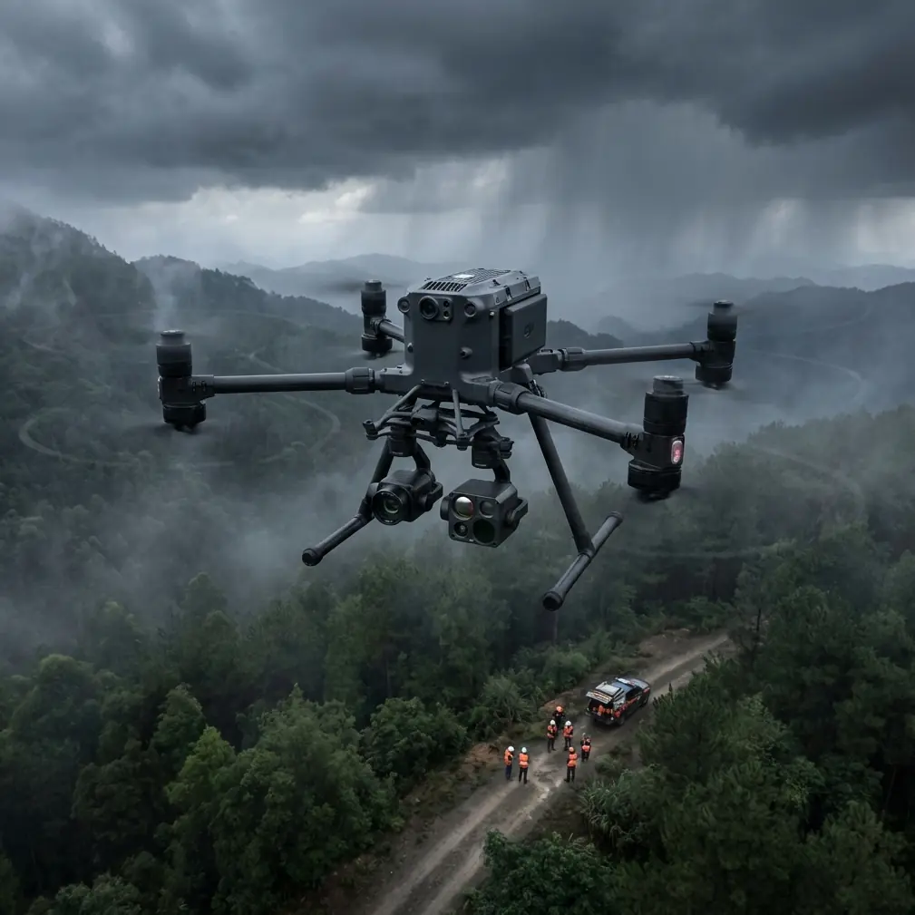
That sort of job is exactly where a platform like the Matrice 400 starts to matter—not because bigger aircraft magically solve field problems, but because the right design choices reduce the little failures that pile up over a long day. For wildlife teams working in dusty terrain, the aircraft is only one part of the answer. Payload discipline, battery handling, transmission integrity, and data capture logic matter just as much.
This is how I would approach a dusty wildlife survey with the Matrice 400, and why certain details make a real operational difference.
Start with the mission, not the airframe
Wildlife work tends to split into two simultaneous tasks.
First, you need detection: finding animals quickly and reliably against low-contrast ground. That is where thermal signature work earns its keep, especially in the early morning when animal heat stands apart from cooler terrain.
Second, you need context: where the animals were, what the vegetation looked like, how close they were to tracks, fences, water, or bare patches. That is a photogrammetry problem. It requires overlap, repeatability, and disciplined georeferencing with GCPs if the output needs to support habitat analysis or multi-date comparison.
The Matrice 400 becomes useful when it can carry that dual workflow cleanly. In practice, that means planning for one pass optimized for detection and another optimized for mapping, or building a payload configuration that lets you move between those tasks without wasting the best weather window.
In dusty environments, speed matters less than consistency. If visibility and surface disturbance are changing through the day, your system has to keep producing stable inputs even when the field conditions are degrading.
Why transmission reliability matters more than most teams admit
A lot of wildlife crews focus on optics first. Fair enough. But on remote surveys, transmission is often what protects the mission.
If you’re operating at range, especially in semi-BVLOS style workflows where the aircraft is covering broad transects over rough ground, you need confidence that your video feed and control link will stay clean enough to support decisions in real time. That is why O3-class transmission performance is not just a spec-sheet talking point. It changes how aggressively you can work a survey block before repositioning your team.
In dusty country, that matters because every unnecessary landing creates friction. More launches mean more exposure to airborne grit. More vehicle moves mean more delays. More ad hoc repositioning means more chances to lose the thermal rhythm of the site.
I’ve seen missions drift off schedule simply because the aircraft had to be babied from one short hop to the next. A stronger transmission architecture lets you keep your launch plan tighter and your track lines more deliberate. That improves coverage consistency and reduces field handling, which in dust is half the battle.
If your wildlife client also has sensitivity around location data—common with threatened species work—AES-256-level link security is not a minor detail either. It means animal location imagery, habitat data, and live video are better protected while your team is working. For conservation projects involving rare nesting areas or heavily pressured species, that protection has real value.
Dusty launches punish sloppy battery routines
Battery management is where many otherwise professional survey teams lose efficiency.
On wildlife projects, dawn and dusk are premium collection windows because thermal separation is strongest and animal activity patterns are often more useful. That leaves little tolerance for downtime. Hot-swap batteries matter here because they compress the turnaround between sorties. In the field, that means the aircraft can stay mission-ready while your crew changes packs without rebooting the whole workflow and without burning precious minutes during a temperature transition on the ground.
That sounds simple, but there’s a deeper benefit. Every extra minute an aircraft sits exposed on a dusty pad is another minute for contamination to build up. Faster swaps reduce handling time, reduce open-body exposure, and help the crew maintain momentum.
My advice is to set up battery changes like a contamination-control drill:
- one clean case for charged packs
- one separate area for used packs
- lens and payload caps ready before shutdown
- a designated crew member doing nothing except battery and connector discipline
That level of routine feels excessive until the wind picks up.
Thermal first, but don’t let thermal become your whole method
For wildlife in dusty landscapes, thermal signature work is often the fastest route to detection. Animals tucked under brush or standing off-color against dry soil may disappear in RGB but still separate cleanly in thermal, especially early in the day.
Still, thermal can tempt teams into overconfidence.
Dust in the air, warming rocks, vehicle tracks, and sun-loaded ground can all create false positives or at least ambiguous signatures later in the day. The answer is not to abandon thermal. The answer is to pair it with a verification workflow.
This is where I like the Matrice 400 conceptually for mixed-sensor fieldwork: it supports an operational style where thermal is the spotting tool and photogrammetry or high-resolution visual capture becomes the evidence layer. You detect first, then confirm, then log.
That sequence gives you stronger data products:
- thermal for locating animals
- visual imagery for species confirmation where possible
- mapped context for reporting and repeat surveys
If the job includes habitat monitoring, fly your mapping block with proper overlap and control. Use GCPs where the terrain and access allow it. Even a strong onboard positioning solution does not replace the value of ground control when the output needs to stand up across time, teams, or clients.
A useful lesson from old aviation engineering: small loads, realistic simulation
One of the more interesting engineering references behind this discussion doesn’t come from drones at all. It comes from older aircraft design literature on wheel hub stress testing.
In that reference, engineers approximated real tire contact using a rubber cord with a metal core, 10 mm in diameter, and modeled the contact angle at 180 degrees. They also separated radial and lateral loading so they could understand the relationship between the two instead of treating the entire load case as a blur. On a half-scale model, they used a radial load of 104 N and a lateral load of 50 N, and after thermal stress-freezing the model, the maximum deformation was only on the order of a few tenths of a millimeter.
Why does that matter to a Matrice 400 wildlife workflow?
Because the field lesson is the same: realistic simulation beats guesswork, and small mechanical effects accumulate. Dusty operations create off-axis handling loads, uneven landing surfaces, and frequent ground interactions. If you’ve ever wondered why some teams seem to age aircraft quickly while others get clean service life, this is part of the answer. The way forces are introduced during launch, recovery, and transport matters.
Applied to wildlife surveying, that means:
- don’t rush landings onto unstable, gritty surfaces
- avoid repeated side-loading during hand positioning or uneven pad contact
- treat dusty field handling as a structural wear issue, not only a cleanliness issue
That old wheel-hub test work focused on where stress concentrated, especially around boundary conditions and free edges. Drone operators should think similarly. Failures rarely begin in the center of the workflow. They show up at the interfaces: battery contacts, gimbal mounts, landing surfaces, payload connectors, and transport restraints.
Another engineering clue: altitude changes alter oxygen demand, and field crews feel the same pressure
A second reference from classic aircraft systems design looked at oxygen-mask flow requirements at altitude. The raw figures are for crew life-support design, not drone operations, but one detail stands out: as altitude increased, oxygen flow demand rose sharply. In the extracted table, the value near 5,639 m was 1.2174 in one listed condition, and by 8,230 m it rose to about 3.116 in another flow column.
That has nothing to do with putting oxygen systems on a Matrice 400. It does remind us that environmental stress compounds with altitude and workload. If your wildlife survey is happening on a dusty plateau, ridge system, or high inland basin, your human team will fatigue faster than the mission plan suggests. Judgment, launch discipline, spotting quality, and battery-change precision all degrade before people admit it.
Operationally, this means the Matrice 400 should be deployed with a crew rhythm that respects human performance:
- keep preflight checklists short but exact
- rotate visual observation and tablet duties
- schedule the most interpretation-heavy sorties in the cooler, earlier hours
- don’t leave species confirmation decisions to the final hour of a long dusty day
The aircraft may be capable of more, but your dataset is only as good as the team managing it.
My recommended field workflow for dusty wildlife jobs
Here is the structure I would use.
1. Dawn thermal reconnaissance
Launch at first usable light and run broad transects designed to detect animal clusters before the ground warms. Fly clean, economical lines. The goal is not cinematic footage. It is rapid thermal discrimination.
2. Immediate classification pass
Where thermal picks up targets, run a tighter pass with the appropriate visual or zoom view to confirm species or at least classify by body size and grouping behavior. Keep hover time disciplined to limit dust exposure during low-altitude work near open ground.
3. Mid-morning photogrammetry block
Once the initial wildlife activity settles, capture the habitat layer. This is where overlap, speed consistency, and GCP use matter. Build an orthomosaic that lets the client connect sightings to terrain, vegetation edges, and water access patterns.
4. Data security and chain of custody
If the site contains sensitive species, secure your files immediately and maintain clean media handling. Transmission security such as AES-256 helps in the live stage, but your real protection comes from disciplined storage and export practices after landing.
5. Controlled battery turnover
Use hot-swap capability to preserve the aircraft state and reduce idle time. Keep the aircraft off the dirt as much as possible. A compact landing surface is worth carrying into the field.
6. Evening thermal return
If the brief requires movement patterns rather than just counts, a sunset return often produces the most informative thermal footage of the day. Animals re-emerge, the background cools, and signatures sharpen again.
What made this easier compared with older workflows
The biggest improvement is not one headline feature. It is the way several practical capabilities support each other.
Reliable long-range transmission reduces needless relocations. Hot-swap batteries preserve your best survey windows. Secure links matter when wildlife location data is sensitive. A platform ready for mixed payload work lets thermal detection and photogrammetry live in the same mission architecture instead of becoming separate field days.
That combination changes the texture of the work. You spend less time recovering from friction and more time collecting interpretable data.
If you’re planning a wildlife survey in dusty conditions and need a field-sensible setup rather than a generic spec discussion, message our drone team here.
Final thought
The Matrice 400 makes the most sense when you stop thinking of it as a flying camera and start treating it as a survey system. In wildlife work, especially in dust, systems thinking wins. Launch discipline, thermal timing, mapping accuracy, secure transmission, and battery turnover all shape the quality of the final result.
That is the real difference between coming back with footage and coming back with evidence.
Ready for your own Matrice 400? Contact our team for expert consultation.